alb4859290
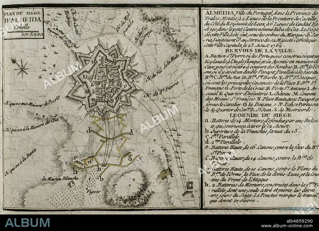
JEAN DE BEAURAIN (1696-1771). FRENCH GEOGRAPHER.. Seven Years War (1756-1763). Siege of Almeida (16 to 25 August 1762). Spanish troops led by Pedro Pablo Abarca de Bolea, Count of Aranda, besieged and took the Portuguese city during the conflict. Plan of the Siege of Almeida, 1762. Published in 1765 by the cartographer Jean de Beaurain (1696-1771) as an illustration of his Great Map of Germany, with the events that took place during the Seven Years War. Etching and engraving. French edition, 1765. Military Historical Library of Barcelona (Biblioteca Histórico Militar de Barcelona). Catalonia. Spain.
| Share |
|---|
 Pinterest Pinterest |
 Twitter Twitter |
 Facebook Facebook |
 Copy link Copy link |
 Email Email |
|
Add to another lightbox |
|
Add to another lightbox |


Buy this image.
Select the use:

Caption:
Seven Years War (1756-1763). Siege of Almeida (16 to 25 August 1762). Spanish troops led by Pedro Pablo Abarca de Bolea, Count of Aranda, besieged and took the Portuguese city during the conflict. Plan of the Siege of Almeida, 1762. Published in 1765 by the cartographer Jean de Beaurain (1696-1771) as an illustration of his Great Map of Germany, with the events that took place during the Seven Years War. Etching and engraving. French edition, 1765. Military Historical Library of Barcelona (Biblioteca Histórico Militar de Barcelona). Catalonia. Spain.
Location:
Historical Military Library of Barcelona. Catalonia. Spain.
Credit:
Album / Prisma
Releases:
Model: No - Property: No
Rights questions?
Rights questions?
Image size:
4961 x 3334 px | 47.3 MB
Print size:
42.0 x 28.2 cm | 16.5 x 11.1 in (300 dpi)
Keywords:
1762 • 1765 • 18 CENTURY • 18TH CENTURY • 18TH CENTURY, THE • 18TH • ALMEIDA • ANCIENT MAP • ANCIENT PLAN • ANCIENT • ANTIQUE • ARMY, SPANISH • AUGUST 1762 • BASTION • BEAURAIN • BESIEGE • BESIEGED • BULWARK • CAMP • CARTOGRAPHY • CASTILLO • CASTLE • CHATEAU • CITADEL • CITY WALLS • CITY • COLONIAL WARS • COLONIALISM • CONFLICT • CONFLICTS • COUNT OF ARANDA • DEFENSIVE ARCHITECTURE • DEFENSIVE • ENGRAVED • ENGRAVING (ARTWORK) • ENGRAVING • ENGRAVING. • ENGRAVINGS • ETCHING • EUROPA • EUROPE • EUROPEA • EUROPEAN • EUROPEANS • FANTASTIC WAR • FORT • FORTIFICACION • FORTIFICATION • FORTITUDE • FORTRESS • FRANCE • FRANÇAIS • FRENCH EDITION • FRENCH • GREAT MAP OF GERMANY • HISTORIA DE ESPANA • HISTORIA UNIVERSAL • HISTORIA • HISTORICAL MILITARY LIBRARY OF BARCELONA. CATALONIA. SPAIN. • HISTORY OF SPAIN • HISTORY SPAIN • HISTORY • HISTORY, SPAIN • HUNDRED YEARS WAR • IBERIAN PENINSULA • INVASION • JEAN DE BEAURAIN (1696-1771). FRENCH GEOGRAPHER. • JEAN DE BEAURAIN • MAP MAKING • MAP • MAPS • MILITAR • MILITARS • MILITARY • MODERN AGE • MODERN ERA • MODERN PERIOD • OLD MAP • OLD • PALACE • PEDRO PABLO ABARCA DE BOLEA • PLAN (CARTOGRAPHY) • PLAN • PLANE • PORTUGAL • PORTUGUESE CITY • PORTUGUESE • PRINT • RAMPART • SEVEN YEARS WAR • SEVEN YEARS' WAR • SIEGE OF ALMEIDA • SIEGE • SILESIAN WAR • SITE • SPAIN • SPAIN, HISTORY • SPANISH ARMY • SPANISH EMPIRE • SPANISH TROOPS • SPANISH • SPANISHPORTUGUESE WAR • STRATEGY • STRENGTH • STRONGHOLD • URBE • VILLAGE • WALL • WAR IN THE COLONIES • WAR • WAR, SEVEN YEARS • WAR, SILESIAN • WARFARE • WARS • XVIII CENTURY
