alb9395601
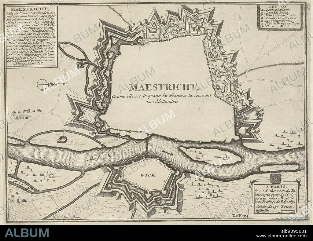
Map of the fortifications around Maastricht, besieged and captured by the French army, June 27-30, 1673. Top left a cartouche outlining the history of the city from 1633 to 1678. Top right the legend A-E and 1-2 in French, Map of Maastricht, 1673 Maestricht. Comme elle estoit quand les Francois la remirent aux Hollandois , print maker: Harmanus van Loon, (mentioned on object), publisher: unknown, Lodewijk XIV (koning van Frankrijk), (mentioned on object), Paris, 1693, paper, etching, h 200 mm × w 275 mm.
| Share |
|---|
 Pinterest Pinterest |
 Twitter Twitter |
 Facebook Facebook |
 Copy link Copy link |
 Email Email |
|
Add to another lightbox |
|
Add to another lightbox |


Buy this image.
Select the use:

Caption: Map of the fortifications around Maastricht, besieged and captured by the French army, June 27-30, 1673. Top left a cartouche outlining the history of the city from 1633 to 1678. Top right the legend A-E and 1-2 in French, Map of Maastricht, 1673 Maestricht. Comme elle estoit quand les Francois la remirent aux Hollandois , print maker: Harmanus van Loon, (mentioned on object), publisher: unknown, Lodewijk XIV (koning van Frankrijk), (mentioned on object), Paris, 1693, paper, etching, h 200 mm × w 275 mm
Credit: Album / quintlox
Releases: ? Model Release: No - ? Property Release: No
Rights questions?
Rights questions?
Image size: 4221 × 3034 px | 36.6 MB
Print size: 35.7 × 25.7 cm | 1661.8 × 1194.5 in (300 dpi)
Keywords: 1-2 • 1633 • 1673 MAESTRICHT • 1673 • 1678 • 1693 • BESIEGED • CAPTURED • CARTOUCHE OUTLINING • CITIES • CITY • CIUDAD • COMME ELLE ESTOIT QUAND LES FRANCOIS LA REMIRENT AUX HOLLANDOIS • ETCHING • FORTIFICATIONS • FRENCH ARMY • FRENCH • H 200 MM × W 275 MM • HARMANUS VAN LOON • HISTORIA UNIVERSAL • HISTORIA • HISTORY • HISTORY. • JUNE 27-30 • KONING VAN FRANKRIJK • LEGEND A-E • LODEWIJK XIV • MAASTRICHT • MAP • MAPS • MENTIONED • OBJECT • OBJECTS • PAPER AND PACKAGE PRODUCTS • PAPER • PARIS • PLAN (CARTOGRAPHY) • PRINT MAKER • PUBLISHER • TOP LEFT • TOP RIGHT • TOWN • TOWNS • UMBRELLA • UNKNOWN
