alb1963704
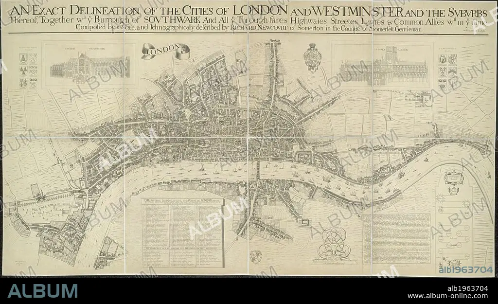
RICHARD NEWCOURT. A map of the Cities of London and Westminster. It depicts London as it stood during the last two years of the Commonwealth, before the Great Fire. Dense clusters of houses appear very close together, separated only by narrow streets - an indication of the city's vulnerability to fire. An exact delineation of the Cities of London and Westminster and the suburbs thereof, together wth. ye Burrough of Southwark. 1857. This is a copy of the 1658 Faithorne map made in 1857. . Source: Maps.Crace.I.35.
| Share |
|---|
 Pinterest Pinterest |
 Twitter Twitter |
 Facebook Facebook |
 Copy link Copy link |
 Email Email |
|
Add to another lightbox |
|
Add to another lightbox |


Buy this image.
Select the use:

Author:
Caption:
A map of the Cities of London and Westminster. It depicts London as it stood during the last two years of the Commonwealth, before the Great Fire. Dense clusters of houses appear very close together, separated only by narrow streets - an indication of the city's vulnerability to fire. An exact delineation of the Cities of London and Westminster and the suburbs thereof, together wth. ye Burrough of Southwark. 1857. This is a copy of the 1658 Faithorne map made in 1857. . Source: Maps.Crace.I.35.
Credit:
Album / British Library
Releases:
Model: No - Property: No
Rights questions?
Rights questions?
Image size:
10000 x 5589 px | 159.9 MB
Print size:
84.7 x 47.3 cm | 33.3 x 18.6 in (300 dpi)
Keywords:
17TH CENTURY • 17TH • 19 CENTURY • 19TH CENTURY • 19TH CENTURY. • 19TH • 19TH-CENTURY • ACCIDENT • ALBION • ANNIVERSARIES 2016 • ANNIVERSARIES • ANNIVERSARY 2016 • ANNIVERSARY • BIRTHDAY • BRITAIN • BRITISH ISLES • CALAMITY • CARTE • CARTOGRAPHIC • CARTOGRAPHY • CATASTROPHE • CITY OF LONDON • DATE BY CENTURY OF WORK OR SCENE • DISASTER • DISASTERS • ENGLAND'S • ENGLAND • EUROPA • EUROPE • EVENT • EVENTS • FIRE OF LONDON • GREAT BRITAIN • GREAT FIRE OF LONDON • LONDON • LONDON. • MAN-MADE DISASTER BY NAME • MAN-MADE DISASTER • MAN-MADE DISASTERS • MAP MAKING • MAP • MAPS • MISFORTUNE • NEWCOURT, RICHARD • NINETEENTH CENTURY • PLAN (CARTOGRAPHY) • RIO • RIVER THAMES • RIVER • RIVERS • SOUTHWARK • STYLE AND PERIOD • THAMES RIVER • THAMES • U. K. • UNITED KINGDOM • WESTERN EUROPE • WESTMINSTER • XIX CENTURY • XVII CENTURY
