alb9451430
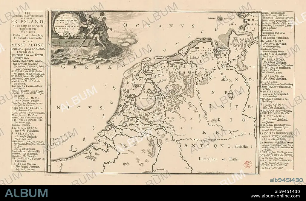
Historical map of the Netherlands with the territories of the Batavians and Frisians, Summaria descriptio Fresiae universae (...) / Algemeene afteekeninge van geheel Friesland (...) (title on object), Map of the Batavian and Frisian territories in the Netherlands and Germany in Roman times. Top left cartouche with title. Next to the title is a male figure wearing a crown with two horns, in one hand he carries a captain's staff, in his other hand a lance on which hangs the liberty hat. In the background is a woman holding a sheaf of corn (possibly Ceres). Scale stick below cartouche: As gradus. On the left and right edges a degree division. To the left and right of the print strips of letterpress text with Dutch translation of the title (upper left) and terms used on the map., print maker: Gerrit de Broen (I), (mentioned on object), Menso Alting, (mentioned on object), Amsterdam, 1697 - 1700 and/or 1718 and/or 1725, paper, engraving, etching, letterpress printing, height 326 mm × width 421 mm, height 326 mm × width 549 mm.
| Share |
|---|
 Pinterest Pinterest |
 Twitter Twitter |
 Facebook Facebook |
 Copy link Copy link |
 Email Email |
|
Add to another lightbox |
|
Add to another lightbox |


Caption:
Historical map of the Netherlands with the territories of the Batavians and Frisians, Summaria descriptio Fresiae universae (...) / Algemeene afteekeninge van geheel Friesland (...) (title on object), Map of the Batavian and Frisian territories in the Netherlands and Germany in Roman times. Top left cartouche with title. Next to the title is a male figure wearing a crown with two horns, in one hand he carries a captain's staff, in his other hand a lance on which hangs the liberty hat. In the background is a woman holding a sheaf of corn (possibly Ceres). Scale stick below cartouche: As gradus. On the left and right edges a degree division. To the left and right of the print strips of letterpress text with Dutch translation of the title (upper left) and terms used on the map., print maker: Gerrit de Broen (I), (mentioned on object), Menso Alting, (mentioned on object), Amsterdam, 1697 - 1700 and/or 1718 and/or 1725, paper, engraving, etching, letterpress printing, height 326 mm × width 421 mm, height 326 mm × width 549 mm
Credit:
Album / quintlox
Releases:
Model: No - Property: No
Rights questions?
Rights questions?
Image size:
5048 x 3064 px | 44.3 MB
Print size:
42.7 x 25.9 cm | 16.8 x 10.2 in (300 dpi)
Keywords:
1697 • 1700 • 1718 • 1725 • ALGEMEENE AFTEEKENINGE VAN GEHEEL FRIESLAND • AMSTERDAM • BACKGROUND • BATAVIAN • BATAVIANS • CAPTAIN'S STAFF • CARRIES • CARTOUCHE • CERES • CORN (VEGETABLE) • CORN • CROWN • DEGREE DIVISION • DUTCH TRANSLATION • ENGRAVED • ENGRAVING (ARTWORK) • ENGRAVING • ENGRAVING. • ENGRAVINGS • ETCHING • FRISIAN TERRITORIES • FRISIANS • GERMANY • GERRIT DE BROEN • GRADUS • HAND • HANGS • HEIGHT 326 MM × WIDTH 421 MM • HEIGHT 326 MM × WIDTH 549 MM • HISTORICAL MAP • I • LANCE • LEFT • LETTERPRESS PRINTING • LETTERPRESS TEXT • LIBERTY HAT • MAIZ • MAIZE = CORN (VEGETABLE) • MAIZE • MALE FIGURE WEARING • MAP • MAPS • MENSO ALTING • MENTIONED • NETHERLANDS • NEXT • OBJECT • OBJECTS • PAPER AND PACKAGE PRODUCTS • PAPER • PLAN (CARTOGRAPHY) • PRINT MAKER • PRINT STRIPS • PRINT • PUNT • RIGHT EDGES • RIGHT • ROMAN TIMES • SCALE STICK • SHEAF • SUMMARIA DESCRIPTIO FRESIAE UNIVERSAE • TERMS • TERRITORIES • TITLE • TOP LEFT CARTOUCHE • TWO HORNS • UMBRELLA • UPPER LEFT • WOMAN HOLDING • ZEA MAYS
