alb1960865
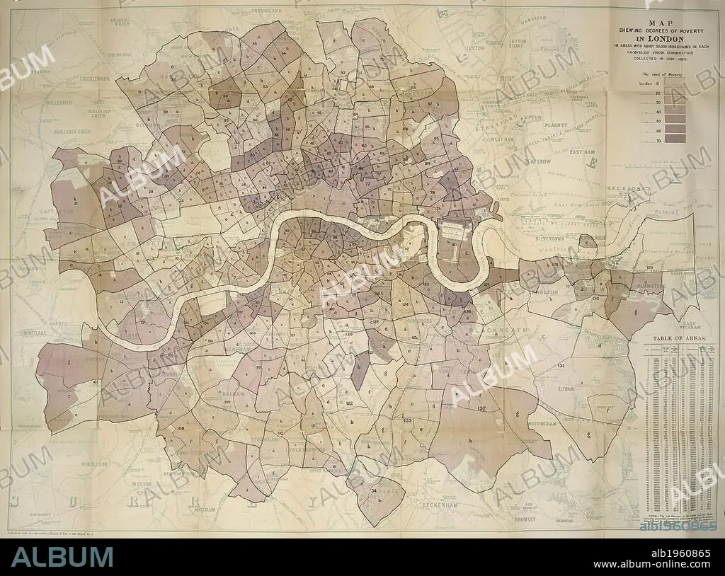
Booth's map of poverty levels in London, 1891. Descriptive map of London poverty 1889. London, England. Charles Booth, a shipowner, sought to refute socialist allegations that a quarter of London’s population lived in poverty. He thought this exaggerated, but his researches, published in 17 volumes, revealed that the true figure was even higher at one third. Here his extensive survey is presented in cartographical form with the levels of poverty colour coded. This sometimes conceals as much as it reveals. The purple of the mixed areas obscured much poverty while domestic servants in the yellow areas would hardly have been wealthy. Although he has no qualms about labelling the very poorest areas ’vicious semi-criminal’ no comments are made about the ethics of the rich." Scale 1:10 560. 1 map on 4 sheets ; sheets 46 x 59cm. Source: Maps.C.21.a.18 map1. Language: English.
| Share |
|---|
 Pinterest Pinterest |
 Twitter Twitter |
 Facebook Facebook |
 Copy link Copy link |
 Email Email |
|
Add to another lightbox |
|
Add to another lightbox |


Author:
Caption:
Booth's map of poverty levels in London, 1891. Descriptive map of London poverty 1889. London, England. Charles Booth, a shipowner, sought to refute socialist allegations that a quarter of London’s population lived in poverty. He thought this exaggerated, but his researches, published in 17 volumes, revealed that the true figure was even higher at one third. Here his extensive survey is presented in cartographical form with the levels of poverty colour coded. This sometimes conceals as much as it reveals. The purple of the mixed areas obscured much poverty while domestic servants in the yellow areas would hardly have been wealthy. Although he has no qualms about labelling the very poorest areas ’vicious semi-criminal’ no comments are made about the ethics of the rich." Scale 1:10 560. 1 map on 4 sheets ; sheets 46 x 59cm. Source: Maps.C.21.a.18 map1. Language: English.
Credit:
Album / British Library
Releases:
Model: No - Property: No
Rights questions?
Rights questions?
Image size:
4530 x 3368 px | 43.7 MB
Print size:
38.4 x 28.5 cm | 15.1 x 11.2 in (300 dpi)
Keywords:
19TH CENTURY • 19TH • BRITISH ISLES • BRITISH LIBRARY EXHIBITION • BRITISH LIBRARY EXHIBITIONS • CHARLES BOOTH • CITY OF LONDON • COLOR • COLORS • COLOUR • COLOURS • DATE BY CENTURY OF WORK OR SCENE • ENGLAND • EUROPA • EUROPE • EVENT • EVENTS • GOTHIC EXHIBITION • GREAT BRITAIN • LONDON • LONDON. • MAP • MAPS • PLAN (CARTOGRAPHY) • POVERTY • RIVER THAMES • SOCIAL SCIENCES • SOCIETY CONCEPT • STYLE AND PERIOD • TERROR AND WONDER GOTHIC IMAGINATION • TERROR AND WONDER THE GOTHIC IMAGINATION • TERROR AND WONDER • TERROR AND WONDER: THE GOTHIC IMAGINATION • THAMES • WESTERN EUROPE • XIX CENTURY
