alb9354753
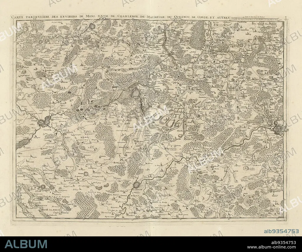
Map of Hainaut and Northern France, 1706, Carte particuliere des environs de Mons, d'Ath, de Charleroy, de Maubeuge, du Quesnoy, de Condé, et autres (title on object), Map of Hainaut and Northern France with the towns of Mons, Ath, Charleroi, Maubeuge, le Quesnoy and Condé, 1706. Part of a bundled collection of plans of battles and cities renowned in the War of the Spanish Succession. This plate is among the first 24 plates that make up a very large map of the Southern Netherlands., print maker: Jacobus Harrewijn (mentioned on object), publisher: Eugene Henry Fricx (mentioned on object), Brussels, 1706, paper, etching, engraving, height 428 mm × width 565 mm.
| Share |
|---|
 Pinterest Pinterest |
 Twitter Twitter |
 Facebook Facebook |
 Copy link Copy link |
 Email Email |
|
Add to another lightbox |
|
Add to another lightbox |


Buy this image.
Select the use:

Caption: Map of Hainaut and Northern France, 1706, Carte particuliere des environs de Mons, d'Ath, de Charleroy, de Maubeuge, du Quesnoy, de Condé, et autres (title on object), Map of Hainaut and Northern France with the towns of Mons, Ath, Charleroi, Maubeuge, le Quesnoy and Condé, 1706. Part of a bundled collection of plans of battles and cities renowned in the War of the Spanish Succession. This plate is among the first 24 plates that make up a very large map of the Southern Netherlands., print maker: Jacobus Harrewijn (mentioned on object), publisher: Eugene Henry Fricx (mentioned on object), Brussels, 1706, paper, etching, engraving, height 428 mm × width 565 mm
Personalities: JACOBUS HARREWIJN
Credit: Album / quintlox
Releases: ? Model Release: No - ? Property Release: No
Rights questions?
Rights questions?
Image size: 4896 × 3834 px | 53.7 MB
Print size: 41.5 × 32.5 cm | 1927.6 × 1509.4 in (300 dpi)
Keywords: 1706 • ATH • BATTLES • BRUSSELS • BUNDLED COLLECTION • CARTE PARTICULIERE DES ENVIRONS DE MONS • CHARLEROI • CITIES RENOWNED • CITIES • CITY OF BRUSSELS • CITY • CIUDAD • CONDE • D'ATH • DE CHARLEROY • DE CONDÉ • DE MAUBEUGE • DISH • DU QUESNOY • ENGRAVED • ENGRAVING (ARTWORK) • ENGRAVING • ENGRAVING. • ENGRAVINGS • ET AUTRES • ETCHING • EUGENE HENRY FRICX • FIRST 24 PLATES • GUERRA • HAINAUT • HEIGHT 428 MM • HUNDRED YEARS WAR • JACOBUS HARREWIJN • LARGE MAP • LE QUESNOY • MAP • MAPS • MAUBEUGE • MENTIONED • MONS VENERIS • MONS • NORTHERN FRANCE • PAPER AND PACKAGE PRODUCTS • PAPER • PART • PLAN (CARTOGRAPHY) • PLANS • PLATE • PRINT MAKER • PRINT • PUBLISHER • SOUTHERN NETHERLANDS • SPANISH SUCCESSION • TOWN • TOWNS • UP A • WAR • WARFARE • WARS • WIDTH 565 MM
