alb1651927
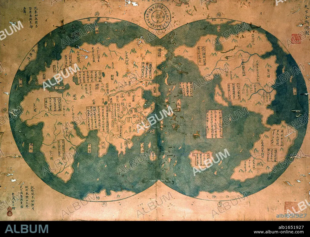
Chinese map of the world dated 1763, claiming to be a reproduction of a 1418 map of Zheng He's (1371-1433) voyages and to prove that Zheng He sailed both to Australia and the Americas. Many think the map is more likely to be based on 18th century European maps. Discovered by Lui Gang in 2005.
| Share |
|---|
 Pinterest Pinterest |
 Twitter Twitter |
 Facebook Facebook |
 Copy link Copy link |
 Email Email |
|
Add to another lightbox |
|
Add to another lightbox |


Buy this image.
Select the use:

Caption: Chinese map of the world dated 1763, claiming to be a reproduction of a 1418 map of Zheng He's (1371-1433) voyages and to prove that Zheng He sailed both to Australia and the Americas. Many think the map is more likely to be based on 18th century European maps. Discovered by Lui Gang in 2005.
Category: UIG HISTORY
Credit: Album / Universal Images Group / Universal History Archive
Releases: ? Model Release: No - ? Property Release: No
Rights questions?
Rights questions?
Image size: 3533 × 2523 px | 25.5 MB
Print size: 29.9 × 21.4 cm | 1390.9 × 993.3 in (300 dpi)
Keywords: 1371-1433 • 1418 • 15 15TH XV XVTH FIFTEENTH CENTURY • 15TH CENTURY • 15TH CENTURY; • 15TH • 1763 • 18TH CENTURY • 18TH CENTURY, THE • 18TH CENTURY. • 18TH • 2005 • AMERICA • AMERICA. • AMERICAS • AMERICAS, THE • AUSTRALIA • BASED • BOTH • BREEDING • CARTOGRAPHY • CENTURY • CHINESE • CLAIMING • DATED • DISCOVERED • DISCOVERY • EIGHTEENTH CENTURY • EUROPEA • EUROPEAN • EUROPEANS • EXPLORATION • FIFTEENTH CENTURY • FIFTEENTH • GANG • GEOGRAFIA • GEOGRAPHY • LIKELY • LUI • MANY • MAP MAKING • MAP • MAPS • MORÉ • PLAN (CARTOGRAPHY) • PROVE • REPRODUCTION • SAILED • SIGLO XV • THINK • UIG HISTORY • VOYAGES • WORLD • XV CENTURY • XVIII CENTURY • ZHENG
