alb3802820
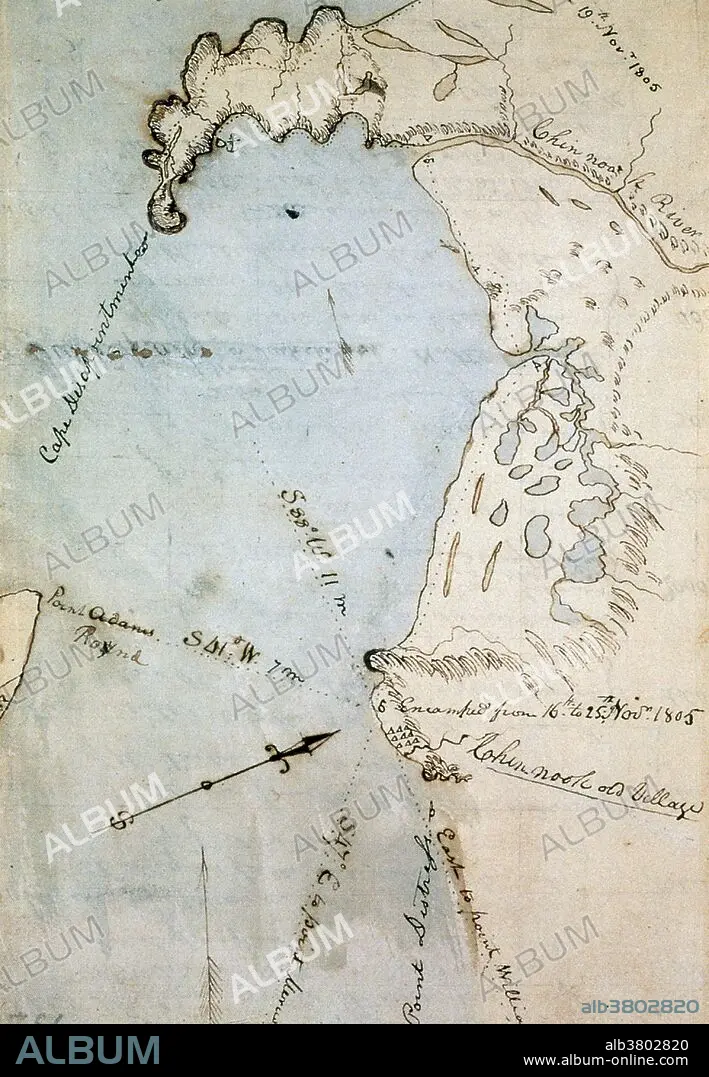
William Clark's Map of Gray's Bay, 1805
| Share |
|---|
 Pinterest Pinterest |
 Twitter Twitter |
 Facebook Facebook |
 Copy link Copy link |
 Email Email |
|
Add to another lightbox |
|
Add to another lightbox |


Buy this image.
Select the use:

Title:
William Clark's Map of Gray's Bay, 1805
Caption:
Map of Gray's Bay, in Pacific and Wahkiakum counties, Washington state, made by William Clark (of Lewis & Clark) in November 1805. The bay was originally mistaken for the Pacific ocean, leading to the moniker of "Cape Disappointment" visible on the upper left. Commissioned by President Thomas Jefferson and led by Meriwether Lewis and William Clark, the expedition had several goals; to study the area's plants, animal life, and geography, to discover how the region could be exploited economically and to find a direct and practicable water route for commerce with Asia (the Northwest Passage).They were accompanied by a fifteen-year-old Shoshone Indian woman, Sacagawea, the wife of a French-Canadian fur trader. After crossing the Rocky Mountains, the expedition reached the Pacific Ocean in present-day Oregon in November 1805. They returned in 1806, bringing with them an immense amount of information about the region as well as numerous plant and animal specimens.
Category:
ILLUSTRATION • History: United States
Credit:
Album / Science Source / New York Public Library
Releases:
Image size:
3057 x 4418 px | 38.6 MB
Print size:
25.9 x 37.4 cm | 10.2 x 14.7 in (300 dpi)
Keywords:
1804-1806 • 1805 • 19TH CENTURY • AMERICA • AMERICAN WEST • AMERICAN • ANIMAL SPECIMENS • ARMIES ARMY • ARMIES • ARMY • CAPTAIN • CARTOGRAPHY • CORPS OF DISCOVERY EXPEDITION • DIAGRAM • DIRECT WATER ROUTE • DISCOVERER • DRAWING • EXPEDITION • EXPLORATION • EXPLORER • FIRST TRANSCONTINENTAL EXPEDITION • GEOGRAFIA • GEOGRAPHY • GRAY'S BAY • GRAYS BAY • HISTORIC • HISTORICAL • HISTORY • HISTORY: UNITED STATES • ILLUSTRATION • ILLUSTRATIONS • INDIAN AGENT • LEWIS & CLARK • LEWIS AND CLARK EXPEDITION • LEWIS AND CLARK • MAP MAKING • MAP • MAPMAKING • MAPPING • MILITARY • MILITIA • NORTHWEST PASSAGE • PACIFIC COAST • PACIFIC NORTHWEST • PACIFIC • PASSAGE • PLANT SPECIMENS • RESEARCHER (MALE) • RESEARCHER • SACAGAWEA • SKETCH • SKIPPER • SOLDIER • TRANSCONTINENTAL EXPEDITION • UNITED STATES • US • USA • WASHINGTON STATE • WATER PASSAGE • WATER ROUTE • WEST • WILLIAM CLARK
