alb3897622
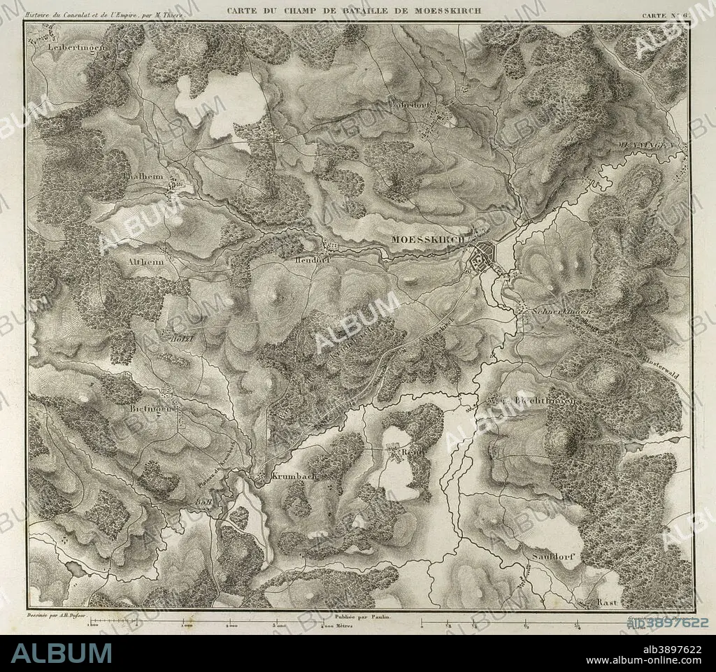
Map of the Battle of Moesskirch, 4th-5th May 1800, between the armies of France and the Holy German Roman Empire. War of the Second Coalition (context of the French Revolutionary Wars, with French victory). Atlas de l'Histoire du Consulat et de l'Empire. History of the Consulate and the Empire of France under Napoleon by Marie Joseph Louis Adolphe Thiers (1797-1877). Drawings by Dufour, engravings by Dyonnet. Edited in Paris, 1864.
| Share |
|---|
 Pinterest Pinterest |
 Twitter Twitter |
 Facebook Facebook |
 Copy link Copy link |
 Email Email |
|
Add to another lightbox |
|
Add to another lightbox |


Buy this image.
Select the use:

Caption:
Map of the Battle of Moesskirch, 4th-5th May 1800, between the armies of France and the Holy German Roman Empire. War of the Second Coalition (context of the French Revolutionary Wars, with French victory). Atlas de l'Histoire du Consulat et de l'Empire. History of the Consulate and the Empire of France under Napoleon by Marie Joseph Louis Adolphe Thiers (1797-1877). Drawings by Dufour, engravings by Dyonnet. Edited in Paris, 1864.
Personalities:
Credit:
Album / Prisma
Releases:
Image size:
4134 x 3667 px | 43.4 MB
Print size:
35.0 x 31.0 cm | 13.8 x 12.2 in (300 dpi)
Keywords:
1789 • 1800'S • 1800 • 1864 • 19 CENTURY • 19TH CENTURY • 19TH CENTURY. • 19TH • 19TH-CENTURY • 2ND COALITION • 4 • 5 • ADOLPHE THIERS • ANCIENT CARTOGRAPHY • ANCIENT • ANTIQUE • ARMIES ARMY • ARMIES • ARMY'S • ARMY • ATLANTE • ATLANTEAN • ATLAS DE L'HISTOIRE DU CONSULAT ET DE L'EMPIRE • ATLAS • AUSTRIANS • BATTLE OF MESSKIRCH • BATTLE • BATTLEFIELD • CAMPAIGNS • CARTOGRAPHY • CARTOONIST • COMBAT • CONSULATE • DESIGNING • DISPUTE • DRAWING • DRAWN • DUFOUR • DYONNET • EDITION • EMPIRE • ENGRAVED • ENGRAVER • ENGRAVING (ARTWORK) • ENGRAVING • ENGRAVING. • ENGRAVINGS • ETCHING • EUROPA • EUROPE • EUROPEA • EUROPEAN • EUROPEANS • FIGHT • FIGHTING • FIRST FRENCH EMPIRE • FRANCE • FRANCE. • FRANÇAIS • FRENCH EMPIRE • FRENCH REVOLUTION (1789-99) • FRENCH REVOLUTION • FRENCH REVOLUTION,1789 • FRENCH REVOLUTIONARY WARS • FRENCH VICTORY • FRENCH • FRENCHS • GEOGRAFIA • GEOGRAPHICAL • GEOGRAPHY • GERRMANY • GUERRA • HABSBURG AUSTRIA • HISTORIA UNIVERSAL • HISTORIA • HISTORIC • HISTORICAL • HISTORY OF THE CONSULATE AND THE EMPIRE OF FRANCE UNDER NAPOLEON • HISTORY OF THE CONSULATE AND THE NAPOLEON EMPIRE • HISTORY • HISTORY. • HUNDRED YEARS WAR • KRUMBACH • LA FRANCE • MAP MAKING • MAP • MAP-MAKING • MAPS • MARIE JOSEPH LOUIS ADOLPHE THIERS • MAY • MAYPOLE • MESSKIRCH • NAPOLEON I BONAPARTE • NAPOLEON I • NAPOLEON'S FRENCH EMPIRE • NAPOLEON • NAPOLEONIC EMPIRE • NAPOLEONIC MAP • NINETEENTH CENTURY • NO 4 • NO.4 • OLD • PLAN (CARTOGRAPHY) • PRESENT-DAY GERMANY • PRINT • PUBLICATION • REVOLUTION 1789, FRENCH • SCUFFLE • SECOND COALITION • STRUGGLE • TERRITORY • THIERS • WAR OF THE SECOND COALITION • WAR • WARFARE • WARS • WORK • WORKING • XIX CENTURY
