alb5406382
Joan Blaeu, The Caribbean Map, 17th Century
| Share |
|---|
 Pinterest Pinterest |
 Twitter Twitter |
 Facebook Facebook |
 Copy link Copy link |
 Email Email |
|
Add to another lightbox |
|
Add to another lightbox |


Buy this image.
Select the use:

Title: Joan Blaeu, The Caribbean Map, 17th Century
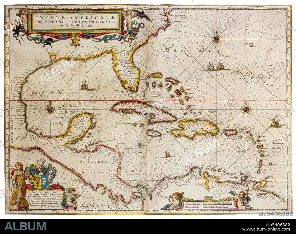
Caption: The Caribbean is a region that consists of the Caribbean Sea, its islands and the surrounding coasts. The region is southeast of the Gulf of Mexico and the North American mainland, east of Central America, and north of South America. Joan Blaeu (September 23, 1596, December 21, 1673) was a Dutch cartographer born in Alkmaar, the son of cartographer Willem Blaeu. In 1620 he became a doctor of law but he joined the work of his father. In 1635 they published the Atlas Novus (full title: Theatrum orbis terrarum, sive, Atlas novus) in two volumes. The Atlas Maior is the final version of Joan Blaeu's atlas, published in Amsterdam between 1662 and 1672, in Latin, French, Dutch, German and Spanish, containing 594 maps and around 3,000 pages of text. The Blaeu maps emphasized fine art and colours, being the most expensive of the time. The Atlas Maior is widely considered a masterpiece of the Golden Age of Dutch/Netherlandish cartography.
Credit: Album / Science Source
Releases: ? Model Release: No - ? Property Release: No
Rights questions?
Rights questions?
Image size: 4350 × 3221 px | 40.1 MB
Print size: 36.8 × 27.3 cm | 1712.6 × 1268.1 in (300 dpi)
Keywords: 1600S • 17TH CENTURY • 17TH CENTURY. • 17TH • 17TH-CENTURY • AGE • ÂGÉS • ATLAS • BLAEU • CARIBBEAN • CARTOGRAPHIC • CARTOGRAPHICAL • CARTOGRAPHY • CATALAN • CELEBRITIES • CELEBRITY • CENTURY • CHART • CUBA • DUTCH / NETHERLANDISH • DUTCH • FAMOUS PEOPLE • FAMOUS • GEOGRAFIA • GEOGRAPHIC • GEOGRAPHICAL • GEOGRAPHY • GOLDEN • GULF • HISPANIOLA • HISTORIC • HISTORICAL • HISTORY • HONDURAS • IMPORTANT • INFLUENTIAL • ISLA • ISLAND • ISLANDS • JOAN • MAKING • MAP MAKING • MAP • MAP-MAKING • MAPMAKING • MEXICO • NAVIGATION • NAVIGATIONAL • NOTABLE • NOVUS • OF • OLD • PORTOLAN • PORTOLANO • PORTULAN • SEA • SEVENTEETH • WELL-KNOWN • XVII CENTURY
