alb2158709
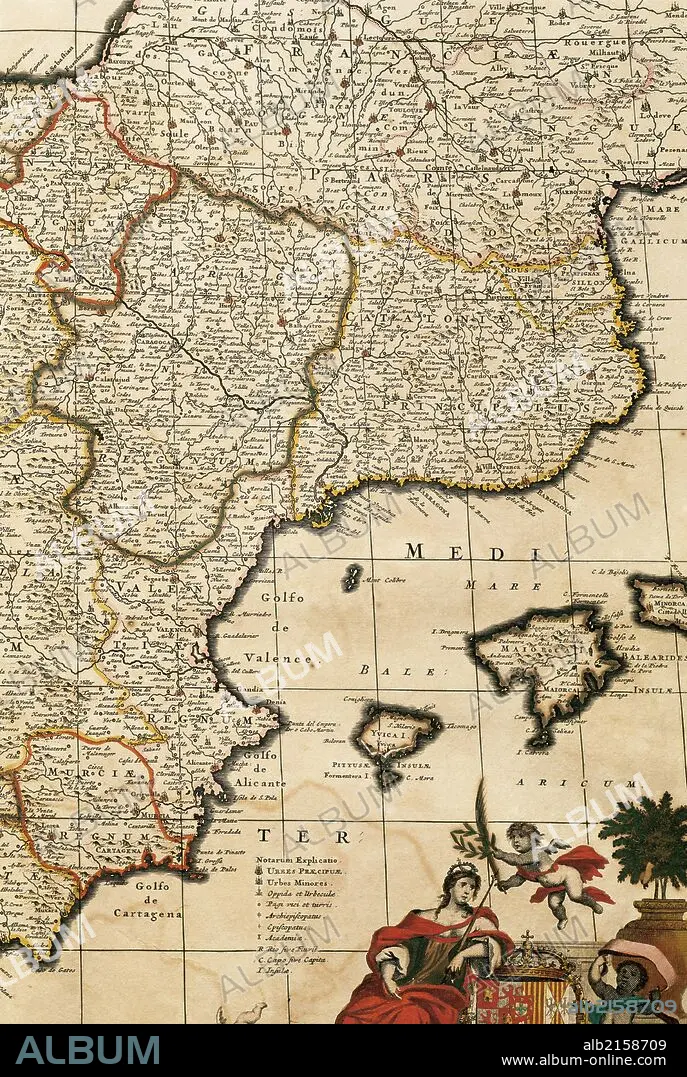
Map of the Principality of Catalonia, Kingdoms of Navarre, Aragon, Valencia, Murcia and the Balearic Islands. Atlas by Frederik de Wit (1630-1706). Amsterdam, 17th century.
| Share |
|---|
 Pinterest Pinterest |
 Twitter Twitter |
 Facebook Facebook |
 Copy link Copy link |
 Email Email |
|
Add to another lightbox |
|
Add to another lightbox |


Buy this image.
Select the use:

Caption:
Map of the Principality of Catalonia, Kingdoms of Navarre, Aragon, Valencia, Murcia and the Balearic Islands. Atlas by Frederik de Wit (1630-1706). Amsterdam, 17th century.
Credit:
Album / Prisma
Releases:
Image size:
3625 x 5400 px | 56.0 MB
Print size:
30.7 x 45.7 cm | 12.1 x 18.0 in (300 dpi)
Keywords:
17TH CENTURY • 17TH CENTURY. • 17TH • 17TH-CENTURY • AMSTERDAM • ANCIENT CARTOGRAPHY • ARAGON • ATLANTE • ATLANTEAN • ATLAS • BALEARIC ISLAND • BALEARIC ISLANDS • CARTOGRAPHIC • CARTOGRAPHY • CATALONIA • COAST • COASTAL • COASTLINE • COUNTRY • DE WIDT • DE WIT • DE WITT • DETAIL • EUROPA • EUROPE • EUROPEA • EUROPEAN • EUROPEANS • FLEET • FRÉDÉRIC • FREDERIK DE WIT • HAARLEM, TOWNSCAPE (NL) • HABSBURG • HISTORIA DE ESPANA • HISTORIA UNIVERSAL • HISTORIA • HISTORY NETHERLANDS • HISTORY OF SPAIN • HISTORY SPAIN • HISTORY • HISTORY, NETHERLANDS • HISTORY, SPAIN • HISTORY. • HOLLAND • ISLA • ISLAND • ISLANDS • ISLAS BALEARES • KINGDOM OF NAVARRE • KINGDOM • LANDSCAPE, NETHERLANDS • MAP MAKING • MAP • MAPS • MARINE • MARITIME • MEDITERRANEAN SEA • MEDITERRANEAN • MEDITERRANEO • MODERN AGE • MODERN ERA • MODERN PERIOD • MURCIA • NAVARRA • NAVARRE • NAVY • NETHERLAND LANDSCAPE • NETHERLANDS • NETHERLANDS, HISTORY • NETHERLANDS, LANDSCAPE • NETHERLANDS, THE • OCEAN • OCEANS • OLD MAP • PLAN (CARTOGRAPHY) • PRINCIPALITY OF CATALONIA • SEA • SEA. • SEAS • SEASHORE • SEASIDE • SHORELINE • SPAIN • SPAIN, HISTORY • SPANISH • TOWNSCAPE: HAARLEM (NL) • VALENCE • VALENCIA • XVII CENTURY
