alb4538166
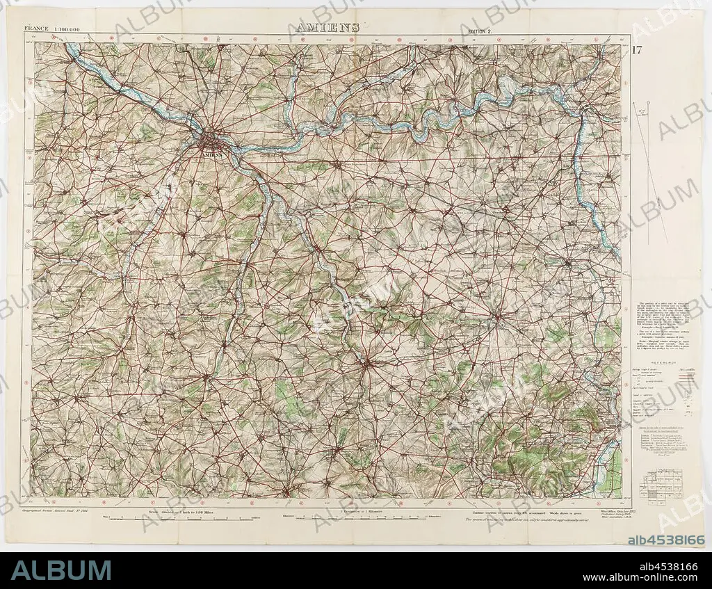
Map - Military, France, Amiens 17, Scale 1:100,000, Edition 2, World War I, 1 Oct 1916, World War I military map of Amiens, Sheet 17, France, scale 1:100,000, edition 2, published by the War Office in October 1915 from a 1915 Ordnance Survey, with 'minor corrections' dated 1 October 1916. The map is labelled Geographical Section, General Staff, No. 2364. Part of the collection of World War I memorabilia donated by Sergeant John Lord (#6252). John Lord was 19 years old when.
| Share |
|---|
 Pinterest Pinterest |
 Twitter Twitter |
 Facebook Facebook |
 Copy link Copy link |
 Email Email |
|
Add to another lightbox |
|
Add to another lightbox |


Buy this image.
Select the use:

Caption:
Map - Military, France, Amiens 17, Scale 1:100,000, Edition 2, World War I, 1 Oct 1916, World War I military map of Amiens, Sheet 17, France, scale 1:100,000, edition 2, published by the War Office in October 1915 from a 1915 Ordnance Survey, with 'minor corrections' dated 1 October 1916. The map is labelled Geographical Section, General Staff, No. 2364. Part of the collection of World War I memorabilia donated by Sergeant John Lord (#6252). John Lord was 19 years old when
Credit:
Album / quintlox
Releases:
Model: No - Property: No
Rights questions?
Rights questions?
Image size:
3900 x 3023 px | 33.7 MB
Print size:
33.0 x 25.6 cm | 13.0 x 10.1 in (300 dpi)
Keywords:
#6252 • 000 • 1 OCT 1916 • 100 • 19 YEARS OLD • 1915 ORDNANCE SURVEY • 1ST WORLD WAR • 2364 • AMIENS 17 • AMIENS • COLLECTION • EDITION 2 • FIRST WORLD WAR • FRANCE • GENERAL STAFF • JOHN LORD • LABELLED GEOGRAPHICAL SECTION • MAP • MAPS • MILITARY • MINOR CORRECTIONS' DATED 1 OCTOBER 1916 • NO • OCTOBER 1915 • OFFICERS' STAFF • PART • PLAN (CARTOGRAPHY) • PUBLISHED • SCALE 1 • SERGEANT JOHN LORD • SHEET 17 • WAR OFFICE • WORLD WAR I (1914-18) • WORLD WAR I MEMORABILIA DONATED • WORLD WAR I MILITARY MAP • WORLD WAR I • WORLD WAR ONE • WWI
