alb4282371
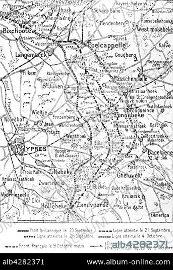
Map of the Frist Battle of 'Ypres
| Share |
|---|
 Pinterest Pinterest |
 Twitter Twitter |
 Facebook Facebook |
 Copy link Copy link |
 Email Email |
|
Add to another lightbox |
|
Add to another lightbox |


Buy this image.
Select the use:

Title:
Map of the Frist Battle of 'Ypres
Caption:
First World War. . Map of the Frist Battle of 'Ypres (September to October 1914) showing the Franco-British attack.
Credit:
Album / Photo12/Archives Snark
Releases:
Model: No - Property: No
Rights questions?
Rights questions?
Image size:
3446 x 5023 px | 49.5 MB
Print size:
29.2 x 42.5 cm | 11.5 x 16.7 in (300 dpi)
Keywords:
1ST WORLD WAR • 20TH CENTURY • BACELAERE • BATTLE OF FLANDERS • FIRST WORLD WAR • FRANCE • LANGELMARCK • MAP • POELCAPPELLE • WORLD WAR I (1914-18) • WORLD WAR I • WORLD WAR ONE • WW1 • WWI • ZONNEBEKE
