alb9843194
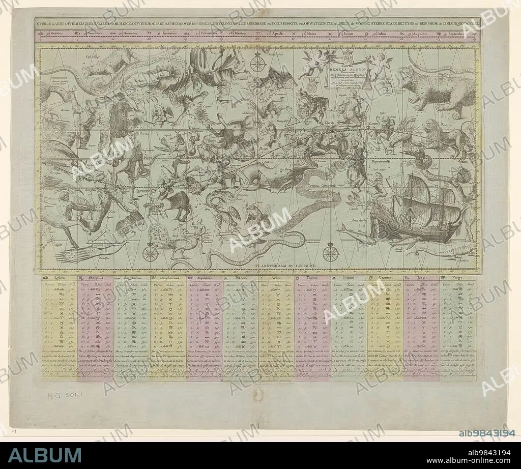
REMMET TEUNISSE BACKER, JOHANNES DE BROEN. Star chart or map of the heavens, 1684 and/or 1792. Creators: Remmet Teunisse Backer, Johannes de Broen.
| Share |
|---|
 Pinterest Pinterest |
 Twitter Twitter |
 Facebook Facebook |
 Copy link Copy link |
 Email Email |
|
Add to another lightbox |
|
Add to another lightbox |


Buy this image.
Select the use:

Author: REMMET TEUNISSE BACKER • JOHANNES DE BROEN
Title: Star chart or map of the heavens, 1684 and/or 1792. Creators: Remmet Teunisse Backer, Johannes de Broen.
Caption: Star chart or map of the heavens, 1684 and/or 1792. 'Door dit hemels pleyn wert vertoondt den gehelen loop des hemels der vaste sterren met haer beeltenisse'. (By this celestial pleyn wert, the whole course of heaven of the fixed stars with her image). Map of the constellations. The map is divided horizontally into 12 months from October. The lower 1/3 has the same division in twelve with the corresponding constellations and their important data: hours, signs, degrees. Bottom right the 'lost constellation' of the 'Noah's Ark'. The tables containing the data are coloured.
Personalities: JAN BAREND ELWE
Credit: Album / Heritage Art/Heritage Images
Releases: ? Model Release: No - ? Property Release: No
Rights questions?
Rights questions?
Image size: 5724 × 4860 px | 79.6 MB
Print size: 48.5 × 41.1 cm | 2253.5 × 1913.4 in (300 dpi)
Keywords: 17TH CENTURY • 18TH CENTURY • 18TH CENTURY, THE • 18TH CENTURY. • 18TH • ANIMAL • ANIMALS • ART • ARTS • ASTROLOGIA • ASTROLOGY • ASTRONOMIA • ASTRONOMY • B & W • B / W • B W • B&W • BACKER • BLACK & WHITE • BLACK AND WHITE • BROEN • CALENDAR • CENTURY • COLOR • COLOUR • CONSTELLATION • CONSTELLATIONS • DRAGON • DUTCH • EIGHTEENTH CENTURY • ENGRAVED • ENGRAVING • EUROPE • FLUSH • JAN BAREND ELWE • JOHANNES DE BROEN • JOHANNES DE RAM • JOHANNES DE • LOW COUNTRIES • MAP • MONSTER • MONSTERS • MUSEUM • MYTHICAL BEAST • MYTHICAL BEASTS • MYTHICAL CREATURE • MYTHICAL CREATURES • MYTHOLOGICAL CREATURE • MYTHOLOGY • NETHERLANDS • PAPER • PRINT • RAM • REMMET TEUNISSE BACKER • REMMET TEUNISSE • RIJKSMUSEUM • SCIENCE • SEVENTEENTH CENTURY • SIGN OF THE ZODIAC • SIGNS OF THE ZODIAC • STAR CHART • STARS • WATERCOLOUR (PAINT) • WATERCOLOUR • WHITE AND BLACK • XVIII CENTURY • ZODIAC SIGN • ZODIAC
