alb5391088
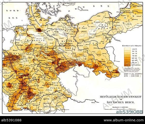
Historical map, population density in the German Reich, 19th Century, from Meyers Konversations-Lexikon encyclopaedia, 1890.
| Share |
|---|
 Pinterest Pinterest |
 Twitter Twitter |
 Facebook Facebook |
 Copy link Copy link |
 Email Email |
|
Add to another lightbox |
|
Add to another lightbox |


Buy this image.
Select the use:

Caption:
Historical map, population density in the German Reich, 19th Century, from Meyers Konversations-Lexikon encyclopaedia, 1890
Credit:
Album / ImageBroker / H.-D. Falkenstein
Releases:
Model: No - Property: No
Rights questions?
Rights questions?
Image size:
600 x 479 px | 842.0 KB
Print size:
5.1 x 4.1 cm | 2.0 x 1.6 in (300 dpi)
Keywords:
19TH CENTURY • AGE • ÂGÉS • AUS • CADRE • CARD • CARDBOARD • CARDS • CHARTS • COLORED • COLORFUL • COLOURED • COLOURFUL • DEPICTION • DEPICTIONS • DEUTSCHES REICH • DRAWING • DRAWINGS • ENCYCLOPEDIA • ENCYLOPEDIAS • GEOGRAPHIC • GEOGRAPHICAL • GEOGRAPHY • GERMAN REICH • GERMAN • GERMANS • HISTORIC • HISTORICAL • HISTORY • ILLUSTRATION • ILLUSTRATIONS • IMAGE MOTIF • IMAGES • IN PAINTINGS • INTERIORS: IN PAINTINGS • MAP • MAPS • MEYERS KONVERSATIONS-LEXIKON • MEYERS LEXIKON • MULTI COLORED • MULTI COLOURED • MULTI-COLORED • MULTI-COLOURED • MULTICOLORED • MULTICOLOURED • NINETEENTH CENTURY • OLD AGE • OLD • PAINTING (ACTIVITY) • PAINTING • PAINTINGS • PICTURE • PICTURES • REFERENCE BOOK • REFERENCE BOOKS • SKETCH • VARIEGATED
