alb3908109
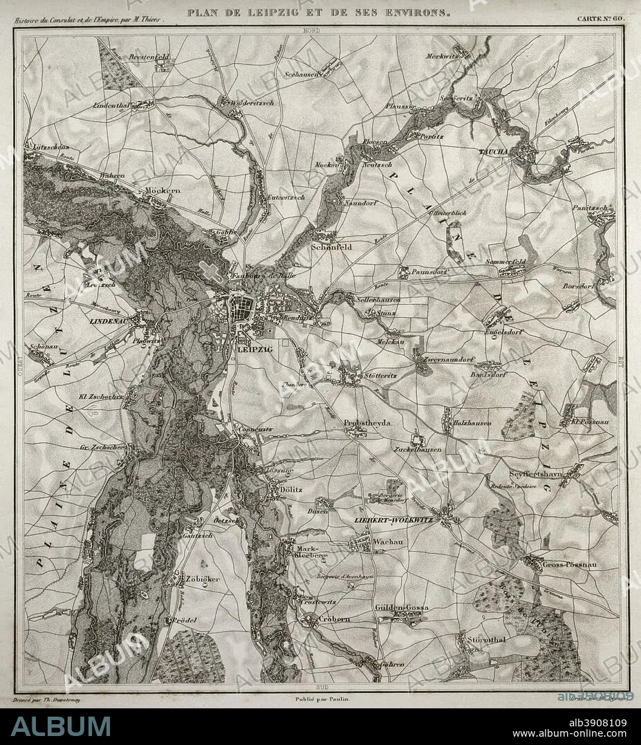
Napoleonic map. City of Leipzig, Saxony, Germany. The Battle of the Nations or Battle of Leipzig took place in 1813, In the context of the Napoleonic wars, being the first French defeat. Atlas de l'Histoire du Consulat et de l'Empire. History of the Consulate and the Empire of France under Napoleon by Marie Joseph Louis Adolphe Thiers (1797-1877). Drawings by Dufour, engravings by Dyonnet. Edited in Paris, 1864.
| Share |
|---|
 Pinterest Pinterest |
 Twitter Twitter |
 Facebook Facebook |
 Copy link Copy link |
 Email Email |
|
Add to another lightbox |
|
Add to another lightbox |


Buy this image.
Select the use:

Caption: Napoleonic map. City of Leipzig, Saxony, Germany. The Battle of the Nations or Battle of Leipzig took place in 1813, In the context of the Napoleonic wars, being the first French defeat. Atlas de l'Histoire du Consulat et de l'Empire. History of the Consulate and the Empire of France under Napoleon by Marie Joseph Louis Adolphe Thiers (1797-1877). Drawings by Dufour, engravings by Dyonnet. Edited in Paris, 1864.
Personalities: NAPOLÉON (1769-1821)
Credit: Album / Prisma
Releases: ? Model Release: No - ? Property Release: No
Rights questions?
Rights questions?
Image size: 3425 × 3784 px | 37.1 MB
Print size: 29.0 × 32.0 cm | 1348.4 × 1489.8 in (300 dpi)
Keywords: 16 • 16-19 OCTOBER • 1813 • 1864 • 19 CENTURY • 19 • 19TH CENTURY • 19TH CENTURY. • 19TH • 19TH-CENTURY • ADOLPHE THIERS • ALEXANDER I • ALEXANDER I. • ANCIENT • ANTIQUE • ATLANTE • ATLANTEAN • ATLAS DE L'HISTOIRE DU CONSULAT ET DE L'EMPIRE • ATLAS DE L'HISTORIE DU CONSULAT ET DE L'EMPIRE • ATLAS • AUSTRIA • AUSTRIAN • BATLLE OF LEIPZIG • BATTLE OF THE NATIONS • BATTLE • CARTOGRAPHY • CITY • COALITION VICTORY • COALITION • COMBAT • DEFEAT • DESIGNING • DEUTSCHLAND • DISPUTE • DRAWING • DRAWN • DUFOUR • DYONNET • EMPIRE • ENGRAVED • ENGRAVING (ARTWORK) • ENGRAVING • ENGRAVING. • ENGRAVINGS • ENVIRONS • ETCHING • EUROPA • EUROPE • EUROPEA • EUROPEAN • EUROPEANS • FIGHT • FIGHTING • FIRST FRENCH DEFEAT • FIRST FRENCH EMPIRE • FRANCE • FRANCE. • FRANÇAIS • FRENCH EMPIRE • FRENCH • GEOGRAFIA • GEOGRAPHICAL • GEOGRAPHY • GERMAN CAMPAIGN • GERMAN • GERMANS • GERMANY • GUERRA • HISTORIA UNIVERSAL • HISTORIA • HISTORIC • HISTORICAL • HISTORY OF THE CONSULATE AND THE EMPIRE OF FRANCE UNDER NAPOLEON • HISTORY OF THE CONSULATE AND THE NAPOLEON EMPIRE • HISTORY • HISTORY. • HUNDRED YEARS WAR • ILLUSTRATION • ILLUSTRATIONS • ILUSTRATION • KARL PHILIPP • LA FRANCE • LEIPZIG • LINDENAU • MAP MAKING • MAP • MAPS • MARIE JOSEPH LOUIS ADOLPHE THIERS • MODERN AGE • MODERN ERA • MODERN PERIOD • NAPOLEON I BONAPARTE • NAPOLEON I • NAPOLEON'S FRENCH EMPIRE • NAPOLEON • NAPOLEONIC EMPIRE • NAPOLEONIC INVASION • NAPOLEONIC MAP • NAPOLEONIC WAR • NAPOLEONIC WARS • NINETEENTH CENTURY • OCTOBER • OLD • PEACE, NAPOLEONIC WARS • PLAN (CARTOGRAPHY) • PLAN • PLANE • PRINT • PRUSIA • PRUSSIA • RUSIA • RUSSIA • SAXONY • SCUFFLE • STRUGGLE • SURFACE • SURROUNDING • SWEDEN • TERRITORY • THIERS • URBE • VILLAGE • WAR OF THE SIXTH COALITION • WAR • WARFARE • WARS • XIX CENTURY
