alb4478645
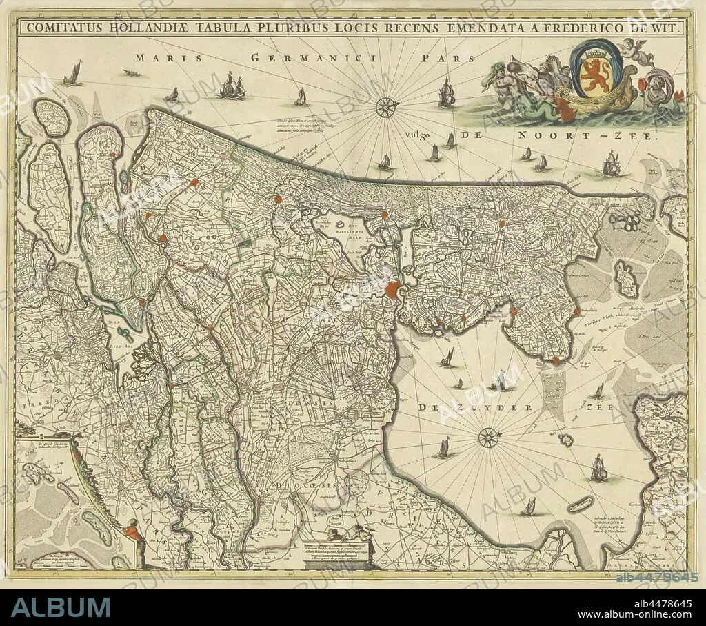
Map of county Holland, Comitatus Hollandiae tabula pluribus locis recens emendata (title on object), Map of the county of Holland on a scale of 1: 300 000, north on the right. Above right the weapon of Holland on a boat pulled by sea creatures. Bottom left a deployment with the Wadden Islands Texel, Vlieland, Terschelling and part of Ameland, maps of separate countries or regions, Holland, Noord-Holland, Zuid-Holland, Frederik de Wit (mentioned on object), c. 1670, paper, engraving, h 463 mm × w 563 mm.
| Share |
|---|
 Pinterest Pinterest |
 Twitter Twitter |
 Facebook Facebook |
 Copy link Copy link |
 Email Email |
|
Add to another lightbox |
|
Add to another lightbox |


Caption:
Map of county Holland, Comitatus Hollandiae tabula pluribus locis recens emendata (title on object), Map of the county of Holland on a scale of 1: 300 000, north on the right. Above right the weapon of Holland on a boat pulled by sea creatures. Bottom left a deployment with the Wadden Islands Texel, Vlieland, Terschelling and part of Ameland, maps of separate countries or regions, Holland, Noord-Holland, Zuid-Holland, Frederik de Wit (mentioned on object), c. 1670, paper, engraving, h 463 mm × w 563 mm
Credit:
Album / quintlox
Releases:
Model: No - Property: No
Rights questions?
Rights questions?
Image size:
5359 x 4468 px | 68.5 MB
Print size:
45.4 x 37.8 cm | 17.9 x 14.9 in (300 dpi)
Keywords:
1 • 1670 • 300 000 • AMELAND • ARMS • BOAT PULLED • BOTTOM LEFT • C • COMITATUS HOLLANDIAE TABULA PLURIBUS LOCIS RECENS EMENDATA • COUNTY HOLLAND • COUNTY • DEPLOYMENT • ENGRAVED • ENGRAVING (ARTWORK) • ENGRAVING • ENGRAVING. • ENGRAVINGS • ETCHING • FREDERIK DE WIT • HOLLAND • MAP • MAPS • MENTIONED • NOORD-HOLLAND • NORDEN • NORTH • OBJECT • OBJECTS • PAPER AND PACKAGE PRODUCTS • PAPER • PART • PLAN (CARTOGRAPHY) • PRINT • REGIONS • RIGHT • SCALE • SEA CREATURES • SEPARATE COUNTRIES • TERSCHELLING • TITLE • UMBRELLA • VLIELAND • WADDEN ISLANDS TEXEL • WEAPON • WEAPONRY • WEAPONS • ZUID-HOLLAND
