alb3908098
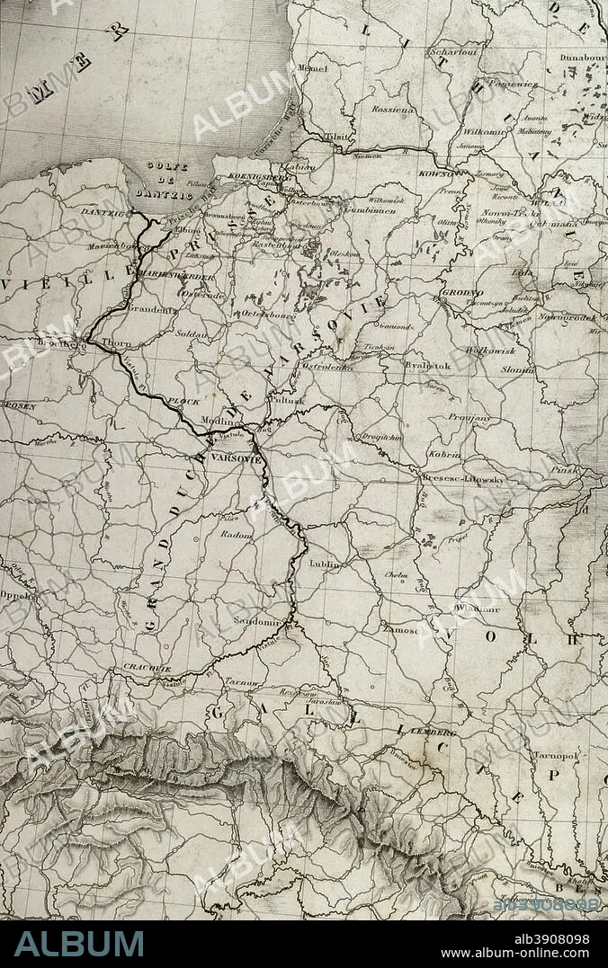
Napoleonic map. European Russia, detail. Area of the Baltic Sea and the territory of Duchy of Warsaw. Atlas de l'Histoire du Consulat et de l'Empire. History of the Consulate and the Empire of France under Napoleon by Marie Joseph Louis Adolphe Thiers (1797-1877). Drawings by Dufour, engravings by Dyonnet. Edited in Paris, 1864.
| Share |
|---|
 Pinterest Pinterest |
 Twitter Twitter |
 Facebook Facebook |
 Copy link Copy link |
 Email Email |
|
Add to another lightbox |
|
Add to another lightbox |


Buy this image.
Select the use:

Caption:
Napoleonic map. European Russia, detail. Area of the Baltic Sea and the territory of Duchy of Warsaw. Atlas de l'Histoire du Consulat et de l'Empire. History of the Consulate and the Empire of France under Napoleon by Marie Joseph Louis Adolphe Thiers (1797-1877). Drawings by Dufour, engravings by Dyonnet. Edited in Paris, 1864.
Personalities:
Credit:
Album / Prisma
Releases:
Model: No - Property: No
Rights questions?
Rights questions?
Image size:
3273 x 4957 px | 46.4 MB
Print size:
27.7 x 42.0 cm | 10.9 x 16.5 in (300 dpi)
Keywords:
1864 • 19 CENTURY • 19TH CENTURY • 19TH CENTURY. • 19TH • 19TH-CENTURY • ADOLPHE THIERS • ANCIENT • ANTIQUE • ATLANTE • ATLANTEAN • ATLAS DE L'HISTOIRE DU CONSULAT ET DE L'EMPIRE • ATLAS DE L'HISTORIE DU CONSULAT ET DE L'EMPIRE • ATLAS • AUTHOR • BALTIC SEA • BALTICA • CAMPAIGN • CARTOGRAPHY • COAST • COASTAL • COASTLINE • COMMUNISM: POLAND • CONSULATE, THE • CRACOVIA • CRACOW • DANTZIG • DANZIG • DESIGNING • DRAWING • DRAWN • DUCHY OF WARSAW • DUCHY • DUFOUR • DYONNET • EMPIRE • ENGRAVED • ENGRAVING (ARTWORK) • ENGRAVING • ENGRAVING. • ENGRAVINGS • ESTONIA • ETCHING • EUROPA • EUROPE • EUROPEA • EUROPEAN RUSSIA • EUROPEAN • EUROPEANS • FINLAND • FIRST FRENCH EMPIRE • FRANCE • FRANCE. • FRANÇAIS • FRENCH EMPIRE • FRENCH • GDANSK • GEOGRAFIA • GEOGRAPHICAL • GEOGRAPHY • GOTHLAND • GOTLAND • GOTTLAND • GRODNO • GULF • HISTORIA UNIVERSAL • HISTORIA • HISTORIC • HISTORICAL • HISTORY OF THE CONSULATE AND THE EMPIRE OF FRANCE UNDER NAPOLEON • HISTORY OF THE CONSULATE AND THE NAPOLEON EMPIRE • HISTORY • HISTORY. • HRODNA • ILLUSTRATION • ILLUSTRATIONS • INCURSION • INVASION • LA FRANCE • LITHUANIA • MAP MAKING • MAP • MAPS • MARIE JOSEPH LOUIS ADOLPHE THIERS • MARITIME • MINSK • MODERN AGE • MODERN ERA • MODERN PERIOD • NAPOLEON I BONAPARTE • NAPOLEON I • NAPOLEON'S FRENCH EMPIRE • NAPOLEON • NAPOLEONIC EMPIRE • NAPOLEONIC ERA • NAPOLEONIC INVASION • NAPOLEONIC PERIOD • NINETEENTH CENTURY • OLD • PLAN (CARTOGRAPHY) • PLAN • PLANE • PLOCK • POLAND • POLAND: COMMUNISM • POLAND: POSTWAR • POSTWAR: POLAND • PRINT • RIGA • RUSIA • RUSSIA • RUSSIAN CAMPAIGN • RUSSIAN EMPIRE • RUSSIAN • SEASHORE • SEASIDE • SHORELINE • SWEDEN • TERRITORY • THIERS • VILNA • VILNIUS • WARSAW • XIX CENTURY
