alb3988176
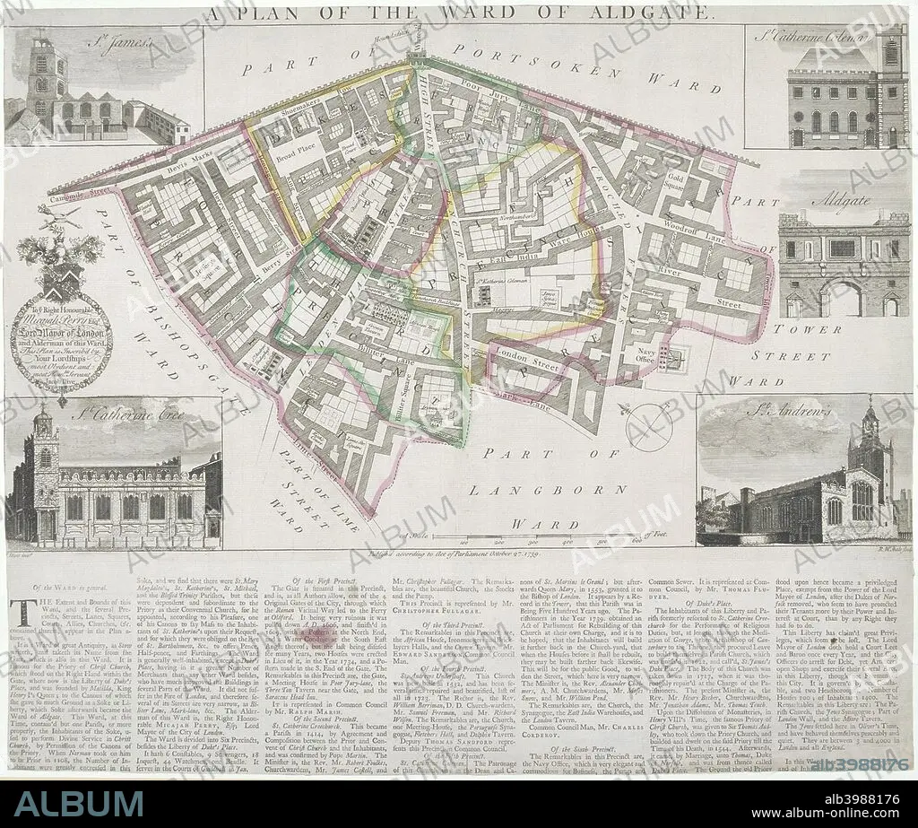
Map of Aldgate Ward, City of London, 1739. Artist: RW Seale
| Share |
|---|
 Pinterest Pinterest |
 Twitter Twitter |
 Facebook Facebook |
 Copy link Copy link |
 Email Email |
|
Add to another lightbox |
|
Add to another lightbox |


Buy this image.
Select the use:

Title: Map of Aldgate Ward, City of London, 1739. Artist: RW Seale
Caption: Map of Aldgate Ward, City of London, 1739. With images in the margins of Aldgate and four ward churches: St James, Duke Street, St Katherine Cree, St Katherine Coleman and St Andrew Undershaft. Below is a description of the ward.
Personalities: JACOB
Credit: Album / The London Archives (City of London)/Heritage Images
Releases: ? Model Release: No - ? Property Release: No
Rights questions?
Rights questions?
Image size: 2718 × 2310 px | 18.0 MB
Print size: 23.0 × 19.6 cm | 1070.1 × 909.4 in (300 dpi)
Keywords: 18TH CENTURY • 18TH CENTURY, THE • 18TH CENTURY. • 18TH • ALDGATE • ARCHITECTURE • BRITAIN • BRITISH • BUILDING • BUILDINGS • CENTURY • CHRISTIAN • CHRISTIANISM • CHRISTIANITY • CHURCH TOWER • CHURCH • CHURCHES • CITY OF LONDON • COLOR • COLOUR • COUNTRY • CRISTIANDAD • CRISTIANISMO • DUKE STREET • ECCLESIA • EIGHTEENTH CENTURY • ENGLAND • ENGLISH • ENGRAVING • EXTERIOR • FLUSH • GATE • GUILDHALL LIBRARY & ART GALLERY • IGLESIA • JACOB ILIVE; ILIVE • JACOB • LOCATION • MAP • OUTSIDE • RELIGION • RELIGIOUS • RW SEALE • RW • SEALE • ST ANDREW UNDERSHAFT • ST JAMES • ST KATHERINE COLEMAN RECTORY • ST KATHERINE CREE • ST. JAMES • WARD • XVIII CENTURY
