alb9215449
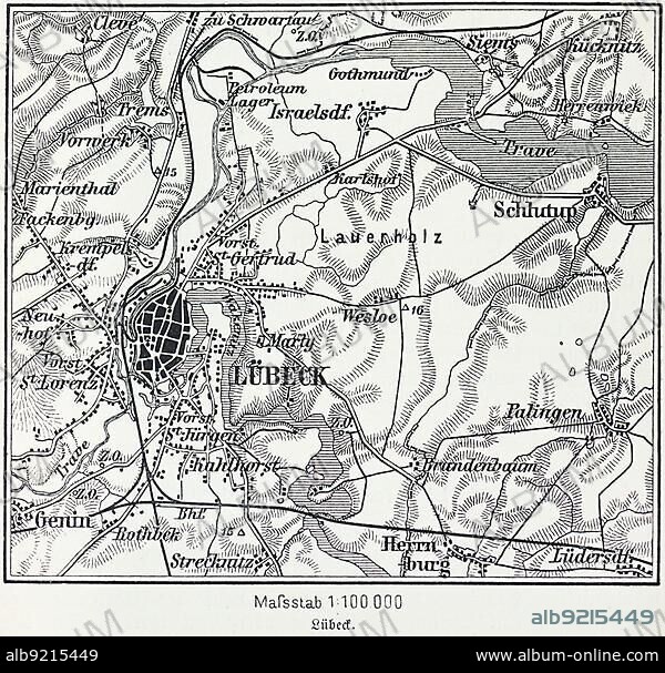
City map of Lübeck, Hanseatic city, Schleswig-Holstein, Germany, Trave, Baltic Sea, districts, Schlutup, St. Lorenz, map, cartography, railway lines, surrounding area, historical illustration 19th century, Europe.
| Share |
|---|
 Pinterest Pinterest |
 Twitter Twitter |
 Facebook Facebook |
 Copy link Copy link |
 Email Email |
|
Add to another lightbox |
|
Add to another lightbox |


Buy this image.
Select the use:

Caption:
City map of Lübeck, Hanseatic city, Schleswig-Holstein, Germany, Trave, Baltic Sea, districts, Schlutup, St. Lorenz, map, cartography, railway lines, surrounding area, historical illustration 19th century, Europe
Credit:
Album / ImageBroker / Wolfgang Diederich
Releases:
Model: No - Property: No
Rights questions?
Rights questions?
Image size:
600 x 574 px | 1009.0 KB
Print size:
5.1 x 4.9 cm | 2.0 x 1.9 in (300 dpi)
Keywords:
19 CENTURY • 1900S • 1990S • 19TH CENTURY • 19TH • 19TH-CENTURY • 90S • BALTIC SEA • BUILDING • BUILDINGS • CENTRAL EUROPE • CHURCH BUILDING • CHURCH • CHURCHES • CITIES • CITY MAP • CITY MAPS • CITY • DESERTED • ECCLESIA • EMPTY • EUROPE'S • EUROPE • FRG • GEOGRAPHIC • GEOGRAPHICAL • GEOGRAPHY • GERMAN FEDERAL REPUBLIC • GERMAN • GERMANS • GERMANY • HANSEATIC CITIES • HANSEATIC CITY • HANSEATIC TOWN • HISTORIC ILLUSTRATION • HISTORIC ILLUSTRATIONS • HISTORIC • HISTORICAL ILLUSTRATION • HISTORICAL • HISTORY • ILLUSTRATION • ILLUSTRATIONS • LAND SCHLESWIG-HOLSTEIN • LORENZKIRCHE • LUEBECK • LÜBECK • MAP • MAPS • MIDDLE EUROPE • MUNICIPAL • NAVIGATION • NINETEENTH CENTURY • NINETIES • NINETIES, THE • NINETY DECADE • NO ONE • NO PEOPLE • NO-ONE • NOBODY • NORTH GERMANY • NORTHERN GERMANY • ORIENTATION • RELIGION • RELIGIOUS BUILDING • RELIGIOUS BUILDINGS • RELIGIOUS • REPUBLIC OF GERMANY • RIVER TRAVE • RIVER • RIVERS • SACRAL BUILDING • SACRED BUILDING • SACRED STRUCTURES • SCHLESWIG-HOLSTEIN • SEA • ST. LAWRENCE • ST. LORENZ • STRUCTURE • TOWN • TRAVE • UNINHABITED • URBAN ENVIRONMENT • URBAN • WITHOUT PEOPLE • XIX CENTURY
