alb4859777
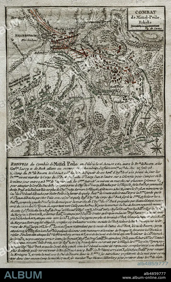
JEAN DE BEAURAIN (1696-1771). FRENCH GEOGRAPHER.. Seven Years War (1756-1763). Battle of Reichenbach (August 16, 1762). Map of Mittel Peile, 1762. Silesia. Austrian troops led by Marshal Daun attacked the Prussian army, which was able to resist the offensive. Published in 1765 by the cartographer Jean de Beaurain (1696-1771) as an illustration of his Great Map of Germany, with the events that took place during the Seven Years War. Etching and engraving. French edition, 1765. Military Historical Library of Barcelona (Biblioteca Histórico Militar de Barcelona). Catalonia. Spain.
| Share |
|---|
 Pinterest Pinterest |
 Twitter Twitter |
 Facebook Facebook |
 Copy link Copy link |
 Email Email |
|
Add to another lightbox |
|
Add to another lightbox |


Buy this image.
Select the use:

Caption: Seven Years War (1756-1763). Battle of Reichenbach (August 16, 1762). Map of Mittel Peile, 1762. Silesia. Austrian troops led by Marshal Daun attacked the Prussian army, which was able to resist the offensive. Published in 1765 by the cartographer Jean de Beaurain (1696-1771) as an illustration of his Great Map of Germany, with the events that took place during the Seven Years War. Etching and engraving. French edition, 1765. Military Historical Library of Barcelona (Biblioteca Histórico Militar de Barcelona). Catalonia. Spain.
Location: Historical Military Library of Barcelona. Catalonia. Spain.
Credit: Album / Prisma
Releases: ? Model Release: No - ? Property Release: No
Rights questions?
Rights questions?
Image size: 3248 × 5083 px | 47.2 MB
Print size: 27.5 × 43.0 cm | 1278.7 × 2001.2 in (300 dpi)
Keywords: 16 AUGUST 1762 • 1762 • 1765 • 18 CENTURY • 18TH CENTURY • 18TH CENTURY, THE • 18TH CENTURY. • 18TH • ANCIENT • ANTIQUE • ARMY, PRUSSIAN • AUGUST 16 • AUSTRIAN ARMY • BATTLE OF REICHENBACH • BATTLE REPRESENTATION • BATTLE • BATTLEFIELD • BATTLEGROUND • CARTOGRAPHY • COMBAT • COMBATTIMENTO • DAUN • DEUTSCHLAND • DISPUTE • EIGHTEENTH CENTURY • ENGRAVED • ENGRAVING (ARTWORK) • ENGRAVING • ENGRAVING. • ENGRAVINGS • ETCHING • EUROPA • EUROPE • FIGHT • FIGHTING • GERMANY HISTORY • GERMANY • GREAT MAP OF GERMANY • GUERRA • HISTORIA DE ALEMANIA • HISTORIA UNIVERSAL • HISTORIA • HISTORICAL MILITARY LIBRARY OF BARCELONA. CATALONIA. SPAIN. • HISTORY AUSTRIA • HISTORY OF AUSTRIA • HISTORY OF GERMANY • HISTORY OF PRUSSIA • HISTORY PRUSSIA • HISTORY • HISTORY, PRUSSIA • HISTORY. • HUNDRED YEARS WAR • INTERNATIONAL CONFLICT • JEAN DE BEAURAIN (1696-1771). FRENCH GEOGRAPHER. • JEAN DE BEAURAIN • MAP MAKING • MAP • MAPS • MARSHAL DAUN • MILITARY STRATEGY • MILITARY TACTIC • MILITARY TACTICS • MITTEL PEILAU • MITTEL PEILE • MITTEL-PEILE • MODERN AGE • MODERN ERA • MODERN PERIOD • OLD MAP • OLD • PEILAU • PEILE • PLAN (CARTOGRAPHY) • PRINT • PRUSSIA, HISTORY • PRUSSIAN ARMY • REICHENBACH • SCUFFLE • SEVEN YEARS WAR • SEVEN YEARS' WAR • SILESIA • SILESIAN WAR • STRATEGY • STRUGGLE • TACTIC • TACTICS • WAR • WAR, SEVEN YEARS • WAR, SILESIAN • WARFARE • WARS • XVIII CENTURY
