alb3897638
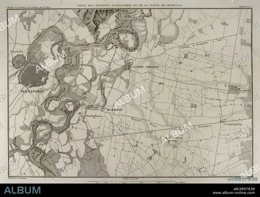
Map of the surroundings of Alessandria della Paglia and the plain of Marengo (Italian Piedmont). In this area took place the Battle of Marengo in 1800, during the War of the Second Coalition, between French and Austrian troops. Atlas de l'Histoire du Consulat et de l'Empire. History of the Consulate and the Empire of France under Napoleon by Marie Joseph Louis Adolphe Thiers (1797-1877). Drawings by Dufour, engravings by Dyonnet. Edited in Paris, 1864.
| Share |
|---|
 Pinterest Pinterest |
 Twitter Twitter |
 Facebook Facebook |
 Copy link Copy link |
 Email Email |
|
Add to another lightbox |
|
Add to another lightbox |


Caption:
Map of the surroundings of Alessandria della Paglia and the plain of Marengo (Italian Piedmont). In this area took place the Battle of Marengo in 1800, during the War of the Second Coalition, between French and Austrian troops. Atlas de l'Histoire du Consulat et de l'Empire. History of the Consulate and the Empire of France under Napoleon by Marie Joseph Louis Adolphe Thiers (1797-1877). Drawings by Dufour, engravings by Dyonnet. Edited in Paris, 1864.
Personalities:
Credit:
Album / Prisma
Releases:
Model: No - Property: No
Rights questions?
Rights questions?
Image size:
4961 x 3505 px | 49.7 MB
Print size:
42.0 x 29.7 cm | 16.5 x 11.7 in (300 dpi)
Keywords:
1800 • 1864 • 19 CENTURY • 19TH CENTURY • 19TH • 19TH-CENTURY • ADOLPHE THIERS • ALESSANDRIA DELLA PAGLIA • ALESSANDRIA • ALEXANDRIE • ANCIENT CARTOGRAPHY • ANCIENT • ANTIQUE • ATLANTE • ATLANTEAN • ATLAS DE L'HISTOIRE DU CONSULAT ET DE L'EMPIRE • ATLAS • AUSTRIA • AUSTRIAN • AUSTRIANS • BATTLE OF MARENGO • BATTLE • BATTLEFIELD • CARTOGRAPHY • CARTOONIST • CITY • COMBAT • CONSULATE • DESIGNING • DISPUTE • DRAWING • DRAWN • DUFOUR • DYONNET • EDITION • EMPIRE • ENGRAVED • ENGRAVING (ARTWORK) • ENGRAVING • ENGRAVING. • ENGRAVINGS • ETCHING • EUROPA • EUROPE • EUROPEA • EUROPEAN • EUROPEANS • FIGHT • FIGHTING • FIRST FRENCH EMPIRE • FLUVIAL • FRANCE • FRANÇAIS • FRENCH EMPIRE • FRENCH • GEOGRAPHICAL • GEOGRAPHY • GRAPH • HISTORIA UNIVERSAL • HISTORIA • HISTORIC • HISTORICAL • HISTORY OF THE CONSULATE AND THE EMPIRE OF FRANCE UNDER NAPOLEON • HISTORY OF THE CONSULATE AND THE NAPOLEON EMPIRE • HISTORY • HUNDRED YEARS WAR • ITALIA • ITALIAN PIEDMONT • ITALIAN • ITALY • LAMINA • MAP MAKING • MAP • MAP-MAKING • MAPS • MARENGO • MARIE JOSEPH LOUIS ADOLPHE THIERS • NAPOLEON I • NAPOLEON'S FRENCH EMPIRE • NAPOLEON • NAPOLEONIC MAP • NINETEENTH CENTURY • OLD • PIEDMONT • PLAIN (PLATEAU) • PLAIN • PLAN (CARTOGRAPHY) • PLAN • PLANE • PLATEAU • PRINT • RIVER • SCUFFLE • SECOND COALITION • SHEET • SOLDIER • STREAM • STRUGGLE • SURROUNDING • TANARO RIVER • TANARO • TERRITORY • THIERS • TROOPS • URBE • VILLAGE • WAR OF THE SECOND COALITION • WAR • WARFARE • WARS • XIX CENTURY
