alb5529632
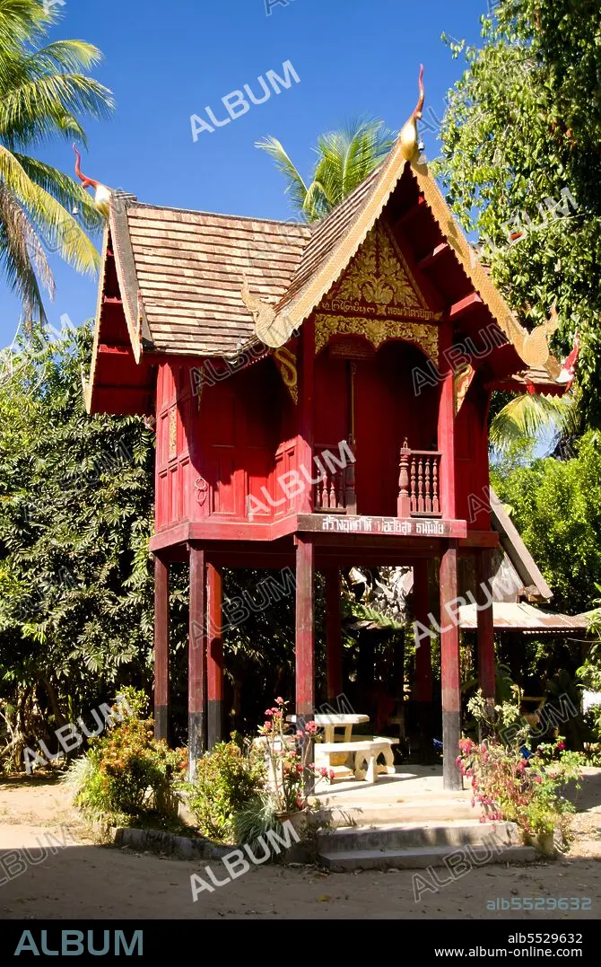
Thailand: Ho trai (scripture library), Wat Puttha En, Mae Chaem, Chiang Mai Province.
| Share |
|---|
 Pinterest Pinterest |
 Twitter Twitter |
 Facebook Facebook |
 Copy link Copy link |
 Email Email |
|
Add to another lightbox |
|
Add to another lightbox |


Title:
Thailand: Ho trai (scripture library), Wat Puttha En, Mae Chaem, Chiang Mai Province.
Caption:
Wat Puttha En (???????????) is a typically northern Thai-style temple, established in 1868. It is chiefly remarkable for its small, wooden bot nam (????????) or ordination hall, built atop pillars in the centre of a square lotus pond. Such ‘water chapels’ are rare across Thailand. The newly renovated viharn is attractive but unremarkable, but behind, on etiolated red wooden piles, stands a northern-style ho trai (scripture library), decorated with red and gold lai kram patterns. Tucked away in a narrow valley, Mae Chaem (???????) must rank as one of the least accessible corners of Chiang Mai. Located on the westernmost frontier of the province, it is isolated from the main Chiang Mai valley by the East Thanon Thongchai Range dominated by Doi Inthanon (???????????; at 2,565m Thailand’s highest mountain), and from neighbouring Mae Hong Son province to the west by the Central Thanon Thongchai Range, including Doi Khun Bong (????????; 1,772m).
Credit:
Album / David Henley/Pictures from History/Universal Images Group
Releases:
Model: No - Property: No
Rights questions?
Rights questions?
Image size:
3271 x 4999 px | 46.8 MB
Print size:
27.7 x 42.3 cm | 10.9 x 16.7 in (300 dpi)
Keywords:
ABBEY • ARCHITECTURAL • ARCHITECTURE • ASIA PICTURES • ASIA • ASIAN IMAGE • ASIAN IMAGES • ASIAN PICTURES • ASIAN • BUDDHISM • BUDDHISM, BHUTANESE • BUDDHIST • CHIANG MAI • CHIANGMAI • CHIENGMAI • CLOISTER • CONVENT • CULT, BUDDHIST • DAVID HENLEY • HISTORIA UNIVERSAL • HISTORIA • HISTORICAL IMAGES • HISTORICAL PICTURES • HISTORICAL • HISTORY IMAGES • HISTORY PICTURES • HISTORY • HO TRAI • LAN NA KINGDOM • LAN NA • LANNA • LIBRARIES • LIBRARY • MAE CHAEM • MONASTERIES • MONASTERY • RELIGION • TEMPERA • TEMPLE • TEMPLES • THAI • THAILAND • THERAVADA
