alb3845103
Tsunami Map, Great Alaskan Earthquake, 1964
| Share |
|---|
 Pinterest Pinterest |
 Twitter Twitter |
 Facebook Facebook |
 Copy link Copy link |
 Email Email |
|
Add to another lightbox |
|
Add to another lightbox |


Title:
Tsunami Map, Great Alaskan Earthquake, 1964
Caption:
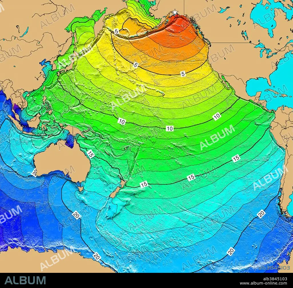
March 28, 1964 Prince William Sound, Alaska. This magnitude 9.2 Mw earthquake and ensuing tsunami caused 125 deaths and $311 million in property loss ($84 million and 106 deaths in Alaska). It was felt over a large area of Alaska and in parts of western Yukon Territory and British Columbia, its effects were heaviest in south central Alaska. The duration of the shock was estimated at 3 minutes. Vertical displacement occurred over 525,000 square km. About 20 landslide tsunamis were generated; the tectonic tsunami devastated many towns along the Gulf of Alaska, left serious damage in British Columbia, Hawaii, and along the west coast of the U.S. (15 killed), and was recorded on tide gages in Cuba and Puerto Rico. Map generated using Tsunami Travel Time (TTT) software: calculates first-arrival travel times on a grid for a tsunami generated at an earthquake epicenter. Map contours: 1 hour intervals: red 1-4 hour arrival times, yellow: 5-6 hour arrival times, green: 7-14 hour arrival times, blue: 15-21 hour arrival times. Maps were generated from earthquake epicenters in the NGDC Global Historical Tsunami Database using NGDC 2 Minute Gridded Global Relief Data bathymetry. Maps do not provide the height or the strength of the wave, only the arrival times.
Credit:
Album / NOAA/Science Source
Releases:
Model: No - Property: No
Rights questions?
Rights questions?
Image size:
3900 x 3632 px | 40.5 MB
Print size:
33.0 x 30.8 cm | 13.0 x 12.1 in (300 dpi)
Keywords:
1960S • 1964 • 2 MINUTE GRIDDED GLOBAL RELIEF DATA • 20 XX TWENTIETH CENTURY • 20TH CENTURY • 20TH • 60 60'S DECADE SIXTY YEARS • 60 60'S DECADE YEARS SIXTY SIXTIES • 60S • ALASKA • ALASKAN • ARRIVAL TIME • BATHYMETRIC • BATHYMETRY • CELEBRITIES • CELEBRITY • CHART • CONTOUR • EARTH SCIENCE • EARTHQUAKE EPICENTER • EARTHQUAKE • EVENT • EVENTS • FAMOUS • FLEET • GEOLOGIA • GEOLOGIC HAZARD • GEOLOGICAL • GEOLOGY • GEOPHYSICAL • GLOBAL HISTORICAL TSUNAMI DATABASE • GOOD FRIDAY EARTHQUAKE • GREAT ALASKAN EARTHQUAKE • HISTORIC • HISTORICAL • HISTORY • HYDROGRAPHIC • HYDROGRAPHY • IMPORTANT • MAP • MARCH 28 • MARCH 28TH • MARINE • MEGA-THRUST EARTHQUAKE • MEGATHRUST EARTHQUAKE • NATIONAL CENTERS FOR ENVIRONMENTAL INFORMATION • NATIONAL GEOPHYSICAL DATA CENTER • NATIONAL OCEANIC AND ATMOSPHERIC ADMINISTRATION • NATURAL DISASTER • NAVY • NCEI • NGDC • NOAA • NOTABLE • OCEAN DEPTH • OCEAN • PACIFIC • PHENOMENA • PHENOMENON • PORTAGE EARTHQUAKE • SEA • SEAS • SEISMIC • SEISMOLOGICAL • SEISMOLOGY • SIXTIES • SIXTIES, THE • TECHNOLOGICAL • TECHNOLOGY • TRAVEL TIME • TSUNAMI TRAVEL TIME • TSUNAMI WAVES • TSUNAMI • TTT • TWENTIETH CENTURY • WELL-KNOWN • YEARS DECADE'S SIXTY SIXTIES 60 60 1960
