alb3826047
Hurricane Wilma, 2005
| Share |
|---|
 Pinterest Pinterest |
 Twitter Twitter |
 Facebook Facebook |
 Copy link Copy link |
 Email Email |
|
Add to another lightbox |
|
Add to another lightbox |


Buy this image.
Select the use:

Title: Hurricane Wilma, 2005
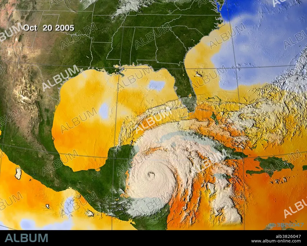
Caption: Ocean temperatures surrounding Wilma are hovering near 85 degrees F, about three degrees higher than the temperature required to fuel a hurricane. This image shows the sea surface temperatures (SSTs) from Oct. 15 - 20. Every area in yellow, orange or red represents temperatures of 82 degrees F or above. The data came from the Advanced Microwave Scanning Radiometer (AMSR-E) instrument on NASA's Aqua satellite. Hurricane Wilma was the most intense tropical cyclone ever recorded in the Atlantic basin. Part of the record breaking 2005 Atlantic hurricane season, which included three of the six most intense Atlantic hurricanes ever (along with #4 Rita and #6 Katrina), Wilma was the 22nd storm, 13th hurricane, 6th major hurricane, 4th Category 5 hurricane, and 2nd most destructive hurricane of the 2005 season. A tropical depression formed in the Caribbean Sea near Jamaica on October 15, and intensified into a tropical storm two days later, which was named Wilma. After heading westward as a tropical depression, Wilma turned abruptly southward after becoming a tropical storm. Wilma continued intensifying, and eventually became a hurricane on October 18. Shortly thereafter, extreme intensification occurred, and in only 24 hours, Wilma became a Category 5 hurricane with winds of 185 mph. Wilma is ranked among the top five most costly hurricanes ever recorded in the Atlantic and the fifth costliest storm in United States history.
Category: WEATHER
Credit: Album / NASA/Science Source
Releases: ? Model Release: No - ? Property Release: No
Rights questions?
Rights questions?
Image size: 4200 × 3150 px | 37.9 MB
Print size: 35.6 × 26.7 cm | 1653.5 × 1240.2 in (300 dpi)
Keywords: 2005 ATLANTIC HURRICANE SEASON • 2005 • 21ST CENTURY • 21ST • 21TH CENTURY • ADVANCED MICROWAVE SCANNING RADIOMETER • AMERICA • AMERICAN • AMSR-E INSTRUMENT • AQUA SATELLITE • ATLANTIC BASIN • ATLANTIC HURRICANE • ATMOSPHERIC CONDITIONS • ATMOSPHERIC • CATEGORY 5 • COSTLY • DEADLY • EARTH FROM SPACE • EARTH SCIENCE • GEOGRAFIA • GEOGRAPHIC • GEOGRAPHICAL • GEOGRAPHY • HISTORIC • HISTORICAL • HISTORY • HURRICANE WILMA • INTENSE • METEOROLOGICAL • METEOROLOGY • METEOROLOGY • NASA • NATURAL PHENOMENA • NATURAL PHENOMENON • OCEAN TEMPERATURE • OCTOBER 20 • OCTOBER 20TH • RADIOMETER • SATELLITE IMAGERY • SCIENCE • SEA SURFACE TEMPERATURE • SÉVÈRE • STORM • STRONG WEATHER • TOPOGRAPHICAL • TOPOGRAPHY • TROPICAL CYCLONE • TROPICAL HURRICANE • TROPICAL STORM • UNITED STATES • US • USA • VIOLENT • WEA • WEATHER EVENT • WEATHER • WEATHER: WEA
