alb2994765
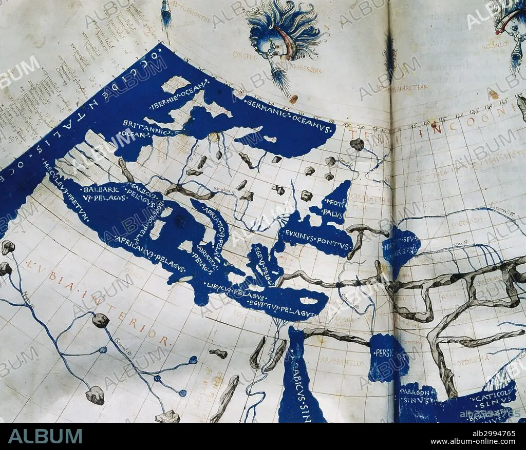
Manuscript copy of the Ptolemy (100-170 AD) world map, reconstituted from Ptolemy's Geography (c.150), indicating the countries of "Serica" and "Sinae" (China) at the extreme east, beyond the island of "Taprobane" (Sri Lanka, oversized) and the "Aurea Chersonesus" (Malay Peninsula). 15th-century.
| Share |
|---|
 Pinterest Pinterest |
 Twitter Twitter |
 Facebook Facebook |
 Copy link Copy link |
 Email Email |
|
Add to another lightbox |
|
Add to another lightbox |


Buy this image.
Select the use:

Caption: Manuscript copy of the Ptolemy (100-170 AD) world map, reconstituted from Ptolemy's Geography (c.150), indicating the countries of "Serica" and "Sinae" (China) at the extreme east, beyond the island of "Taprobane" (Sri Lanka, oversized) and the "Aurea Chersonesus" (Malay Peninsula). 15th-century.
Personalities: GRECO-EGYPTIAN
Credit: Album / Prisma
Releases: ? Model Release: No - ? Property Release: No
Rights questions?
Rights questions?
Image size: 5123 × 4121 px | 60.4 MB
Print size: 43.4 × 34.9 cm | 2016.9 × 1622.4 in (300 dpi)
Keywords: 15 15TH XV XVTH FIFTEENTH CENTURY • 150 • 15TH CENTURY • 15TH CENTURY; • 15TH • 2ND CENTURY A. D. • 2ND CENTURY AD • 2ND CENTURY • ALEXANDRIAN SCHOOL • ANCIENT AGE • ANCIENT CARTOGRAPHY • ANCIENT HISTORY • ANCIENT WORLD • ANCIENT • ANTIGUEDAD • ANTIQUE • ANTIQUITIES • ANTIQUITY • ASIA • ASTROLOGER • ASTRONOMER • ASTRONOMIA • ASTRONOMY • AUREA CHERSONESUS • BARTOLOMEO • BROOK • CARTOGRAPHY • CLAUDIUS PTOLEMY • EGYPT • EGYPTIAN • EGYPTIANS • ENGRAVED • ENGRAVING (ARTWORK) • ENGRAVING • ENGRAVING. • ENGRAVINGS • ETCHING • EUROPA • EUROPE • FIFTEENTH CENTURY • GEOGRAFIA • GEOGRAPHER • GEOGRAPHY • GRECO-EGYPTIAN • HISTORIA UNIVERSAL • HISTORIA • HISTORIC • HISTORICAL • HISTORY • HISTORY. • ISLA • ISLAND • ISLANDS • LUXOR • MALAY PENINSULA • MANUSCRIPT • MANUSCRIPTS • MAP MAKING • MAP OF THE WORLD • MAP • MAPS • MATHEMATICAL • MATHEMATICIAN • MEDITERRANEAN SEA • MEDITERRANEAN • MYTH: PERSIAN • NORTH AFRICA • NORTH OF AFRICA • OLD MAP • OLD • PERSIA • PERSIAN ART • PERSIAN MYTH • PERSIAN • PLAN (CARTOGRAPHY) • PRINT • PTOLEMY • PTOLOMY'S GEOGRAPHY • PTOLOMY • RIO • RIVER • RIVERS • ROMAN TIMES • SECOND CENTURY A. D. • SERICA • SIGLO XV • SINAE • SRI LANKA • TEBAS • THÈBES • WOLD MAP • WORK MAP • WORLD MAP • XV CENTURY
