alb8388764
HARRIS & EWING. Map showing Fort Sumter and Fort Moultrie, between 1909 and 1914. Creator: Harris & Ewing.
| Share |
|---|
 Pinterest Pinterest |
 Twitter Twitter |
 Facebook Facebook |
 Copy link Copy link |
 Email Email |
|
Add to another lightbox |
|
Add to another lightbox |


Buy this image.
Select the use:

Author:
Title:
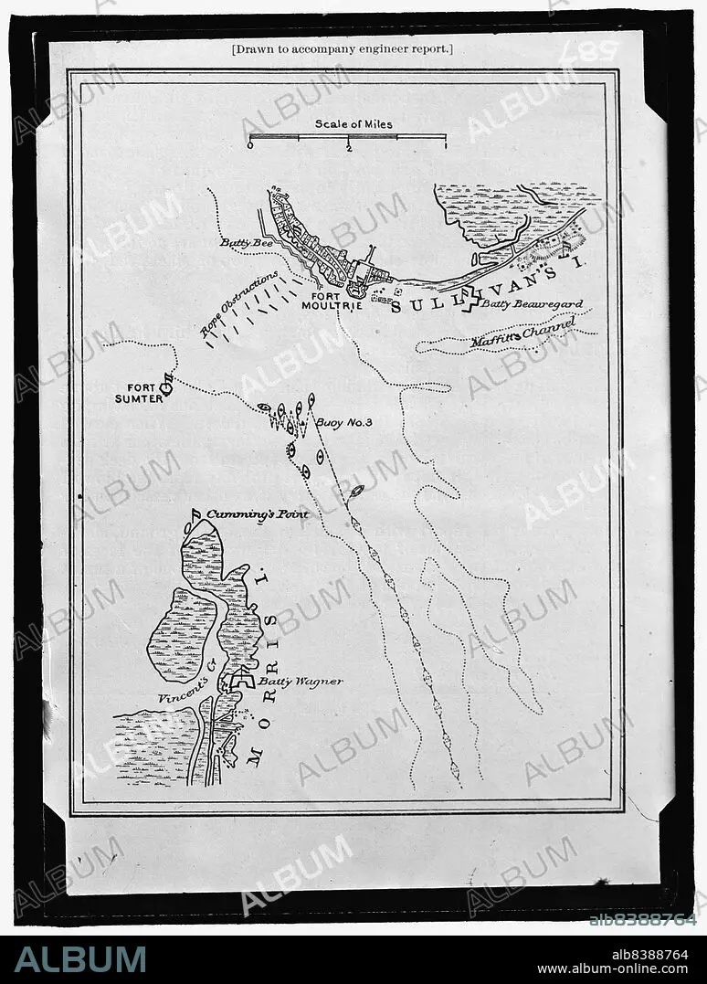
Map showing Fort Sumter and Fort Moultrie, between 1909 and 1914. Creator: Harris & Ewing.
Caption:
Map showing Fort Sumter and Fort Moultrie, between 1909 and 1914. 'Drawn to accompany engineer report'. Battle site, Charleston Harbour, South Carolina: Battery Bee, rope obstructions, Sullivan's Island, Maffitt's Channel, buoys, Cumming's Point, Vincent's Creek, Morris Island, Battery Wagner.
Technique/material:
Photograph
Credit:
Album / Heritage Art/Heritage Images
Releases:
Image size:
7741 x 10235 px | 226.7 MB
Print size:
65.5 x 86.7 cm | 25.8 x 34.1 in (300 dpi)
Keywords:
1900S • 1910S • 1990S • 20TH CENTURY • 90S • AMERICA • AMERICAN CIVIL WAR • AMERICAN REVOLUTION 1775-1783 • AMERICAN REVOLUTIONARY WAR • AMERICAN WAR OF INDEPENDENCE 1775-1783 • AMERICAN • B & W • B / W • B W • B&W • BATTLE OF FORT SULLIVAN • BATTLE OF SULLIVAN'S ISLAND • BATTLE • BLACK & WHITE • BLACK AND WHITE • BUILDING • CENTURY • CHARLESTON HARBOUR • CHARLESTON • COLLECTION • CONCEPT • COUNTRY • EWING • FORT SUMTER • FORT • FORTIFICATION • FORTIFICATIONS • FOTOGRAFIA • GEORGE W. HARRIS • GEORGE W. • GLASS NEGATIVE • GLASS NEGATIVES. GMGPC • HARBOUR • HARRIS & EWING COLLECTION • HARRIS & EWING INC • HARRIS & EWING INC. • HARRIS & EWING PHOTOGRAPHIC STUDIO • HARRIS & EWING • HARRIS & • HARRIS • KUNTZE • LOCATION • MAP • MARTHA EWING NEWCOMBE • MARTHA EWING • MARTHA KUNTZE • MARTHA OF BETHANY • MARTHA • MOMENT IN TIME • NEGATIVE PHOTOGRAPH • NEGATIVE • NEWCOMBE • NINETIES • NINETIES, THE • NINETY DECADE • PHOTO • PHOTOGRAPH • PHOTOGRAPHIE • PHOTOGRAPHY • REBELLION • REVOLUTION • SAINT MARTHA • SOUTH CAROLINA • STILL IMAGE • UNITED STATES OF AMERICA • UNITED STATES • USA • WAR
