alb3907897
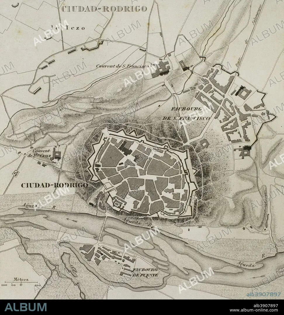
Napoleonic map. Ciudad Rodrigo (province of Salamanca, Castile and Leon, Spain). During the Peninsulan War the city was besieged twice, 1810 and 1812. Atlas de l'Histoire du Consulat et de l'Empire. History of the Consulate and the Empire of France under Napoleon by Marie Joseph Louis Adolphe Thiers (1797-1877). Drawings by Dufour, engravings by Dyonnet. Edited in Paris, 1864.
| Share |
|---|
 Pinterest Pinterest |
 Twitter Twitter |
 Facebook Facebook |
 Copy link Copy link |
 Email Email |
|
Add to another lightbox |
|
Add to another lightbox |


Buy this image.
Select the use:

Caption: Napoleonic map. Ciudad Rodrigo (province of Salamanca, Castile and Leon, Spain). During the Peninsulan War the city was besieged twice, 1810 and 1812. Atlas de l'Histoire du Consulat et de l'Empire. History of the Consulate and the Empire of France under Napoleon by Marie Joseph Louis Adolphe Thiers (1797-1877). Drawings by Dufour, engravings by Dyonnet. Edited in Paris, 1864.
Personalities: NAPOLÉON (1769-1821)
Credit: Album / Prisma
Releases: ? Model Release: No - ? Property Release: No
Rights questions?
Rights questions?
Image size: 3543 × 3733 px | 37.8 MB
Print size: 30.0 × 31.6 cm | 1394.9 × 1469.7 in (300 dpi)
Keywords: 1810 • 1864 • 19 CENTURY • 19TH CENTURY • 19TH CENTURY. • 19TH • 19TH-CENTURY • ADOLPHE THIERS • AGUEDA RIVER • AGUEDA • ANCIENT • ANTIQUE • ATLANTE • ATLANTEAN • ATLAS DE L'HISTOIRE DU CONSULAT ET DE L'EMPIRE • ATLAS DE L'HISTORIE DU CONSULAT ET DE L'EMPIRE • ATLAS • AUTHOR • CARTOGRAPHY • CASTELLANO • CASTILE AND LEON • CASTILIAN • CASTILLA-LEON • CITY • CIUDAD RODRIGO • CONQUERING • CONQUEST • DESIGNING • DRAWING • DRAWN • DUFOUR • DYONNET • EDITION • EMPIRE • ENGRAVED • ENGRAVER • ENGRAVING (ARTWORK) • ENGRAVING • ENGRAVING. • ENGRAVINGS • ETCHING • EUROPA • EUROPE • EUROPEA • EUROPEAN • EUROPEANS • FIRST FRENCH EMPIRE • FORTIFIED TOWN • FORTIFIED • FRANCE • FRANCE. • FRANÇAIS • FRENCH EMPIRE • FRENCH • GEOGRAFIA • GEOGRAPHICAL • GEOGRAPHY • HISTORIA UNIVERSAL • HISTORIA • HISTORIC • HISTORICAL • HISTORY OF THE CONSULATE AND THE EMPIRE OF FRANCE UNDER NAPOLEON • HISTORY OF THE CONSULATE AND THE NAPOLEON EMPIRE • HISTORY • HISTORY. • ILLUSTRATION • ILLUSTRATIONS • ILUSTRATION • LA FRANCE • LOCATION • MAP MAKING • MAP • MAP-MAKING • MAPS • MARIE JOSEPH LOUIS ADOLPHE THIERS • MODERN AGE • MODERN ERA • MODERN PERIOD • NAPOLEON I BONAPARTE • NAPOLEON I • NAPOLEON'S FRENCH EMPIRE • NAPOLEON • NAPOLEONIC EMPIRE • NAPOLEONIC ERA • NAPOLEONIC INVASION • NAPOLEONIC MAP • NAPOLEONIC PERIOD • NAPOLEONIC WAR • NAPOLEONIC WARS • NINETEENTH CENTURY • OLD • PEACE, NAPOLEONIC WARS • PENINSULAR WAR • PLAN (CARTOGRAPHY) • PLAN • PLANE • PRINT • PROVINCE OF SALAMANCA • PUBLICATION • QUEEN VICTORIA I • QUEEN VICTORIA • SIEGE 1810 • SIEGE 1812 • SIEGE • SIEGED • SITE • SPAIN • SPANISH WAR FOR INDEPENDENCE • SPANISH • SURFACE • TERRITORY • THIERS • TRIUMPH • URBANISM • URBE • VICTORIA I • VICTORIA • VICTORY • VILLAGE • WALLED • WAR OF INDEPENDENCE • WAR OF SPANISH INDEPENDENCE • XIX CENTURY
