alb3825657
NEW ZEALAND
| Share |
|---|
 Pinterest Pinterest |
 Twitter Twitter |
 Facebook Facebook |
 Copy link Copy link |
 Email Email |
|
Add to another lightbox |
|
Add to another lightbox |


Title:
NEW ZEALAND
Caption:
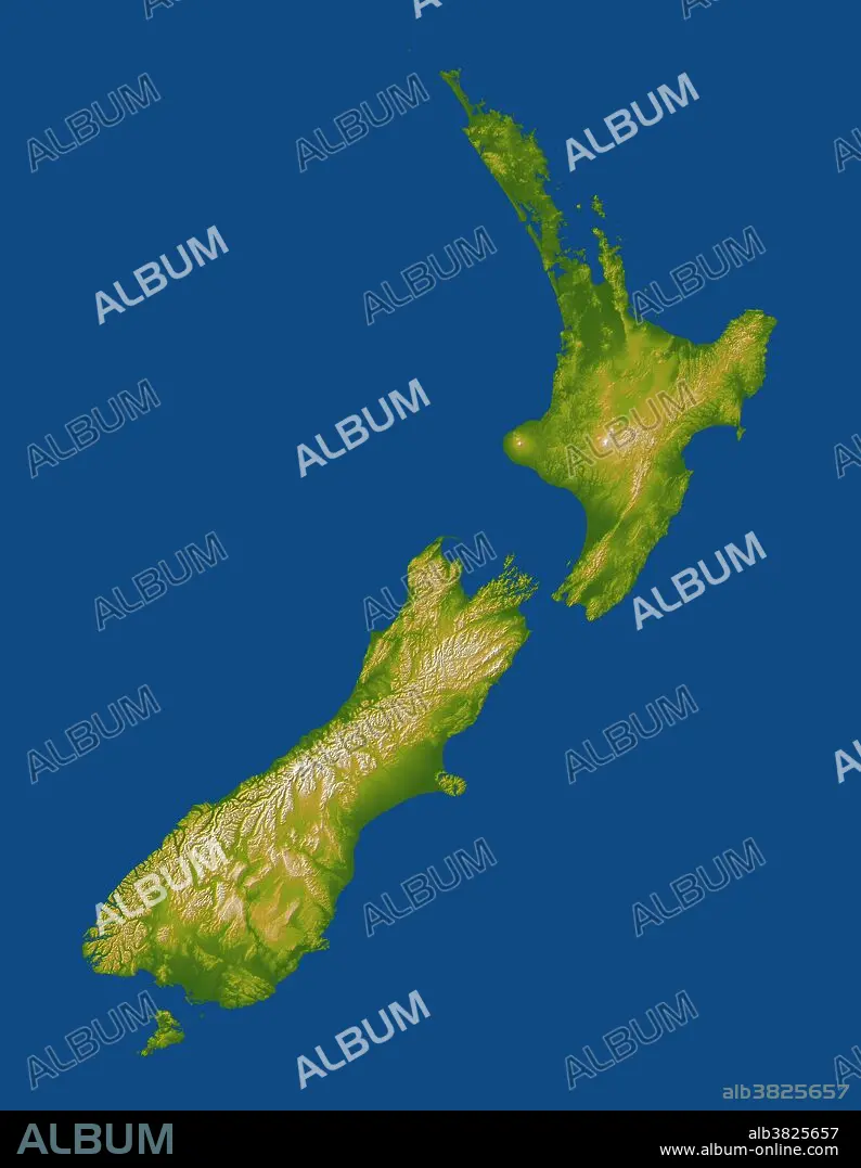
New Zealand straddles the juncture of the Indo-Australian and Pacific tectonic plates, two of Earth's major crustal plates. The North Island lies at the southern end of the west-over-east plate convergence. The Pacific plate dives under the North Island and this subduction process leads to melting of rocks at depth, the rise of magma to the surface, and the formation of volcanoes and other geothermal features. Most notable are Mount Taranaki on the west coast, and Mounts Ruapehu, Ngauruhoe, and Tongariro just south of the island's centerpoint, all of which are shown with white peaks in this display. The South Island straddles the cross point of the subduction scissor pattern and prominently features a fault system that connects the two subduction zones. The east-over-west plate convergence generally occurs south of the South Island. The Alpine fault is the major strand of this fault system along most of the length of the island, near and generally paralleling the west coast. Its impact upon the topography is unmistakable, forming an extremely sharp and straight northwest boundary to New Zealand's tallest mountains, the Southern Alps. Elevation data used in this image were acquired by the Shuttle Radar Topography Mission aboard the Space Shuttle Endeavour, launched on Feb. 11, 2000.
Credit:
Album / Science Source / NASA/JPL/NGA
Releases:
Model: No - Property: No
Rights questions?
Rights questions?
Image size:
4500 x 5800 px | 74.7 MB
Print size:
38.1 x 49.1 cm | 15.0 x 19.3 in (300 dpi)
Keywords:
AERIAL PHOTOGRAPHY • AERIAL • ALPINE FAULT • ALPS • ENDEAVOR IMAGE • FAULT • GEOGRAPHY • GEOLOGIA • GEOLOGICAL FORMATION • GEOLOGY • INDO-AUSTRALIAN PLATE • INDOAUSTRIAN PLATE • ISLAND • MOUNT NGAURUHOE • MOUNT RUAPEHU • MOUNT TARANAKI • MOUNT TONGARIRO • MOUNTAIN • MT. NGAURUHOE • MT. RUAPEHU • MT. TARANAKI • MT. TONGARIRO • NEW ZEALAND • OCEAN, PACIFIC • PACIFIC OCEAN • PACIFIC PLATE • ROTORUA GEOTHERMAL FIELD • SATELLITE IMAGE • SATELLITE PHOTOGRAPHY • SHUTTLE RADAR TOPOGRAPHY MISSION • SOUTHERN ALPS • SPACE SHUTTLE IMAGE • SRTM IMAGE • TECTONICS • TOPOGRAPHY • VOLCANIC • VOLCANO • VOLCANOLOGY • VULCAN • VULCANO
