alb3909128
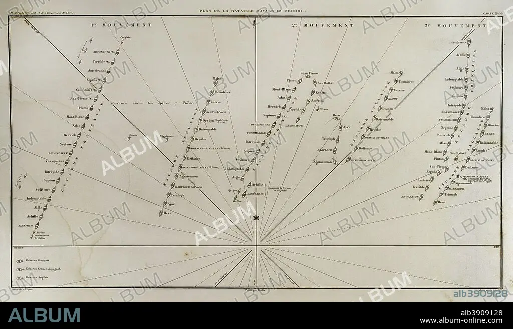
Plane of Ferrol Expedition (Battle of Brion). It takes place on the Sunday closest to August 25th in the Brion's Mounts, in 1800. It was a part of the War of the Second Coalition. There fought the troops stationed in Ferrol and invading English troops who landed on the beach of Don_inos, in the context of the Anglo-Spanish War of 1796-1808 initiated by Spain as an ally of France against England. Atlas de l'Histoire du Consulat et de l'Empire. History of the Consulate and the Empire of France under Napoleon by Marie Joseph Louis Adolphe Thiers (1797-1877). Drawings by Dufour and engravings by Dyonnet. Edited in Paris, 1864.
| Share |
|---|
 Pinterest Pinterest |
 Twitter Twitter |
 Facebook Facebook |
 Copy link Copy link |
 Email Email |
|
Add to another lightbox |
|
Add to another lightbox |


Buy this image.
Select the use:

Caption: Plane of Ferrol Expedition (Battle of Brion). It takes place on the Sunday closest to August 25th in the Brion's Mounts, in 1800. It was a part of the War of the Second Coalition. There fought the troops stationed in Ferrol and invading English troops who landed on the beach of Don_inos, in the context of the Anglo-Spanish War of 1796-1808 initiated by Spain as an ally of France against England. Atlas de l'Histoire du Consulat et de l'Empire. History of the Consulate and the Empire of France under Napoleon by Marie Joseph Louis Adolphe Thiers (1797-1877). Drawings by Dufour and engravings by Dyonnet. Edited in Paris, 1864.
Credit: Album / Prisma
Releases: ? Model Release: No - ? Property Release: No
Rights questions?
Rights questions?
Image size: 4961 × 2926 px | 41.5 MB
Print size: 42.0 × 24.8 cm | 1953.1 × 1152.0 in (300 dpi)
Keywords: 1796 • 1800'S • 1800 • 1864 • 19 CENTURY • 19TH CENTURY • 19TH CENTURY. • 19TH • 19TH-CENTURY • 25 • 26 • ADOLPHE THIERS • ANCIENT • ANGLO-SPANISH WAR • ANTIQUE • ARMADA • ATLAS DE L'HISTOIRE DU CONSULAT ET DE L'EMPIRE • ATLAS DE L'HISTORIE DU CONSULAT ET DE L'EMPIRE • AUGUST • BARGE • BARK • BARQUE • BATTLE OF BRION • BATTLE • BATTLE, NAVAL • BOAT • BOATS • BRITAIN • BRITISH • BUQUE • CARTOGRAPHY • COMBAT • CONFRONTATION • CONSULATE, THE • CRAFT • DESIGNING • DISPUTE • DRAWING • DRAWN • DUFOUR • DYONNET • EMBARKATION • EMPIRE • ENGLAND'S • ENGLAND • ENGLISH • ENGRAVED • ENGRAVING (ARTWORK) • ENGRAVING • ENGRAVING. • ENGRAVINGS • ETCHING • EUROPA • EUROPE • EUROPEA • EUROPEAN • EUROPEANS • FERROL EXPEDITION • FERROL • FIGHT • FIGHTING • FIRST FRENCH EMPIRE • FLEET • FRANCE • FRANCE. • FRANÇAIS • FRENCH ARMY • FRENCH EMPIRE • FRENCH • FRIGATE • GALICE • GALICIA • GEOGRAFIA • GEOGRAPHICAL • GEOGRAPHY • GREAT BRITAIN • GREAT-BRITAIN • GUERRA • HISTORIA UNIVERSAL • HISTORIA • HISTORIC • HISTORICAL • HISTORY OF THE CONSULATE AND THE EMPIRE OF FRANCE UNDER NAPOLEON • HISTORY OF THE CONSULATE AND THE NAPOLEON EMPIRE • HISTORY • HISTORY. • HUNDRED YEARS WAR • ILLUSTRATION • ILLUSTRATIONS • ILUSTRATION • INGLES • LA FRANCE • MAP MAKING • MAP • MAP-MAKING • MAPS • MARIE JOSEPH LOUIS ADOLPHE THIERS • MARÍTIMA • MARITIME NAVIGATION • MARITIME • MILITAR • MILITARS • MILITARY • MODERN AGE • MODERN ERA • MODERN PERIOD • MOVEMENT • MOVEMENTS • NAPOLEON'S FRENCH EMPIRE • NAPOLEONIC EMPIRE • NAPOLEONIC ERA • NAPOLEONIC MAP • NAPOLEONIC PERIOD • NAVAL BATTLE • NAVAL WAR • NAVAL • NAVE • NAVEGATION • NAVIGATION • NAVIO • NAVY • NINETEENTH CENTURY • OLD • PLAN (CARTOGRAPHY) • PRINT • ROYAL NAVY • SAILING • SCUFFLE • SEA • SEASCAPE • SHIP • SHIP: EMBARKATION • SHIPPING • SHIPS • SPAIN • SPANISH VICTORY • SPANISH • SQUAD • SQUADRON • SQUADS • STRATEGY • STRUGGLE • THIERS • U. K. • UNITED KINGDOM • VESSEL • WAR AT SEA • WAR OF THE SECOND COALITION • WAR • WARFARE • WARS • XIX CENTURY
