alb3907891
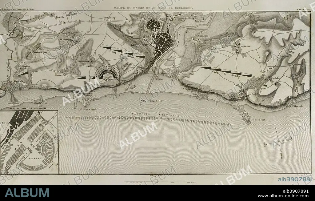
Map of Boulogne-sur-Mer. In French coast on the English Channel. it was a staging area for Napoleon's troops for several months in 1805, during his planned invasion of the United Kingdom. Atlas de l'Histoire du Consulat et de l'Empire. History of the Consulate and the Empire of France under Napoleon by Marie Joseph Louis Adolphe Thiers (1797-1877). Drawings by Dufour, engravings by Dyonnet. Edited in Paris, 1864.
| Share |
|---|
 Pinterest Pinterest |
 Twitter Twitter |
 Facebook Facebook |
 Copy link Copy link |
 Email Email |
|
Add to another lightbox |
|
Add to another lightbox |


Buy this image.
Select the use:

Caption:
Map of Boulogne-sur-Mer. In French coast on the English Channel. it was a staging area for Napoleon's troops for several months in 1805, during his planned invasion of the United Kingdom. Atlas de l'Histoire du Consulat et de l'Empire. History of the Consulate and the Empire of France under Napoleon by Marie Joseph Louis Adolphe Thiers (1797-1877). Drawings by Dufour, engravings by Dyonnet. Edited in Paris, 1864.
Personalities:
Credit:
Album / Prisma
Releases:
Image size:
5079 x 2977 px | 43.3 MB
Print size:
43.0 x 25.2 cm | 16.9 x 9.9 in (300 dpi)
Keywords:
1804 • 1805 • 1864 • 19 CENTURY • 19TH CENTURY • 19TH CENTURY. • 19TH • 19TH-CENTURY • ADOLPHE THIERS • ANCIENT • ANTIQUE • ARMADA • ARMIES ARMY • ARMIES • ARMY'S • ARMY • ATLANTE • ATLANTEAN • ATLAS DE L'HISTOIRE DU CONSULAT ET DE L'EMPIRE • ATLAS DE L'HISTORIE DU CONSULAT ET DE L'EMPIRE • ATLAS • AUTHOR • BASIN • BOULOGNE • BOULOGNE-SUR-MER • BREAKWATER • BRITAIN • CARTOGRAPHY • CITY • COAST • COASTAL • COASTLINE • DESIGNING • DOCK • DRAWING • DRAWN • DUFOUR • DYONNET • EDITION • EMPIRE • ENGLAND'S • ENGLAND • ENGLISH CHANNEL • ENGRAVED • ENGRAVER • ENGRAVING (ARTWORK) • ENGRAVING • ENGRAVING. • ENGRAVINGS • ETCHING • EUROPA • EUROPE • EUROPEA • EUROPEAN • EUROPEANS • FIRST FRENCH EMPIRE • FLEET • FLOTILLA • FRANCE • FRANCE. • FRANCIA • FRANKREICH • FRANÇAIS • FRENCH EMPIRE • FRENCH • GEOGRAFIA • GEOGRAPHICAL • GEOGRAPHY • GRANDE ARMEE • GREAT BRITAIN • GREAT-BRITAIN • GUERRA • HARBOR • HARBOUR • HISTORIA UNIVERSAL • HISTORIA • HISTORIC • HISTORICAL • HISTORY OF THE CONSULATE AND THE EMPIRE OF FRANCE UNDER NAPOLEON • HISTORY OF THE CONSULATE AND THE NAPOLEON EMPIRE • HISTORY • HISTORY. • HUNDRED YEARS WAR • ILLUSTRATION • ILLUSTRATIONS • ILUSTRATION • INCURSION • INVADE • INVADER • INVASION • JETTY • LA FRANCE • LA GRANDE ARMÉE • LA MANCHE • MAP MAKING • MAP • MAP-MAKING • MAPS • MARIE JOSEPH LOUIS ADOLPHE THIERS • MARINE • MARITIME • MODERN AGE • MODERN ERA • MODERN PERIOD • MOORING • NAPOLEON I BONAPARTE • NAPOLEON I • NAPOLEON'S FRENCH EMPIRE • NAPOLEON'S TROOP • NAPOLEON • NAPOLEONIC EMPIRE • NAPOLEONIC MAP • NAPOLEONIC PERIOD • NAPOLEONIC WAR • NAPOLEONIC WARS • NAPOLONIC WARS • NAVY • NINETEENTH CENTURY • NORTHERN FRANCE • OLD • PARIS • PAS DE CALAIS • PEACE, NAPOLEONIC WARS • PIER • PLAN (CARTOGRAPHY) • PLAN • PLANE • PLANNED INVASION OF UNITED KINGDOM • PORT • PRÉPARATION • PREPARATIONS • PREPARING • PRINT • SEA • SEASCAPE • SEASHORE • SEASIDE • SHORELINE • STRATEGIC PLACE • STRATEGY • TERRITORY • THIERS • U. K. • UNITED KINGDOM • URBE • VILLAGE • WAR • WARFARE • WARS • WHARF • XIX CENTURY
