alb2203293
World Map 1599
| Share |
|---|
 Pinterest Pinterest |
 Twitter Twitter |
 Facebook Facebook |
 Copy link Copy link |
 Email Email |
|
Add to another lightbox |
|
Add to another lightbox |


Title:
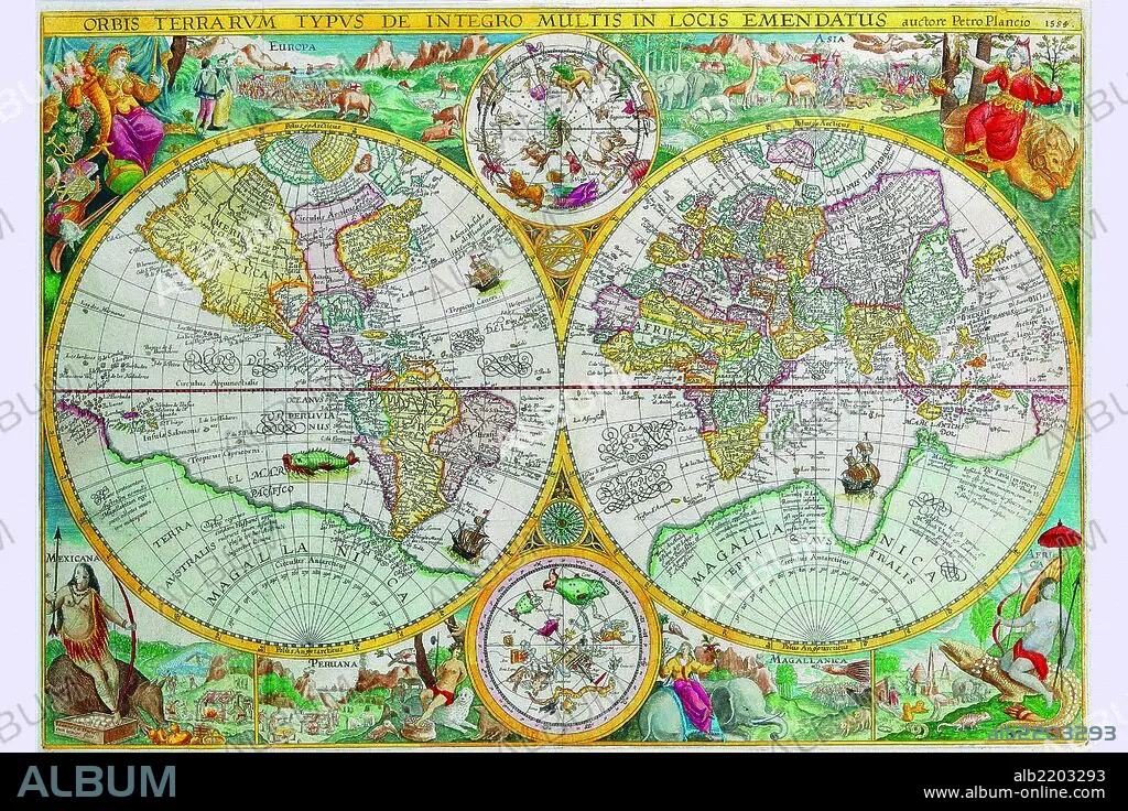
World Map 1599
Caption:
Petrus Plancius (1552 – May 15, 1622) was a Dutch astronomer, cartographer and clergyman. He was born as Pieter Platevoet in Dranouter, now in Heuvelland, West Flanders. He studied theology in Germany and England. At the age of 24 he became a minister in the Dutch Reformed Church. He was one of the founders of the Dutch East India Company for which he drew over 100 maps. In 1592 he published his best known world map titled "Nova et exacta Terrarum Tabula geographica et hydrographica". Apart from maps he published journals and navigational guides and developed a new method for determining longitude. He also introduced the Mercator projection for navigational maps. Plancius was closely acquainted with Henry Hudson, an explorer of the New World.
Credit:
Album / Universal Images Group / Universal History Archive/UIG
Releases:
Model: No - Property: No
Rights questions?
Rights questions?
Image size:
3912 x 2608 px | 29.2 MB
Print size:
33.1 x 22.1 cm | 13.0 x 8.7 in (300 dpi)
Keywords:
1599 • AFRICA • AFRICAN • AMSTERDAM • ANTHROPOMORPHIC • ANTIQUE • ATLAS • AUGUSTUS • CAESAR • CALIGULA • CARTOGRAPHERS • CARTOGRAPHIC • CARTOGRAPHY • CESAR • CLAUDIUS • DUTCH • EMPERADOR OF ROME • EMPERORS, ROMAN • GALÉA • GEOGRAPHIC • GEOGRAPHY • HAVANA • HYDROGRAPHIC • JERUSALEM • MAGELLANICA • MAP MAKING • MAP • MAPMAKERS • MAPS • NERO • NETHERLANDISH • ORBIS • OTHO VESPASIAN • PERNAMBUCO • PICTORIAL • PLAN (CARTOGRAPHY) • ROMAN EMPEROR • ROME • SECOND-HAND BOOKSHOP • TUNEZ • TUNIS • TUNISIA • USED BOOK STORE • WORLD
