alb3812619
Tower of Babel, 17th Century
| Share |
|---|
 Pinterest Pinterest |
 Twitter Twitter |
 Facebook Facebook |
 Copy link Copy link |
 Email Email |
|
Add to another lightbox |
|
Add to another lightbox |


Buy this image.
Select the use:

Title:
Tower of Babel, 17th Century
Caption:
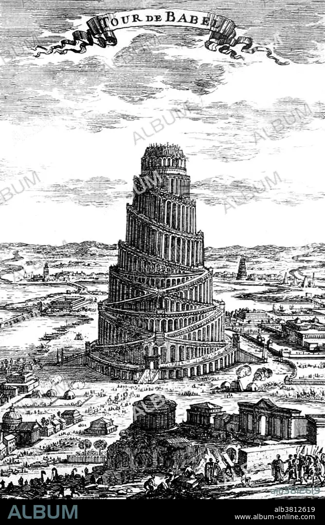
Tower of Babel engraving by Alain Manesson Mallet (1630-1706) a French cartographer and engineer. His Description de L'Universe contains a wide variety of information, including star maps, maps of the ancient and modern world, and a synopsis of the customs, religion and government of the many nations included in his text. According to Genesis the people of the Earth built a tower to scale heaven. God intervened and punished them for their presumption by destroying the tower and scattering the population. He confused their speech so that they no longer understood each other thus causing the world's multiplicity of languages. Shinar occurs eight times in the Hebrew Bible, in which it refers to Babylonia. Digging in the plains of Shinar, a biblical geographical locale of uncertain boundaries in Mesopotamia, archaeologists discovered the remains of certain great towers that early Babylonians had built. Some archaeologists have felt that they may even have found the foundation of this original tower of Babel. That is very hard to determine. But they did find that the Babylonians built great towers called ziggurats, which were built in a circular fashion with an ascending staircase that terminates in a shrine at the top, around which are written the signs of the zodiac.
Personalities:
Credit:
Album / Science Source / New York Public Library
Releases:
Model: No - Property: No
Rights questions?
Rights questions?
Image size:
2700 x 4140 px | 32.0 MB
Print size:
22.9 x 35.1 cm | 9.0 x 13.8 in (300 dpi)
Keywords:
ALAIN MALLET • ALAIN MANESSON MALLET • ANCIENT CIVILIZATION • ANCIENT CULTURE • ANCIENT • ARCHITECTURAL • ARCHITECTURE • ART • ARTWORK • BABEL • BABEL: TOWER OF • BABYLON • BABYLONIA • BIBLE • BIBLICAL • BUILDER • BUILDING • BW • CELEBRITIES • CELEBRITY • CHRISTIAN • CONSTRUCTION • CREW • DESIGN • DRAWING • ENGINEERING • ENGRAVING • EVENT • EVENTS • FAMOUS PEOPLE • FAMOUS • GENESIS • HEBREW • HISTORIC • HISTORICAL • HISTORY • ILLUSTRATION • ILLUSTRATIONS • IMPORTANT • JEWISH • JEWISH-CHRISTIAN • JUDEO-CHRISTIAN • LABORERS • LEGEND • LEGENDARY • MALLET • MESOPOTAMIA • MESOPOTAMIAN • MYTH • MYTHIC • MYTHOLOGICAL • MYTHOLOGY • NOTABLE • OLD TESTAMENT • RELIGION • RELIGIOUS • SOCIAL ANTHROPOLOGY • TECHNOLOGY • TOWER OF BABEL • TOWER • WELL-KNOWN • WORKERS
