alb1748441
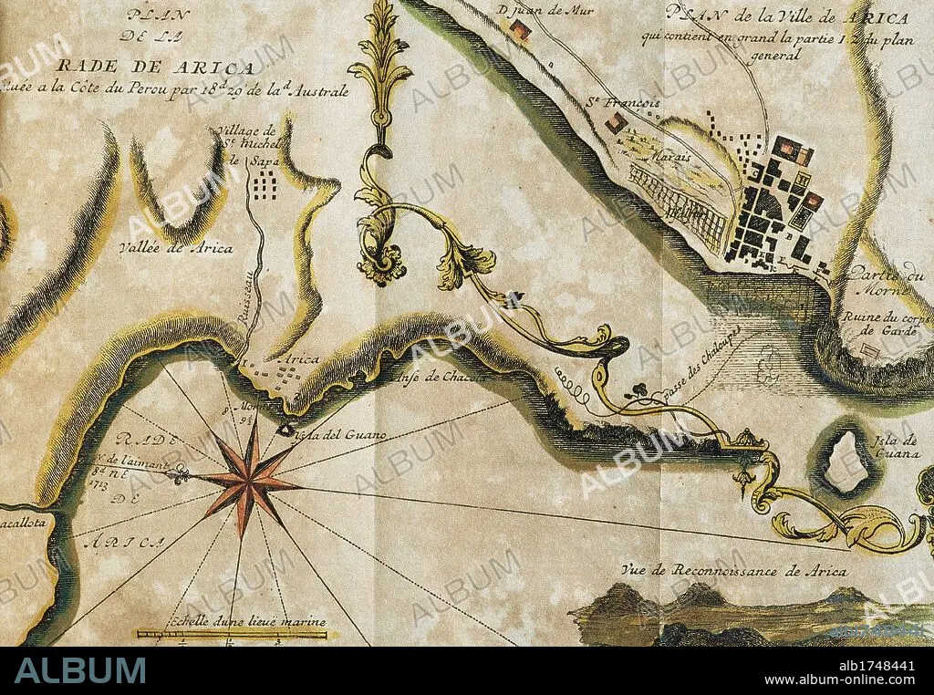
AMERICA DEL SUR. PERU. SIGLO XVIII. PLANO DE LA RADA DE ARICA. Situado en la costa del Perú, a 18,29 grados de latitud Austral y Plano de la villa de Arica, vista general, con el poblado de San Miguel de Sapa, Rada de Arica, Valle de Arica y otros detalles situados en un plano o mapa del año 1879 que pasó a pertenecer a Chile. Grabado francés del año 1716. Biblioteca de Cataluña. Barcelona.
| Share |
|---|
 Pinterest Pinterest |
 Twitter Twitter |
 Facebook Facebook |
 Copy link Copy link |
 Email Email |
|
Add to another lightbox |
|
Add to another lightbox |


Buy this image.
Select the use:

Caption:
Automatic translation: SOUTH AMERICA. PERU. CENTURY XVIII. PLAN OF THE RADA OF ARICA. Located on the coast of Peru, at 18.29 degrees Austral latitude and Plan of the town of Arica, general view, with the town of San Miguel de Sapa, Rada de Arica, Valle de Arica and other details located on a plane or map of the year 1879 that happened to belong to Chile. French engraving of the year 1716. Library of Catalonia. Barcelona
AMERICA DEL SUR. PERU. SIGLO XVIII. PLANO DE LA RADA DE ARICA. Situado en la costa del Perú, a 18,29 grados de latitud Austral y Plano de la villa de Arica, vista general, con el poblado de San Miguel de Sapa, Rada de Arica, Valle de Arica y otros detalles situados en un plano o mapa del año 1879 que pasó a pertenecer a Chile. Grabado francés del año 1716. Biblioteca de Cataluña. Barcelona.
Credit:
Album / Kurwenal / Prisma
Releases:
Image size:
4961 x 3437 px | 48.8 MB
Print size:
42.0 x 29.1 cm | 16.5 x 11.5 in (300 dpi)
Keywords:
18TH CENTURY • 18TH CENTURY, THE • 18TH CENTURY. • 18TH • ANCIENT CARTOGRAPHY • ARICA • CARTOGRAPHY • CHILE • COMPASS ROSE • COMPASS • HISTORIA UNIVERSAL • HISTORIA • HISTORY OF ECONOMY • HISTORY • HISTORY. • LATIN AMERICA • LATIN AMERICAN • LATINOAMERICA • MAP MAKING • MAP • MAPS • PERU • PERUVIAN • PLAN (CARTOGRAPHY) • PLAN • PLANE • ROAD (SHIP) • SOUTH AMERICA • SUDAMERICA • URBANISM • WINDROSE • XVIII CENTURY
