alb5595318
ANONYMOUS. Map of the Battle near Roßbach / 1757
| Share |
|---|
 Pinterest Pinterest |
 Twitter Twitter |
 Facebook Facebook |
 Copy link Copy link |
 Email Email |
|
Add to another lightbox |
|
Add to another lightbox |


Buy this image.
Select the use:

Author:
Title:
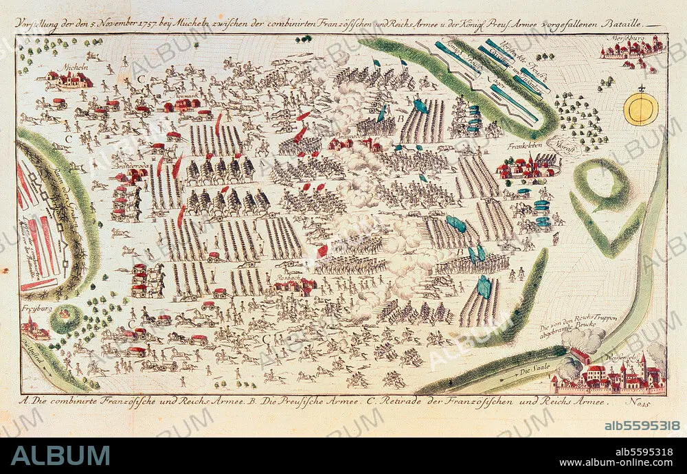
Map of the Battle near Roßbach / 1757
Caption:
Seven Year War 1756-63 / Battle near Rossbach 5 Nov. 1757 (Frederick the Great defeats the French led by Soubise and the Imperial Army). Map of the battle. Copper engraving, coloured. 40 × 24cm. Merseburg, Zentrales Staatsarchiv.
Technique/material:
GRAPHIC ART • PRINT (ART) • COPPER ENGRAVING
Museum:
Merseburg, Zentrales Staatsarchiv
Credit:
Album / akg-images
Releases:
Model: No - Property: No
Rights questions?
Rights questions?
Image size:
4059 x 2585 px | 30.0 MB
Print size:
34.4 x 21.9 cm | 13.5 x 8.6 in (300 dpi)
Keywords:
18TH CENTURY • 18TH CENTURY, THE • 18TH CENTURY. • 18TH • 2ND MILLENNIUM A. D. • ANONYMOUS • AUSTRIA • BATTLE PLAN • BATTLE • CAMPAIGN PLAN • COMBAT • COPPER ENGRAVING • DISPUTE • FIGHT • FIGHTING • FRANCE • FREDERICK II THE GREAT • GERMANY • GRAPHIC ART • GRAPHIC ARTS • GUERRA • HISTORIA UNIVERSAL • HISTORIA • HISTORICAL EVENT • HISTORY • HISTORY. • HUNDRED YEARS WAR • MAP • MAPS • MERSEBURG • MERSEBURG, ZENTRALES STAATSARCHIV • MILITAR • MILITARS • MILITARY • PLAN (CARTOGRAPHY) • PRINT (ART) • PRINTED GRAPHICS • PRUSSIA (STATE) • ROSSBACH • SCUFFLE • SEVEN YEARS WAR • SEVEN YEARS' WAR • SILESIAN WAR • STRATEGY • STRUGGLE • WAR • WAR, SEVEN YEARS • WAR, SILESIAN • WARFARE • WARS • XVIII CENTURY
