alb3833961
Aceh, Indonesia, Before and After 2004 Tsunami
| Share |
|---|
 Pinterest Pinterest |
 Twitter Twitter |
 Facebook Facebook |
 Copy link Copy link |
 Email Email |
|
Add to another lightbox |
|
Add to another lightbox |


Buy this image.
Select the use:

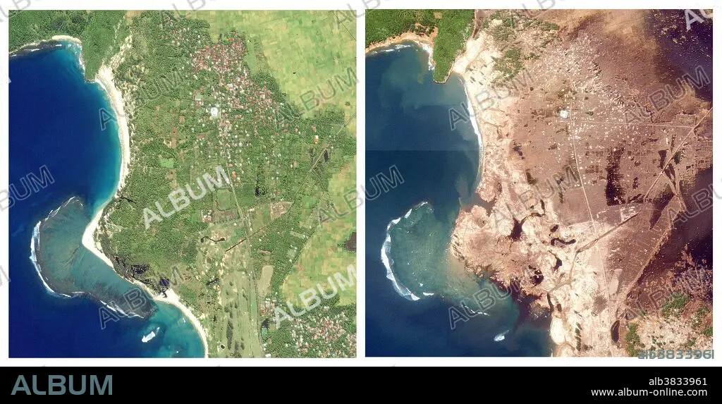
Title: Aceh, Indonesia, Before and After 2004 Tsunami
Caption: Aceh, Indonesia, before and after the southeast Asian earthquake and tsunami of December 26, 2004. The image on the left is from January 10, 2003; the image on the right, showing massive devastation, is from December 29, 2004. The Indonesian province of Aceh was hit hardest by the earthquake and tsunamis. Aceh is located on the northern tip of the island of Sumatra. Early Western media attention was focused on Sri Lanka and Thailand, even though the earthquake epicenter was closer to Aceh, and the largest waves struck the northwestern coast of Sumatra. On Decemebr 29, estimates of the death toll in Indonesia were over 80,000, more than half the global total. The town of Lhoknga, on the west coast of Sumatra near the capital of Aceh, Banda Aceh, was completely destroyed by the tsunami, with the exception of the mosque in the city's center. These high-resolution satellite images show Lhoknga before (left) and after (right). Almost all the trees, vegetation, and buildings in the area were washed away. Behind the town, low-lying agricultural areas remained covered with water 4 days after the disaster, and sand on the nearby beaches was completely removed. The wave height might have exceeded 15 meters (50 feet) when it struck the shore. Equivalent devastation extends 225 km southeast along the Sumatran Coast, in a band up to 3 km (1.9 miles) deep.
Personalities: INDONESIAN
Category: WEATHER • Ecology & Environment
Credit: Album / Science Source / Jessica Wilson/NASA
Releases: ? Model Release: No - ? Property Release: No
Rights questions?
Rights questions?
Image size: 6600 × 3350 px | 63.3 MB
Print size: 55.9 × 28.4 cm | 2598.4 × 1318.9 in (300 dpi)
Keywords: 2003 • 2004 • ACEH • AERIAL • AFTER • ASIA • BAD STORM • BANDA ACEH • BEFORE • COAST • COASTAL • DAMAGE • DECEMBER 26 • DECEMBER 29 • DESTRUCTION • DEVASTATION • EARTHQUAKE • ECOLOGY & ENVIRONMENT • EPICENTER • FLOOD • FLOODWATER • HURTING • INDONESIA • INDONESIAN • INUNDATION • LHOKNGA • METEOROLOGICAL_DISASTER • NATURAL DISASTER • SATELLITE IMAGE • SATELLITE MAP • SEVERE STORM • SOUTH-EAST ASIAN • SOUTHEAST ASIA • STORM • STORMS • SUMATRA • TEMPEST • TEMPORAL • TEMPORARY • THUNDERSTORM • TSUNAMI • WEA • WEATHER • WEATHER: STORM • WEATHER: THUNDERSTORM • WEATHER: WEA
