alb3124106
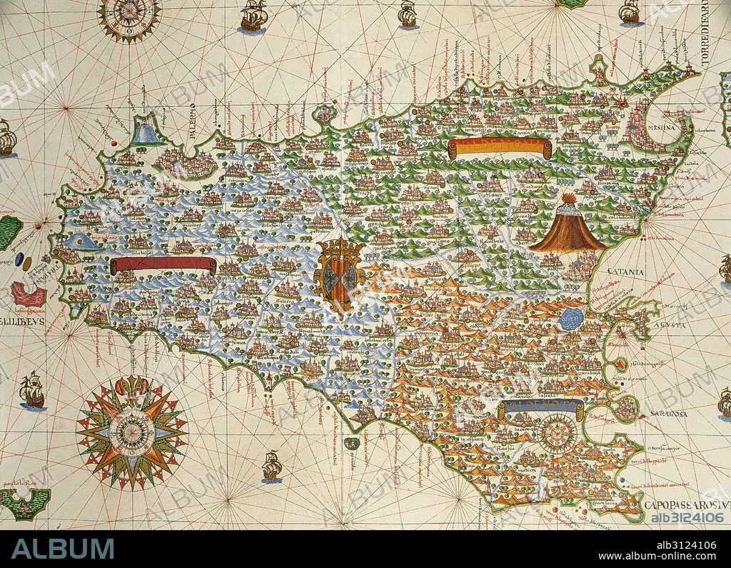
Island of Sicily. Portolan chart by Joan Martines, Spanish cartographer of the Majorcan cartographic school (16th century). Manuscript of 19 double-folio maps. Messina, Sicily, 1587. National Library, Madrid, Spain.
| Share |
|---|
 Pinterest Pinterest |
 Twitter Twitter |
 Facebook Facebook |
 Copy link Copy link |
 Email Email |
|
Add to another lightbox |
|
Add to another lightbox |


Buy this image.
Select the use:

Caption: Island of Sicily. Portolan chart by Joan Martines, Spanish cartographer of the Majorcan cartographic school (16th century). Manuscript of 19 double-folio maps. Messina, Sicily, 1587. National Library, Madrid, Spain.
Credit: Album / Prisma
Releases: ? Model Release: No - ? Property Release: No
Rights questions?
Rights questions?
Image size: 4961 × 3595 px | 51.0 MB
Print size: 42.0 × 30.4 cm | 1953.1 × 1415.4 in (300 dpi)
Keywords: 1587 • 16 16TH XVI XVITH SIXTEENTH CENTURY • 16 CENTURY • 16TH CENTURY • 16TH • AGE OF DISCOVERY • ANCIENT CARTOGRAPHY • ANCIENT MAP • ATLANTE • ATLANTEAN • ATLAS • CARDINAL DIRECTIONS • CARTOGRAPHER • CARTOGRAPHY • COMPASS CARD • COMPASS CHART • COMPASS ROSE • COMPASS • ETNA • EUROPA • EUROPE • FLOWER: ROSE • GEOGRAFIA • GEOGRAPHIC • GEOGRAPHY • HARBOUR-FINDING CHART • HISTORIA UNIVERSAL • HISTORIA • HISTORY • HISTORY. • ISLA • ISLAND • ISLANDS • ITALIA • ITALY • JOAN MARTINES • LETTER • MAJORCAN CARTOGRAPHIC SCHOOL • MAP MAKING • MAP • MAPS • MARITIME NAVIGATION • MARTINES • MEDITERRANEAN SEA • MEDITERRANEAN • MEDITERRANEO • MESINA • MESSINA • MODERN AGE • MODERN ERA • MODERN PERIOD • MOUNT • NAUTICAL CHART • NAUTICAL • NAVEGATION • NAVIGATION • NAVIGATIONAL • OLD MAP • PINK • PLAN (CARTOGRAPHY) • PORTOLAN CHART • PORTOLAN • PORTOLANO • PORTULAN • ROSE (FLOWER) • ROSE OF THE WINDS • ROSE • SAILING • SEA CHART • SEAMANSHIP • SHIPPING • SICILY • SPAIN • SPANISH • TERRITORY • VALDEMONA • VALDENOTO • WIND ROSE • WINDROSE • WINDS • XVI CENTURY
