alb4285560
Map of the Battle of Verdun
| Share |
|---|
 Pinterest Pinterest |
 Twitter Twitter |
 Facebook Facebook |
 Copy link Copy link |
 Email Email |
|
Add to another lightbox |
|
Add to another lightbox |


Buy this image.
Select the use:

Title:
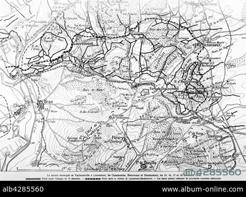
Map of the Battle of Verdun
Caption:
First World War.. Battle of Verdun. Reconquered territory from Vacherauville to Louvemont, les Chambrettes, Bezonvaux and Hardaumont, 15th, 16th, 17th and 18th December 1916.
Credit:
Album / Photo12/Archives Snark
Releases:
Model: No - Property: No
Rights questions?
Rights questions?
Image size:
5049 x 3722 px | 53.8 MB
Print size:
42.7 x 31.5 cm | 16.8 x 12.4 in (300 dpi)
Keywords:
1ST WORLD WAR • 20TH CENTURY • DAMLOUP • FIRST WORLD WAR • FLOWERY • FORT DOUAUMONT • FORT SOUCITY • FORT VAUX • FRANCE • MAP • ORNES • WORLD WAR I (1914-18) • WORLD WAR I • WORLD WAR ONE • WW1 • WWI
