alb3954219
Ptolemy's Map of the World cA. D 150. (1912) Artist: Claudius Ptolemy.
| Share |
|---|
 Pinterest Pinterest |
 Twitter Twitter |
 Facebook Facebook |
 Copy link Copy link |
 Email Email |
|
Add to another lightbox |
|
Add to another lightbox |


Buy this image.
Select the use:

Title: Ptolemy's Map of the World cA. D 150. (1912) Artist: Claudius Ptolemy.
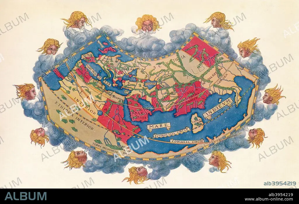
Caption: Ptolemy's Map of the World cA.D 150. The Ptolemy world map is a map of the known world to Hellenistic society in the 2nd century AD. It was based on the description contained in Ptolemy's book Geographia, written c150. Perhaps the most significant contributions of Ptolemy's maps are the first uses of longitudinal and latitudinal lines. Taken from 'A Book of Discovery', published by T. C. & E. C. Jack Ltd. 1912.
Credit: Album / Heritage Images / The Print Collector
Releases: ? Model Release: No - ? Property Release: No
Rights questions?
Rights questions?
Image size: 4664 × 2944 px | 39.3 MB
Print size: 39.5 × 24.9 cm | 1836.2 × 1159.1 in (300 dpi)
Keywords: 1910S • 20TH CENTURY • 2ND CENTURY • BLOWING • BLUE • BLUE. • CARTOGRAPHY • CENTURY • CLAUDIUS OF PTOLEMAEUS • CLAUDIUS PTOLEMY • CLAUDIUS • CLOSE UP • CLOSE-UP • CLOSEUP • COLOR • COLOUR • FLUSH • FOREGROUND • GRECO • GREEK • GREEKS • GUY • HELENICO • HELENISTICO • HELLENIC • HELLENISTIC • JACK • LATITUDE • LONGITUDE • MALE • MAN • MAP MAKING • MAP OF THE WORLD • MAP • MAP-MAKING • MEN • PEOPLE • PTOLEMY • RED • TC AND EC JACK • TC AND EC • WEATHER • WIND • WORLD MAP
