alb4859291
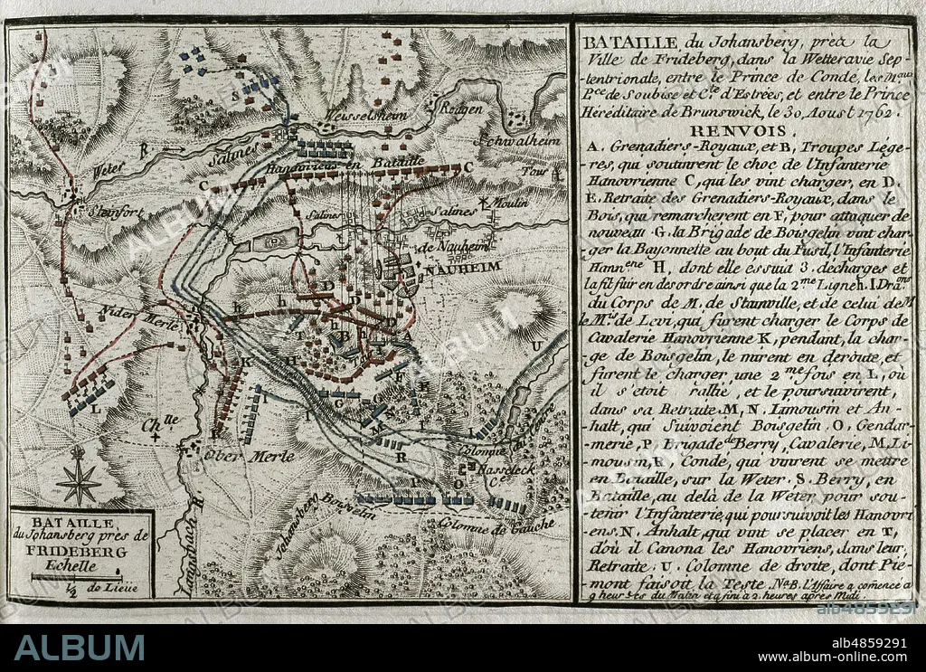
JEAN DE BEAURAIN (1696-1771). FRENCH GEOGRAPHER.. Seven Years War (1756-1763). Map of the Battle of Johannisberg, 1762 (August 30, 1762). French forces led by Louis Joseph, Prince of Conde, defeated Hanoverian and British army under the command of Duke Ferdinand of Brunswick. Published in 1765 by the cartographer Jean de Beaurain (1696-1771) as an illustration of his Great Map of Germany, with the events that took place during the Seven Years War. Allied army in red and the French army in blue. Etching and engraving. French edition, 1765. Military Historical Library of Barcelona (Biblioteca Histórico Militar de Barcelona). Catalonia. Spain.
| Share |
|---|
 Pinterest Pinterest |
 Twitter Twitter |
 Facebook Facebook |
 Copy link Copy link |
 Email Email |
|
Add to another lightbox |
|
Add to another lightbox |


Buy this image.
Select the use:

Caption:
Seven Years War (1756-1763). Map of the Battle of Johannisberg, 1762 (August 30, 1762). French forces led by Louis Joseph, Prince of Conde, defeated Hanoverian and British army under the command of Duke Ferdinand of Brunswick. Published in 1765 by the cartographer Jean de Beaurain (1696-1771) as an illustration of his Great Map of Germany, with the events that took place during the Seven Years War. Allied army in red and the French army in blue. Etching and engraving. French edition, 1765. Military Historical Library of Barcelona (Biblioteca Histórico Militar de Barcelona). Catalonia. Spain.
Location:
Historical Military Library of Barcelona. Catalonia. Spain.
Credit:
Album / Prisma
Releases:
Model: No - Property: No
Rights questions?
Rights questions?
Image size:
4669 x 3148 px | 42.1 MB
Print size:
39.5 x 26.7 cm | 15.6 x 10.5 in (300 dpi)
Keywords:
1762 • 1765 • 18 CENTURY • 18TH CENTURY • 18TH CENTURY, THE • 18TH CENTURY. • 18TH • AUGUST 1762 • BAD NAUHEIM • BATTLE OF JOHANNISBERG • BATTLE • BATTLEFIELD • BATTLEGROUND • BEAURAIN • BRITISH COLONIALISM • BRITISH EMPIRE • BRITISH TROOPS • CARTOGRAPHY • COLONIAL WARS • COLONIALISM • COMBAT • CONFLICT • CONFLICTS • DEUTSCHLAND • DISPUTE • DUKE FERDINAND OF BRUNSWICK • ENGLAND, HISTORY • ENGRAVED • ENGRAVING (ARTWORK) • ENGRAVING • ENGRAVING. • ENGRAVINGS • ETCHING • EUROPA • EUROPE • EUROPEA • EUROPEAN • EUROPEANS • FIGHT • FIGHTING • FRANCE • FRANCE, HISTORY • FRANCE. • FRANÇAIS • FRENCH ARMY • FRENCH COLONIALISM • FRENCH EDITION • FRENCH EMPIRE • FRENCH • GERMANY • GREAT MAP OF GERMANY • GUERRA • HESSE • HESSEN KASSEL • HESSEN-KASSEL • HISTORIA DE FRANCIA • HISTORIA UNIVERSAL • HISTORIA • HISTORICAL MILITARY LIBRARY OF BARCELONA. CATALONIA. SPAIN. • HISTORY ENGLAND • HISTORY FRANCE • HISTORY OF ENGLAND • HISTORY OF FRANCE • HISTORY • HISTORY, ENGLAND • HISTORY, FRANCE • HISTORY. • HUNDRED YEARS WAR • JEAN DE BEAURAIN (1696-1771). FRENCH GEOGRAPHER. • JEAN DE BEAURAIN • JOHANNESBERG • JOHANNISBERG • LA FRANCE • LANDGRAVIATE OF HESSEN-KASSEL • LOUIS JOSEPH • MAP MAKING • MAP • MAPS • MILITARY STRATEGY • MODERN AGE • MODERN ERA • MODERN PERIOD • NAUHEIM • OLD MAP • PLAN (CARTOGRAPHY) • PRINCE OF CONDE • PRINT • SCUFFLE • SEVEN YEARS WAR • SEVEN YEARS' WAR • SILESIAN WAR • STRATEGY • STRUGGLE • WAR IN THE COLONIES • WAR • WAR, SEVEN YEARS • WAR, SILESIAN • WARFARE • WARS • XVIII CENTURY
