alb3909136
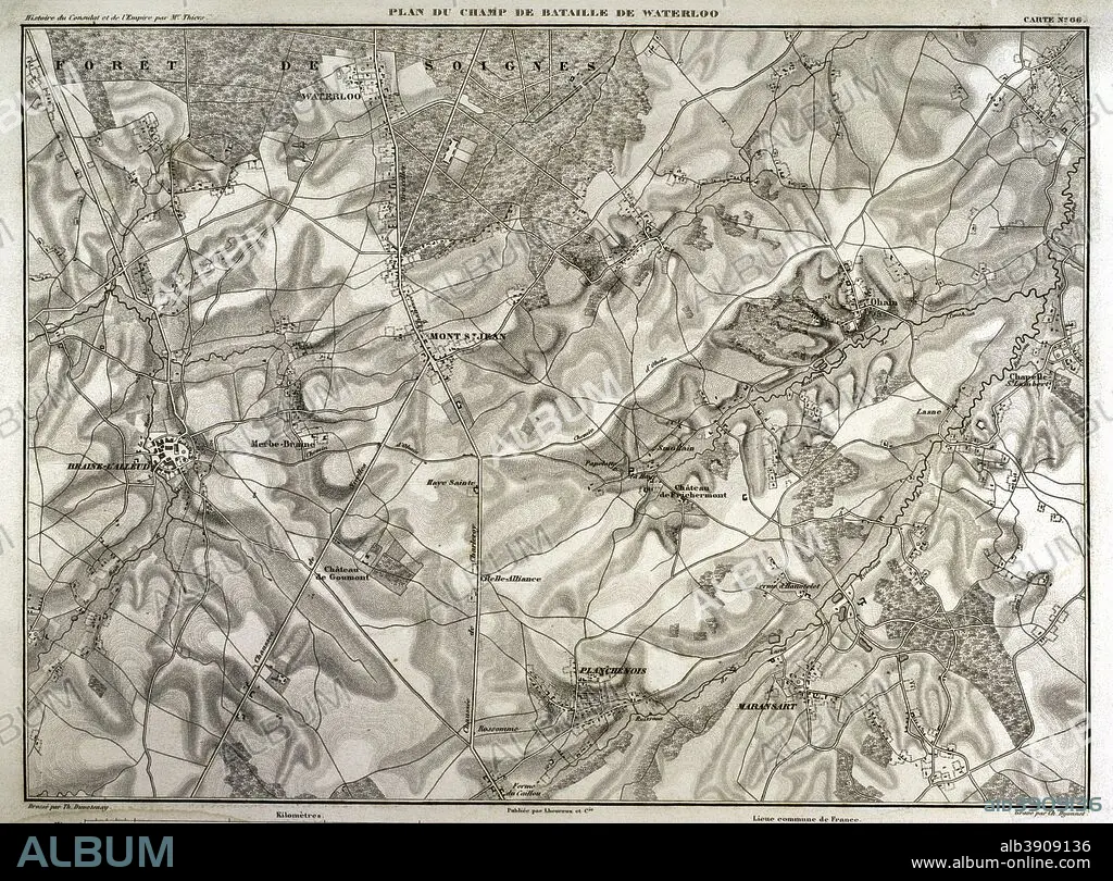
Napoleonic map. Battlefield of Waterloo (current territory of Belgium) where the battle took place on June 18, 1815. Confrontation between French troops (led by Napoleon I) and British, Dutch and German troops (led by the Duke of Wellington) and the Prussian army (directed by Gebhard von Blucher). Victory of the Seventh Coalition. Atlas de l'Histoire du Consulat et de l'Empire. History of the Consulate and the Empire of France under Napoleon by Marie Joseph Louis Adolphe Thiers (1797-1877). Drawings by Dufour, engravings by Dyonnet. Edited in Paris, 1864.
| Share |
|---|
 Pinterest Pinterest |
 Twitter Twitter |
 Facebook Facebook |
 Copy link Copy link |
 Email Email |
|
Add to another lightbox |
|
Add to another lightbox |


Buy this image.
Select the use:

Caption: Napoleonic map. Battlefield of Waterloo (current territory of Belgium) where the battle took place on June 18, 1815. Confrontation between French troops (led by Napoleon I) and British, Dutch and German troops (led by the Duke of Wellington) and the Prussian army (directed by Gebhard von Blucher). Victory of the Seventh Coalition. Atlas de l'Histoire du Consulat et de l'Empire. History of the Consulate and the Empire of France under Napoleon by Marie Joseph Louis Adolphe Thiers (1797-1877). Drawings by Dufour, engravings by Dyonnet. Edited in Paris, 1864.
Personalities: NAPOLÉON (1769-1821)
Credit: Album / Prisma
Releases: ? Model Release: No - ? Property Release: No
Rights questions?
Rights questions?
Image size: 5020 × 3710 px | 53.3 MB
Print size: 42.5 × 31.4 cm | 1976.4 × 1460.6 in (300 dpi)
Keywords: 1815 • 1864 • 19 CENTURY • 19TH CENTURY • 19TH CENTURY. • 19TH • 19TH-CENTURY • ADOLPHE THIERS • ANCIENT • ANTIQUE • ARMIES ARMY • ARMIES • ARMY'S • ARMY • ARMY, PRUSSIAN • ATLAS DE L'HISTOIRE DU CONSULAT ET DE L'EMPIRE • ATLAS DE L'HISTORIE DU CONSULAT ET DE L'EMPIRE • BATTLE OF WATERLOO • BATTLE OF WATERLOO, THE • BATTLE • BATTLEFIELD • BELGIEN • BELGIUM • BLUCHER • BRITAIN • BRITISH • BRUCHER • CARTOGRAPHY • COALITION VICTORY • COMBAT • COMBATTIMENTO • CONFRONTATION • DEFEAT • DESIGNING • DISPUTE • DOROGOBUZH • DRAWING • DRAWN • DUFOUR • DUKE OF WELLINGTON • DUTCH • DYONNET • EMPIRE • ENGLAND'S • ENGLAND • ENGLISH • ENGRAVED • ENGRAVING (ARTWORK) • ENGRAVING • ENGRAVING. • ENGRAVINGS • ETCHING • EUROPA • EUROPE • EUROPEA • EUROPEAN • EUROPEANS • FIGHT • FIGHTING • FIRST FRENCH EMPIRE • FRANCE • FRANCE. • FRANÇAIS • FRENCH EMPIRE • FRENCH • GEBHARD VON BRUCHER • GEHBARD LEBERECHT VON BRUCHER • GEOGRAFIA • GEOGRAPHICAL • GEOGRAPHY • GERMAN • GERMANS • GERMANY • GREAT BRITAIN • GREAT-BRITAIN • GUERRA • HAARLEM, TOWNSCAPE (NL) • HISTORIA UNIVERSAL • HISTORIA • HISTORIC • HISTORICAL • HISTORY NETHERLANDS • HISTORY OF THE CONSULATE AND THE EMPIRE OF FRANCE UNDER NAPOLEON • HISTORY OF THE CONSULATE AND THE NAPOLEON EMPIRE • HISTORY • HISTORY, NETHERLANDS • HISTORY. • HOLLAND • HUNDRED YEARS WAR • INGLES • LA BELLE ALLIANCE • LA FRANCE • LANDSCAPE, NETHERLANDS • MAP MAKING • MAP • MAPS • MARIE JOSEPH LOUIS ADOLPHE THIERS • MODERN AGE • MODERN ERA • MODERN PERIOD • NAPOLEON I BONAPARTE • NAPOLEON I • NAPOLEON'S FRENCH EMPIRE • NAPOLEON • NAPOLEONIC EMPIRE • NAPOLEONIC ERA • NAPOLEONIC MAP • NAPOLEONIC PERIOD • NAPOLEONIC WAR • NAPOLEONIC WARS • NETHERLAND LANDSCAPE • NETHERLANDISH • NETHERLANDS • NETHERLANDS, HISTORY • NETHERLANDS, LANDSCAPE • NETHERLANDS, THE • NINETEENTH CENTURY • OLD • PEACE, NAPOLEONIC WARS • PLAN (CARTOGRAPHY) • PLAN • PLANE • PRINT • PRUSIA • PRUSSIA • PRUSSIAN • RUSIA • RUSSIA • SCUFFLE • SEVENTH COALITION • STRUGGLE • SURFACE • TERRITORY • THIERS • TOWNSCAPE: HAARLEM (NL) • U. K. • UNITED KINGDOM • WAR • WARFARE • WARS • WATERLOO • XIX CENTURY
