alb4859081
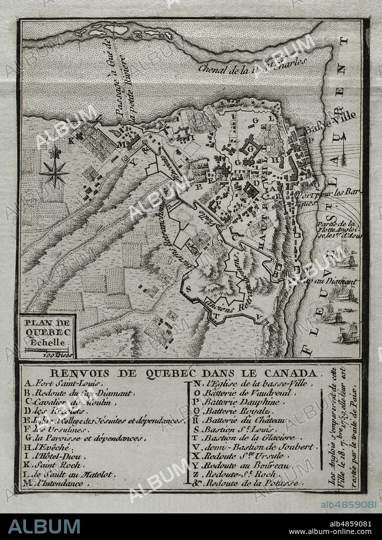
JEAN DE BEAURAIN (1696-1771). FRENCH GEOGRAPHER.. Seven Years War (1756-1763). Map of Quebec, 1759. Canada. French Colony of the Viceroyalty of New France. On September 18, 1759, the British captured the city. Published in 1765 by the cartographer Jean de Beaurain (1696-1771) as an illustration of his Great Map of Germany, with the events that took place during the Seven Years War. Engraving. French edition, 1765. Military Historical Library of Barcelona (Biblioteca Histórico Militar de Barcelona). Catalonia. Spain.
| Share |
|---|
 Pinterest Pinterest |
 Twitter Twitter |
 Facebook Facebook |
 Copy link Copy link |
 Email Email |
|
Add to another lightbox |
|
Add to another lightbox |


Buy this image.
Select the use:

Caption:
Seven Years War (1756-1763). Map of Quebec, 1759. Canada. French Colony of the Viceroyalty of New France. On September 18, 1759, the British captured the city. Published in 1765 by the cartographer Jean de Beaurain (1696-1771) as an illustration of his Great Map of Germany, with the events that took place during the Seven Years War. Engraving. French edition, 1765. Military Historical Library of Barcelona (Biblioteca Histórico Militar de Barcelona). Catalonia. Spain.
Location:
Historical Military Library of Barcelona. Catalonia. Spain.
Credit:
Album / Prisma
Releases:
Model: No - Property: No
Rights questions?
Rights questions?
Image size:
3543 x 4763 px | 48.3 MB
Print size:
30.0 x 40.3 cm | 11.8 x 15.9 in (300 dpi)
Keywords:
1759 • 1765 • 18 CENTURY • 18 SEPTEMBER 1759 • 18TH CENTURY • 18TH CENTURY, THE • 18TH • AMERICA • AMERICAN CONTINENT • AMERICAS • ANCIENT • ANTIQUE • BATTLE OF QUEBEC • BATTLE OF THE PLAINS OF ABRAHAM • BATTLE • BEAURAIN • CANADA • CANADIAN • CARTOGRAPHY • COLOGNE • COLONIA • COLONIAL CONTROL • COLONIAL RULE • COLONIAL WAR • COLONIAL WARS • COLONIALISM • COLONY • COMBAT • COMPASS CARD • COMPASS ROSE • COMPASS • DISPUTE • EIGHTEENTH CENTURY • ENGRAVED • ENGRAVING (ARTWORK) • ENGRAVING • ENGRAVING. • ENGRAVINGS • ETCHING • FIGHT • FIGHTING • FRANCE, HISTORY • FRENCH AND INDIAN WAR • FRENCH COLONIAL EMPIRE • FRENCH COLONIES • FRENCH COLONY • FRENCH EDITION • FRENCH INDIAN WAR • FRENCH-INDIAN WAR • HISTORIA DE FRANCIA • HISTORIA UNIVERSAL • HISTORIA • HISTORICAL MILITARY LIBRARY OF BARCELONA. CATALONIA. SPAIN. • HISTORY FRANCE • HISTORY OF FRANCE • HISTORY • HISTORY, FRANCE • HUNDRED YEARS WAR • INTERNATIONAL CONFLICT • JEAN DE BEAURAIN (1696-1771). FRENCH GEOGRAPHER. • JEAN DE BEAURAIN • MAP MAKING • MAP • MAPS • MODERN AGE • MODERN ERA • MODERN PERIOD • NEW FRANCE • NORTH AMERICA • NORTH AMERICAN • OLD MAP • OLD • PLAN (CARTOGRAPHY) • PLAN • PLANE • PRINT • QUEBEC • SCUFFLE • SEPTEMBER 18 • SEVEN YEARS WAR • SEVEN YEARS' WAR • SILESIAN WAR • STRUGGLE • VICEROYALTY OF NEW FRANCE • VICEROYALTY • WAR IN THE COLONIES • WAR • WAR, SEVEN YEARS • WAR, SILESIAN • WARFARE • WARS • WIND ROSE • WINDROSE • XVIII CENTURY
