alb5413620
Joan Blaeu, Duchy of Brabant Map, 17th Century
| Share |
|---|
 Pinterest Pinterest |
 Twitter Twitter |
 Facebook Facebook |
 Copy link Copy link |
 Email Email |
|
Add to another lightbox |
|
Add to another lightbox |


Buy this image.
Select the use:

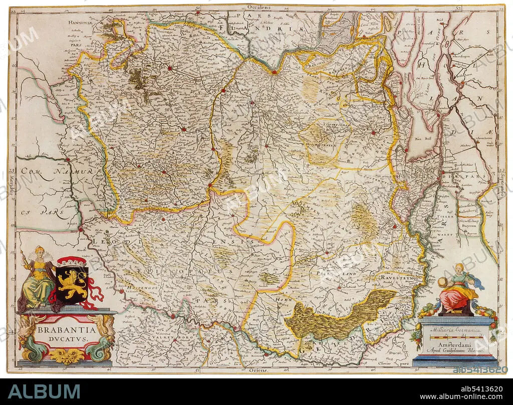
Title: Joan Blaeu, Duchy of Brabant Map, 17th Century
Caption: Duchy of Brabant was a State of the Holy Roman Empire established in 1183. It developed from the Landgraviate of Brabant and formed the heart of the historic Low Countries, part of the Burgundian Netherlands from 1430 and of the Habsburg Netherlands from 1482, until it was partitioned after the Dutch revolt. Today all the duchy's former territories, apart from exclaves, are in Belgium except for the Dutch province of North Brabant. Joan Blaeu (1596-1673) was a Dutch cartographer, the son of cartographer Willem Blaeu. In 1635 they published the Atlas Novus (full title: Theatrum orbis terrarum, sive, Atlas novus) in two volumes. The Atlas Maior is the final version of Joan Blaeu's atlas, published in Amsterdam between 1662 and 1672, in Latin, French, Dutch, German and Spanish, containing 594 maps and around 3,000 pages of text.
Credit: Album / Science Source
Releases: ? Model Release: No - ? Property Release: No
Rights questions?
Rights questions?
Image size: 4350 × 3201 px | 39.8 MB
Print size: 36.8 × 27.1 cm | 1712.6 × 1260.2 in (300 dpi)
Keywords: 1600S • 17TH CENTURY • 17TH CENTURY. • 17TH • 17TH-CENTURY • AGE • ÂGÉS • ATLAS • BELGIUM • BLAEU • BRABANT • CARTOGRAPHIC • CARTOGRAPHICAL • CARTOGRAPHY • CELEBRITIES • CELEBRITY • CENTURY • DUCHY • DUTCH / NETHERLANDISH • DUTCH • FAMOUS PEOPLE • FAMOUS • GEOGRAFIA • GEOGRAPHIC • GEOGRAPHICAL • GEOGRAPHY • GOLDEN • HISTORIC • HISTORICAL • HISTORY • IMPORTANT • INFLUENTIAL • JOAN • MAKING • MAP MAKING • MAP • MAP-MAKING • MAPMAKING • NOTABLE • NOVUS • OF • OLD • SEVENTEETH • WELL-KNOWN • XVII CENTURY
