alb4859779
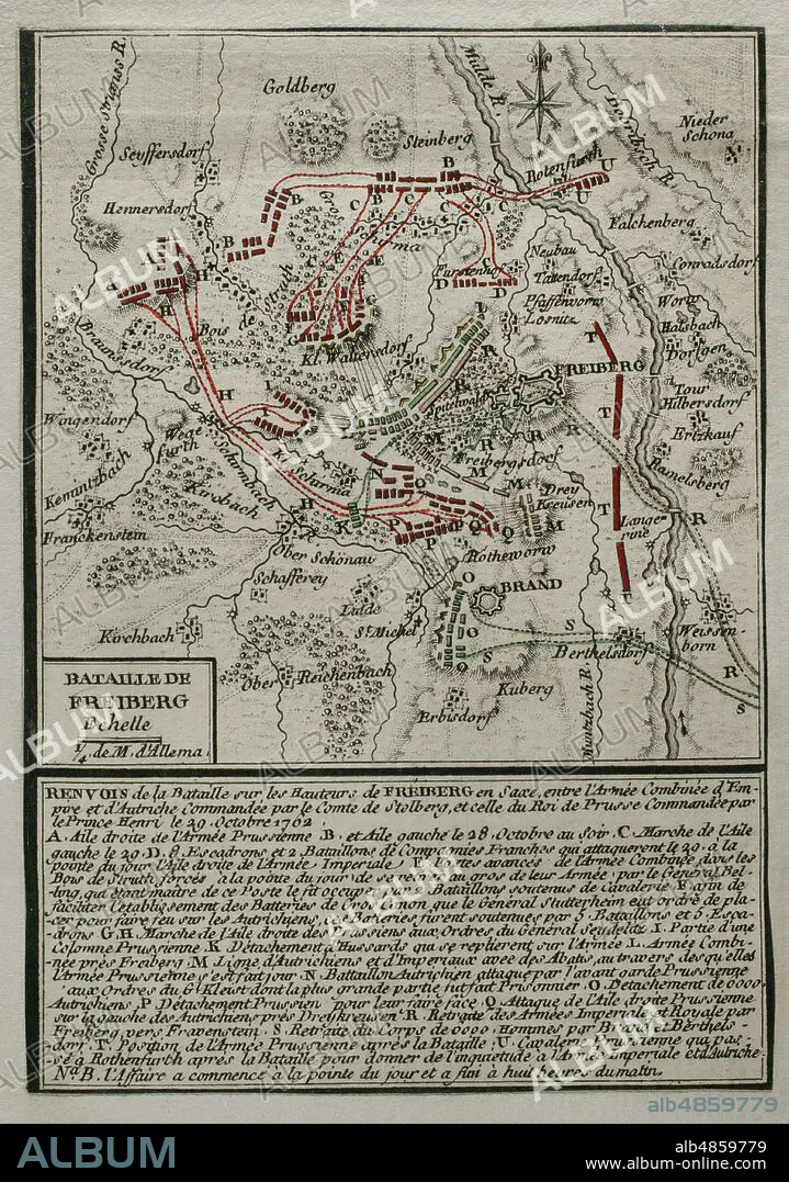
JEAN DE BEAURAIN (1696-1771). FRENCH GEOGRAPHER.. Seven Years War (1756-1763). Third Silesian War. Map of the Battle of Freiberg (29 October 1762). The Prussian army led by Prince Henry of Prussia, defeated an Austrian army under Frederick Charles of Stolberg-Gedern and Andras Hadik. Published in 1765 by the cartographer Jean de Beaurain (1696-1771) as an illustration of his Great Map of Germany, with the events that took place during the Seven Years War. Etching and engraving. French edition, 1765. Military Historical Library of Barcelona (Biblioteca Histórico Militar de Barcelona). Catalonia. Spain.
| Share |
|---|
 Pinterest Pinterest |
 Twitter Twitter |
 Facebook Facebook |
 Copy link Copy link |
 Email Email |
|
Add to another lightbox |
|
Add to another lightbox |


Buy this image.
Select the use:

Caption: Seven Years War (1756-1763). Third Silesian War. Map of the Battle of Freiberg (29 October 1762). The Prussian army led by Prince Henry of Prussia, defeated an Austrian army under Frederick Charles of Stolberg-Gedern and Andras Hadik. Published in 1765 by the cartographer Jean de Beaurain (1696-1771) as an illustration of his Great Map of Germany, with the events that took place during the Seven Years War. Etching and engraving. French edition, 1765. Military Historical Library of Barcelona (Biblioteca Histórico Militar de Barcelona). Catalonia. Spain.
Location: Historical Military Library of Barcelona. Catalonia. Spain.
Credit: Album / Prisma
Releases: ? Model Release: No - ? Property Release: No
Rights questions?
Rights questions?
Image size: 3366 × 4792 px | 46.1 MB
Print size: 28.5 × 40.6 cm | 1325.2 × 1886.6 in (300 dpi)
Keywords: 1762 • 1765 • 18 CENTURY • 18TH CENTURY • 18TH CENTURY, THE • 18TH CENTURY. • 18TH • ANDRAS HADIK • ARMY, PRUSSIAN • AUSTRIA • AUSTRIAN ARMY • AUSTRIAN CORPS • AUSTRIAN TROOPS • AUSTRIAN • BATTLE OF FREIBERG • BATTLE • BATTLEFIELD • BATTLEGROUND • BEAURAIN • CARTOGRAPHY • COLONIAL WARS • COMBAT • CONFLICT • CONFLICTS • DEUTSCHLAND • DISPUTE • ENGRAVED • ENGRAVING (ARTWORK) • ENGRAVING • ENGRAVING. • ENGRAVINGS • ETCHING • EUROPA • EUROPE • EUROPEA • EUROPEAN • EUROPEANS • FIGHT • FIGHTING • FREDERICK CHARLES OF STOLBERG-GEDERN • FREDERICK CHARLES • FREIBERG (D) • FREIBERG CATHEDRAL (D) • FREIBERG • FRENCH EDITION • GERMANY HISTORY • GERMANY • GREAT MAP OF GERMANY • GUERRA • HENRY OF PRUSSIA • HISTORIA DE ALEMANIA • HISTORIA UNIVERSAL • HISTORIA • HISTORICAL MILITARY LIBRARY OF BARCELONA. CATALONIA. SPAIN. • HISTORY AUSTRIA • HISTORY OF GERMANY • HISTORY OF PRUSSIA • HISTORY PRUSSIA • HISTORY • HISTORY, PRUSSIA • HISTORY. • HUNDRED YEARS WAR • JEAN DE BEAURAIN (1696-1771). FRENCH GEOGRAPHER. • JEAN DE BEAURAIN • MAP MAKING • MAP • MAPS • MILITARY STRATEGY • MILITARY TACTICS • MODERN AGE • MODERN ERA • MODERN PERIOD • MULDE RIVER • MULDE • OCTOBER 29 • PLAN (CARTOGRAPHY) • PLAN • PLANE • PRINCE HENRY OF PRUSSIA • PRINCE HENRY • PRINCE STOLBERG • PRINT • PRUSIA • PRUSSIA • PRUSSIA, HISTORY • PRUSSIAN ARMY • REICHSARMY • SAXONY • SCUFFLE • SEVEN YEARS WAR • SEVEN YEARS' WAR • SILESIA • SILESIAN WAR • STRATEGY • STRUGGLE • TACTICS • THIRD SILESIAN WAR • WAR IN THE COLONIES • WAR • WAR, SEVEN YEARS • WAR, SILESIAN • WARFARE • WARS • XVIII CENTURY
