alb5414168
Joan Blaeu, Virginia and Florida Coast Map, 17th Century
| Share |
|---|
 Pinterest Pinterest |
 Twitter Twitter |
 Facebook Facebook |
 Copy link Copy link |
 Email Email |
|
Add to another lightbox |
|
Add to another lightbox |


Buy this image.
Select the use:

Title: Joan Blaeu, Virginia and Florida Coast Map, 17th Century
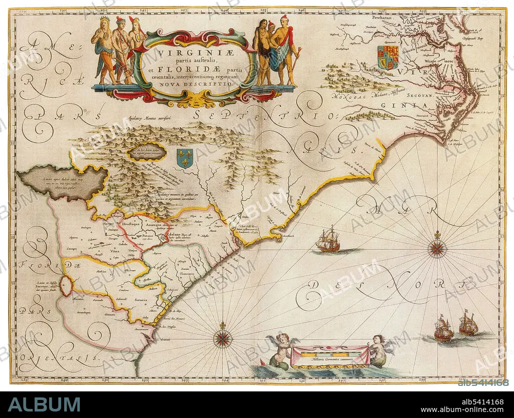
Caption: The Colony of Virginia, chartered in 1606 and settled in 1607, was the first enduring English colony in North America. The founder of the new colony was the Virginia Company with the first settlement in Jamestown on the north bank of the James River. Florida was the first region of the continental United States to be visited and settled by Europeans. The geographical area of Florida diminished with the establishment of English settlements to the north and French claims to the west. Joan Blaeu (1596-1673) was a Dutch cartographer, the son of cartographer Willem Blaeu. In 1635 they published the Atlas Novus (full title: Theatrum orbis terrarum, sive, Atlas novus) in two volumes. The Atlas Maior is the final version of Joan Blaeu's atlas, published in Amsterdam between 1662 and 1672, in Latin, French, Dutch, German and Spanish, containing 594 maps and around 3,000 pages of text. The Blaeu maps emphasized fine art and colours, being the most expensive of the time.
Credit: Album / Science Source
Releases: ? Model Release: No - ? Property Release: No
Rights questions?
Rights questions?
Image size: 4200 × 3199 px | 38.4 MB
Print size: 35.6 × 27.1 cm | 1653.5 × 1259.4 in (300 dpi)
Keywords: 1600S • 17TH CENTURY • 17TH CENTURY. • 17TH • 17TH-CENTURY • AGE • ÂGÉS • AMERICAN • ATLAS • BLAEU • CARTOGRAPHIC • CARTOGRAPHICAL • CARTOGRAPHY • CATALAN • CELEBRITIES • CELEBRITY • CENTURY • CHART • COAST • COLONY • DUTCH / NETHERLANDISH • DUTCH • FAMOUS PEOPLE • FAMOUS • FLORIDA • GEOGRAFIA • GEOGRAPHIC • GEOGRAPHICAL • GEOGRAPHY • GOLDEN • HISTORIC • HISTORICAL • HISTORY • IMPORTANT • INFLUENTIAL • JOAN • MAKING • MAP MAKING • MAP • MAP-MAKING • MAPMAKING • NAVIGATION • NAVIGATIONAL • NOTABLE • NOVUS • OF • OLD • PORTOLAN • PORTOLANO • PORTULAN • SEVENTEETH • STATES • UNITED • US • USA • VIRGINIA • WELL-KNOWN • XVII CENTURY
