alb3793885
Malaspina Glacier, Alaska
| Share |
|---|
 Pinterest Pinterest |
 Twitter Twitter |
 Facebook Facebook |
 Copy link Copy link |
 Email Email |
|
Add to another lightbox |
|
Add to another lightbox |


Buy this image.
Select the use:

Title:
Malaspina Glacier, Alaska
Caption:
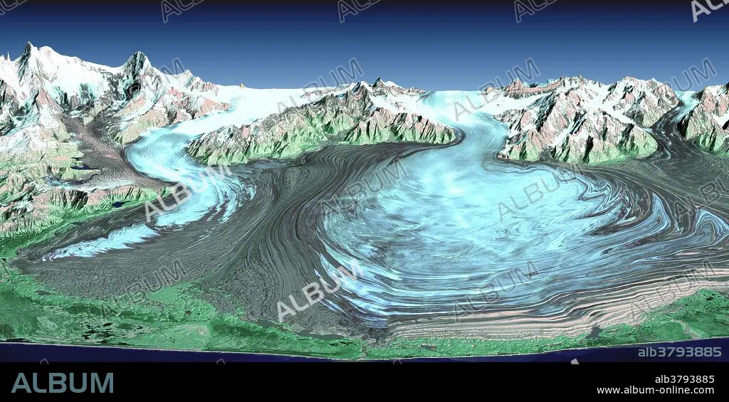
Malaspina Glacier in southeastern Alaska is considered the classic example of a piedmont glacier. Piedmont glaciers occur where valley glaciers exit a mountain range onto broad lowlands and spread to become wide lobes. Malaspina Glacier is actually a compound glacier, formed by the merger of several valley glaciers. In total, Malaspina Glacier is up to 40 miles wide and extends up to 28 miles from the mountain front nearly to the sea. This perspective view was created from a Landsat satellite image and an elevation model generated by the Shuttle Radar Topography Mission (SRTM). The SRTM mission, launched aboard the Space Shuttle Endeavour on February 11, 2000, was designed to collect three-dimensional measurements of the Earth's surface. Landsat views both visible and infrared light, which have been combined here into a color composite that generally shows glacial ice in light blue, snow in white, vegetation in green, bare rock in grays and tans, and the ocean (foreground) in dark blue. The back (northern) edge of the data set forms a false horizon that meets a false sky.
Category:
Astronomy & Space
Credit:
Album / NASA/Science Source
Releases:
Image size:
3544 x 1772 px | 18.0 MB
Print size:
30.0 x 15.0 cm | 11.8 x 5.9 in (300 dpi)
Keywords:
AERIAL PHOTOGRAPHY • AERIAL • AGASSIZ GLACIER • AGASSIZ • ALASKA • ASTRONOMY & SPACE • COLOR-ENHANCED • COLORED • COMPOUND GLACIER • COMPOUND • EARTH OBSERVATION • ELEVATION • ENDEAVOR IMAGE • FALSE-COLOR • FEBRUARY 2000 • FROM SPACE • GEOGRAFIA • GEOGRAPHICAL • GEOGRAPHY • GEOLOGIA • GEOLOGICAL FORMATION • GEOLOGY • GLACIAL • GLACIAR • GLACIER • HORIZONTAL • LANDSAT SATELLITE • LANDSAT • LANDSCAPE • LANDSCAPES • LOBE • LOBES • LOBULE • MALASPINA GLACIER • MALASPINA • MERGED • MISSION • PIEDMONT GLACIER • PIEDMONT • RADAR IMAGE • RADAR TOPOGRAPHY • SATELLITE IMAGE • SATELLITE PHOTOGRAPHY • SATELLITE • SEWARD GLACIER • SEWARD • SHUTTLE PHOTOGRAPHY • SHUTTLE RADAR TOPOGRAPHY MISSION • SHUTTLE RADAR TOPOGRAPHY • SPACE SHUTTLE ENDEAVOUR • SPACE SHUTTLE IMAGE • SRTM IMAGE • SRTM • TOPOGRAPHIC • TOPOGRAPHY • VALLEY
