alb5409179
Joan Blaeu, Oxfordshire Map, England, 17th Century
| Share |
|---|
 Pinterest Pinterest |
 Twitter Twitter |
 Facebook Facebook |
 Copy link Copy link |
 Email Email |
|
Add to another lightbox |
|
Add to another lightbox |


Buy this image.
Select the use:

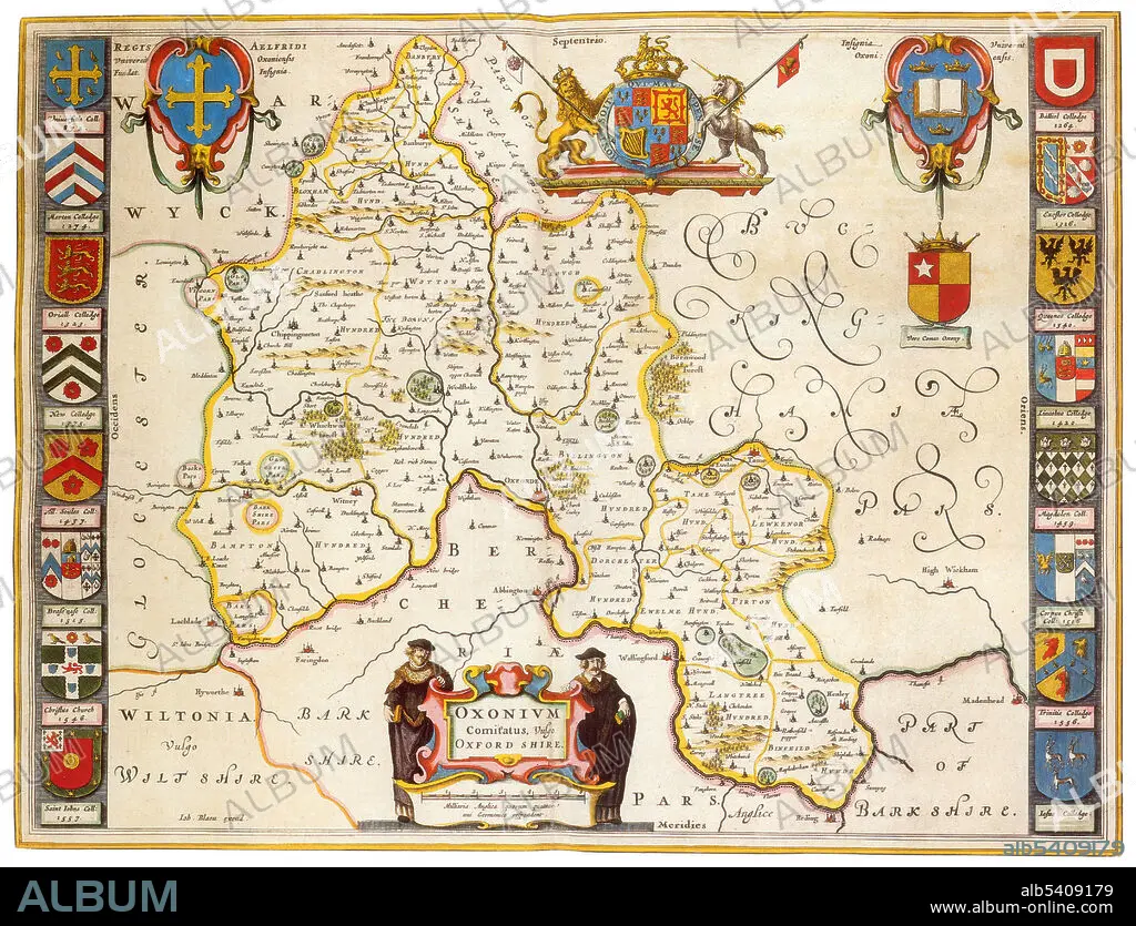
Title: Joan Blaeu, Oxfordshire Map, England, 17th Century
Caption: Oxfordshire was recorded as a county in the early years of the 10th century and lies between the River Thames to the south, the Cotswolds to the west, the Chilterns to the east and the Midlands to the north, with spurs running south to Henley-on-Thames and north to Banbury. Joan Blaeu (September 23, 1596, December 21, 1673) was a Dutch cartographer, the son of cartographer Willem Blaeu. In 1635 they published the Atlas Novus (full title: Theatrum orbis terrarum, sive, Atlas novus) in two volumes. The Atlas Maior is the final version of Joan Blaeu's atlas, published in Amsterdam between 1662 and 1672, in Latin, French, Dutch, German and Spanish, containing 594 maps and around 3,000 pages of text. The Blaeu maps emphasized fine art and colours, being the most expensive of the time. The Atlas Maior is widely considered a masterpiece of the Golden Age of Dutch/Netherlandish cartography.
Credit: Album / Science Source
Releases: ? Model Release: No - ? Property Release: No
Rights questions?
Rights questions?
Image size: 4275 × 3265 px | 39.9 MB
Print size: 36.2 × 27.6 cm | 1683.1 × 1285.4 in (300 dpi)
Keywords: 1600S • 17TH CENTURY • 17TH CENTURY. • 17TH • 17TH-CENTURY • AGE • ÂGÉS • ATLAS • BLAEU • CARTOGRAPHIC • CARTOGRAPHICAL • CARTOGRAPHY • CELEBRITIES • CELEBRITY • CENTURY • DUTCH / NETHERLANDISH • DUTCH • ENGLAND • ENGLISH • FAMOUS PEOPLE • FAMOUS • GEOGRAFIA • GEOGRAPHIC • GEOGRAPHICAL • GEOGRAPHY • GOLDEN • HISTORIC • HISTORICAL • HISTORY • IMPORTANT • INFLUENTIAL • JOAN • MAKING • MAP MAKING • MAP • MAP-MAKING • MAPMAKING • NOTABLE • NOVUS • OF • OLD • OXFORDSHIRE • SEVENTEETH • WELL-KNOWN • XVII CENTURY
