alb4442614
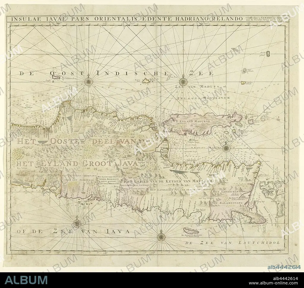
Map of the eastern part of Java, Insulae Javae pars orientalis Edinte Hadriano Relando (title on object), Map from East Java. At the top a view of Batavia from the water. There are five compass roses and topographical details have been added to the map: rice fields, mountains, wildlife etc. With the island of Madura. See the left half for the scale. Right half of a map of the entire island of Java, maps of separate countries or regions, Java, Madura, Adriaan Reeland (mentioned on object), Amsterdam, 1728, paper, engraving, h 559 mm × w 628 mm.
| Share |
|---|
 Pinterest Pinterest |
 Twitter Twitter |
 Facebook Facebook |
 Copy link Copy link |
 Email Email |
|
Add to another lightbox |
|
Add to another lightbox |


Buy this image.
Select the use:

Caption:
Map of the eastern part of Java, Insulae Javae pars orientalis Edinte Hadriano Relando (title on object), Map from East Java. At the top a view of Batavia from the water. There are five compass roses and topographical details have been added to the map: rice fields, mountains, wildlife etc. With the island of Madura. See the left half for the scale. Right half of a map of the entire island of Java, maps of separate countries or regions, Java, Madura, Adriaan Reeland (mentioned on object), Amsterdam, 1728, paper, engraving, h 559 mm × w 628 mm
Personalities:
Credit:
Album / quintlox
Releases:
Image size:
6050 x 5430 px | 94.0 MB
Print size:
51.2 x 46.0 cm | 20.2 x 18.1 in (300 dpi)
Keywords:
1728 • ADDED • ADRIAAN REELAND • AMSTERDAM • BATAVIA • EAST JAVA • EASTERN PART • ENGRAVED • ENGRAVING (ARTWORK) • ENGRAVING • ENGRAVING. • ENGRAVINGS • ENTIRE ISLAND • ETCHING • FIVE COMPASS ROSES • INSULAE JAVAE PARS ORIENTALIS EDINTE HADRIANO RELANDO • ISLA • ISLAND • ISLANDS • JAVA • LEFT HALF • MADURA • MAP • MAPS • MENTIONED • MOUNTAIN RANGE • MOUNTAINS • OBJECT • OBJECTS • PANORAMIC VIEW • PAPER AND PACKAGE PRODUCTS • PAPER • PLAN (CARTOGRAPHY) • PRINT • RANGE • REGIONS • RICE FIELDS • RIGHT HALF • SCALE • SEE • SEPARATE COUNTRIES • SIERRA • SIGHT • TITLE • TOP • TOPOGRAPHICAL DETAILS • UMBRELLA • VIEW'S • VIEW • WATER • WILDLIFE ETC
