alb3842190
Hurricane Isabel, 2003
| Share |
|---|
 Pinterest Pinterest |
 Twitter Twitter |
 Facebook Facebook |
 Copy link Copy link |
 Email Email |
|
Add to another lightbox |
|
Add to another lightbox |


Title:
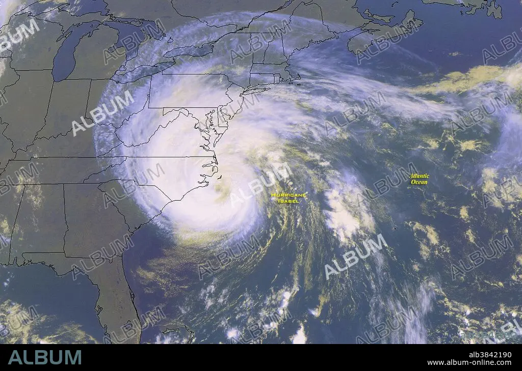
Hurricane Isabel, 2003
Caption:
NOAA satellite image of Hurricane Isabel taken on September 18, 2003, at 11:45 a.m. EDT. Hurricane Isabel was the costliest, deadliest, and strongest hurricane in the 2003 Atlantic hurricane season. The ninth named storm, fifth hurricane, and second major hurricane of the season, Isabel formed near the Cape Verde Islands from a tropical wave on September 6 in the tropical Atlantic Ocean. It moved northwestward, and within an environment of light wind shear and warm waters it steadily strengthened to reach peak winds of 165 mph on September 11. After fluctuating in intensity for four days, Isabel gradually weakened and made landfall on the Outer Banks of North Carolina with winds of 105 mph on September 18. It quickly weakened over land and became extratropical over western Pennsylvania the next day. Moderate to severe damage extended up the Atlantic coastline and as far inland as West Virginia. Roughly six million people were left without electric service in the eastern United States from the strong winds of Isabel. Rainfall from the storm extended from South Carolina to Maine, and westward to Michigan. Throughout the path of Isabel, damage totaled about 5.7 billion (2003 USD, $7.31 billion 2014 USD).
Credit:
Album / NOAA/Science Source
Releases:
Model: No - Property: No
Rights questions?
Rights questions?
Image size:
4200 x 2771 px | 33.3 MB
Print size:
35.6 x 23.5 cm | 14.0 x 9.2 in (300 dpi)
Keywords:
2003 ATLANTIC HURRICANE SEASON • 2003 • 21ST CENTURY • 21ST • 21TH CENTURY • AMERICA • AMERICAN • ATLANTIC BASIN • ATLANTIC HURRICANE • ATMOSPHERIC CONDITIONS • ATMOSPHERIC • CATEGORY 5 • COSTLIEST • COSTLY • DEADLIEST • DEADLY • EARTH FROM SPACE • EARTH SCIENCE • GEOGRAPHIC • GEOGRAPHICAL • GEOGRAPHY • GEOSTATIONARY OPERATIONAL ENVIRONMENTAL SATELLITE • GOES IMAGE • HISTORIC • HISTORICAL • HISTORY • HURRICANE ISABEL • INTENSE • METEOROLOGICAL • METEOROLOGY • METEOROLOGY • MOREHEAD CITY • NATURAL PHENOMENA • NATURAL PHENOMENON • NOAA • NORTH CAROLINA • SATELLITE IMAGERY • SCIENCE • SEPTEMBER 18 • SEPTEMBER 18TH • SÉVÈRE • STORM • STRONG WEATHER • STRONGEST • TOPOGRAPHICAL • TOPOGRAPHY • TROPICAL CYCLONE • TROPICAL HURRICANE • TROPICAL STORM • UNITED STATES • US • USA • VIOLENT • WEATHER EVENT • WEATHER
