alb4101601
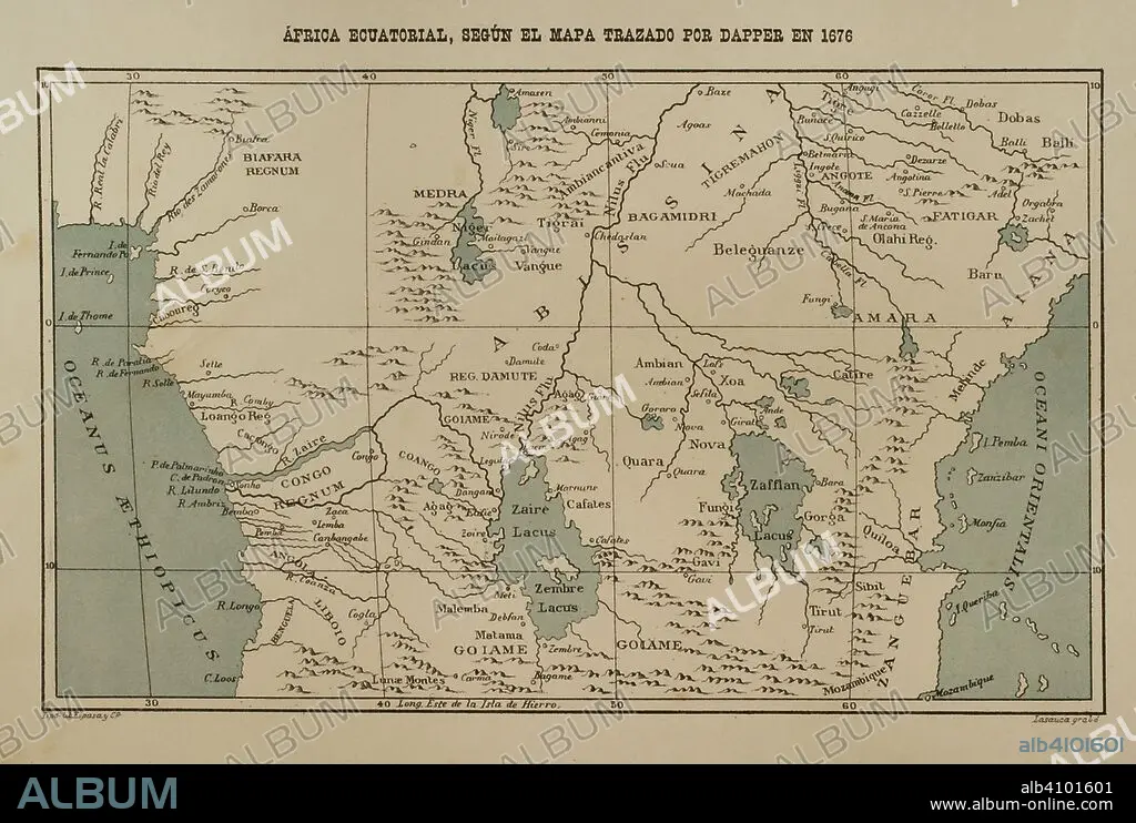
Equatorial Africa according to the map drawn by Dapper in 1616. Africa inexplorada, el Continente Misterioso by Henry Morton Stanley, c. 1887.
| Share |
|---|
 Pinterest Pinterest |
 Twitter Twitter |
 Facebook Facebook |
 Copy link Copy link |
 Email Email |
|
Add to another lightbox |
|
Add to another lightbox |


Caption:
Equatorial Africa according to the map drawn by Dapper in 1616. Africa inexplorada, el Continente Misterioso by Henry Morton Stanley, c. 1887.
Credit:
Album / Prisma
Releases:
Model: No - Property: No
Rights questions?
Rights questions?
Image size:
4961 x 3336 px | 47.3 MB
Print size:
42.0 x 28.2 cm | 16.5 x 11.1 in (300 dpi)
Keywords:
1616 • 1676 • 17TH CENTURY • 17TH • 1887 • 19TH CENTURY • 19TH • ABYSSINIA • ABYSSINIAN • AFRICA EXPLORATIONS • AFRICA • AFRICAN CONTINENT • AFRICAN GREAT LAKE • AFRICAN • AFRICANS • ATLANTIC OCEAN • ATLANTIC • BIAFRA • CARTOGRAPHY • CENTRAL AFRICA • CENTRAL AFRICAN • COLONIALISM • COLONIES • CONGO RIVER • CONGO • CONTEMPORARY AGE • CONTEMPORARY PERIOD • DAPPER • ENGRAVED • ENGRAVING (ARTWORK) • ENGRAVING • ENGRAVING. • ENGRAVINGS • EPOCA • EPOCH • EQUATORIAL AFRICA • EQUATORIAL • ERA • ETCHING • EUROPEA • EUROPEAN EXPLORATIONS OF AFRICA • EUROPEAN • EXPEDITION • EXPEDITIONS • EXPLORATION • EXPLORE • GEOGRAPHICAL • GEOGRAPHY • GREAT LAKES • HENRY MORTON STANLEY • HISTORIA UNIVERSAL • HISTORIA • HISTORIC • HISTORICAL • HISTORY • INDIAN OCEAN • INDICATED • JOHN ROWLANDS • JOURNEY • JOURNEYMAN'S TRAVEL • JOURNEYMAN'S TRAVELS • KINGDOM • LACUNA • LAKE LIVINSGSTONE • LAKE TANGANYIKA • LAKE VICTORIA • LAKE • LAKES AREA • LEISURE • MAP MAKING • MAP • MAPPING • MAPS • MODERN AGE • MODERN ERA • MODERN PERIOD • MOZAMBIQUE • MYSTERIOUS CONTINENT • OCEAN, ATLANTIC • PLAN (CARTOGRAPHY) • POND • PRINT • REGION • STANLEY • TERRITORY • TRAVEL • TRAVELING • TRIP • VOYAGE • XIX CENTURY • XVII CENTURY • ZAFFLAN • ZAIRE RIVER • ZAIRE • ZANZIBAR
